Reculver facts for kids
Quick facts for kids Reculver |
|
|---|---|
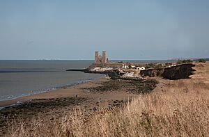
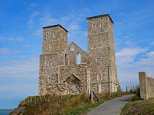 The twin towers of St Mary's Church |
|
| Area | 2.79 sq mi (7.2 km2) |
| Population | 4,400 (2021 census) |
| • Density | 1,577/sq mi (609/km2) |
| OS grid reference | TR2269 |
| District | |
| Shire county | |
| Region | |
| Country | England |
| Sovereign state | United Kingdom |
| Post town | HERNE BAY |
| Postcode district | CT6 |
| Dialling code | 01227 |
| Police | Kent |
| Fire | Kent |
| Ambulance | South East Coast |
| EU Parliament | South East England |
| UK Parliament |
|
Reculver is a village and coastal area in Kent, south-east England. It is about 3 miles (4.8 km) east of Herne Bay.
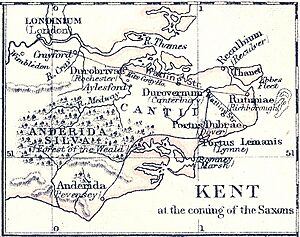
Long ago, Reculver was in a very important spot. It was at the north-western end of the Wantsum Channel. This was a sea route that separated the Isle of Thanet from the rest of Kent. Because of its location, the Romans built a small fort here in 43 AD. Later, in the late 2nd century, they built a bigger fort called Regulbium. This fort became one of the famous Saxon Shore forts.
By the 7th century, Reculver was owned by the Anglo-Saxon kings of Kent. In 669 AD, a monastery dedicated to St Mary was built on the Roman fort site. King Eadberht II of Kent was buried there in the 760s. During the Middle Ages, Reculver was a busy town with a market and a yearly fair. It was also part of the Cinque Port of Sandwich.
However, the settlement started to shrink. The Wantsum Channel filled up with silt, making it unusable for ships. Also, coastal erosion slowly washed away many buildings from the soft sandy cliffs. By the late 1700s, most of the village was abandoned. In the early 1800s, much of the church was pulled down. Protecting the church ruins and the rest of Reculver from the sea is still a big challenge today.
In the 20th century, Reculver started to grow again because of tourism. Now, there are two caravan parks. The 2021 census showed that about 4,400 people live in the Reculver area. The Reculver coastline is a special place for nature. It is a Site of Special Scientific Interest, a Special Protection Area, and a Ramsar site. It includes most of Reculver Country Park and Bishopstone Cliffs local nature reserve. Rare plants and insects live here, and it's an important stop for migrating birds. The area also has interesting geology.
Contents
History of Reculver
What's in a Name?
The oldest name for Reculver was Regulbium. This was a Latin word from the early 5th century. It came from an older British word that meant "at the headland" or "great headland." Later, in Old English, it became Raculf or Raculfceastre. The word "ceastre" often meant a Roman city or walled town. This is how we got the modern name "Reculver."
Ancient Times: Prehistoric and Roman Reculver
People have lived in the Reculver area for a very long time. Stone Age tools have been found in the cliffs. There is also evidence of a large settlement from the late Bronze Age and Iron Age.
The Romans arrived in Britain in 43 AD. They built a small fort at Reculver because it was a good place to watch the sea. A Roman road was built from Reculver to Canterbury. This shows that the Romans were present here from early on. A larger fort, called a castrum, was started in the late 2nd century. Archaeologists found pieces of a special plaque that recorded the building of this fort. It mentioned the main buildings inside, like the headquarters and a shrine.
The fort was built on a low hill. From here, the Romans could see the Thames Estuary and the Wantsum Channel. This channel was a sea route between the mainland and the Isle of Thanet. Soldiers from a group called the Cohors I Baetasiorum probably built the fort. They were from what is now Germany.

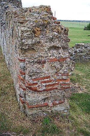
The fort walls were very strong, about 14.8 feet (4.5 m) high and 10 feet (3 m) thick at the bottom. The main gate faced north, towards the sea. Over time, the sea has washed away the north wall and parts of the east and west walls. What's left today are mostly the inner cores of the walls, made of flint and concrete. People also took stones from the fort to build other things nearby.
Outside the fort, there was a civilian settlement called a vicus. Much of this area has also been lost to the sea. Archaeologists found wells and signs of Roman buildings here.
Sadly, at least 10 baby burials have been found inside the fort. They were all babies, and some were found within the foundations of buildings. A local story says that the fort grounds are haunted by the sound of a crying baby.
The fort became part of a chain of forts called the Saxon Shore forts. These forts were built to defend against pirates. The fort at Reculver was abandoned around the 370s.
Medieval Reculver: Kings, Monks, and Trade
By the 7th century, Reculver was part of the Anglo-Saxon Kingdom of Kent. Many old coins have been found here, suggesting it was an important trading place on the coast. In 669 AD, King Ecgberht of Kent gave land for a monastery to be built on the Roman fort site. This monastery was dedicated to St Mary.
The monastery grew and became very rich. It controlled a large area of land. By the 10th century, the monastery and its land became royal property. Later, in 949, King Eadred gave them back to the archbishops of Canterbury.
In 1086, Reculver was mentioned in the Domesday Book. It was a "hundred," which was a local area for administration. The manor of Reculver was quite valuable. It included a church, farmland, a mill, and places for making salt. Many people lived there, including farmers and their families.
By the 1200s, Reculver was a very wealthy parish. The church building was made much bigger during the Middle Ages. This shows that Reculver was a busy town with many houses. In 1310, the Archbishop of Canterbury noted that the population of the parish was over 3,000 people. Because the parish was so large, some of its chapels, like those in Herne and on the Isle of Thanet, became separate parishes.
Decline and Loss to the Sea
Reculver's success in the Middle Ages was partly due to its location on the Wantsum Channel. This channel was a busy trade route. Reculver was even a member of the Cinque Port of Sandwich. However, the channel slowly filled up with silt. By about 1460, it was no longer open for trading ships. The first bridge was built across it in 1485 because ferries could no longer cross reliably.
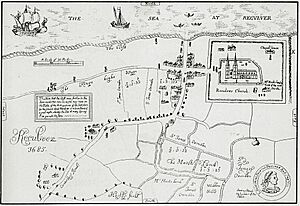
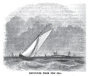
Reculver also suffered from coastal erosion. By 1540, the coastline had moved much closer to the town. The village was described as "poor and simple" in 1576. A map from around 1630 shows the church was only about 500 feet (150 m) from the shore. The sea kept eating away at the land. By the late 1700s, most of the village was abandoned. People moved to Hillborough, a nearby area within the same parish.
People tried to build sea defenses, but they didn't always work well. In September 1804, a high tide and strong winds destroyed five houses. In 1806, the sea started to take over the village. In 1807, local farmers removed the sea defenses. After that, the village was completely open to the sea's power.
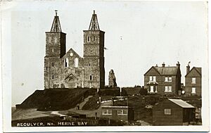
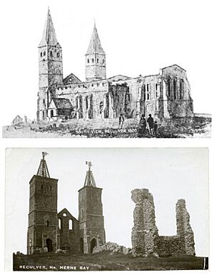
A decision was made to pull down the church in 1808. By March 1809, the cliff was only 12 feet (3.7 m) from the church. Demolition began in September of that year. However, Trinity House, which looks after lighthouses and navigation, stepped in. They wanted the church towers to be saved as a navigational aid for ships. In 1810, they bought the remaining towers for £100. They also built the first groynes (structures to stop erosion) to protect the cliff. The vicarage (the priest's house) was also abandoned. A new church was built in Hillborough and opened in 1813.
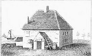
The old Hoy and Anchor Inn was destroyed by the sea. The abandoned vicarage was used as a temporary replacement. By 1809, a new Hoy and Anchor Inn was built. It was later renamed the King Ethelbert Inn.
Today, English Heritage looks after the church site and the sea defenses. The village itself has mostly disappeared. In 2000, a Millennium Cross was put up at the car park entrance. It was made using pieces of an old medieval cross from inside the church. It celebrates 2,000 years of Christianity.
Bouncing Bombs and World War II
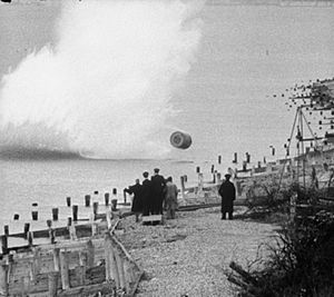
During the Second World War, the coastline east of Reculver was used to test special bombs. These were prototypes of Barnes Wallis's famous "bouncing bomb." This area was chosen because it was quiet. Also, the church towers were a clear landmark, and it was easy to get the bombs back from the shallow water.
Different versions of the bomb were tested here. These tests led to the "Upkeep" bomb. This bomb was used by the RAF's 617 Squadron in Operation Chastise. This mission is also known as the Dambuster raids. In May 1943, Lancaster bombers used these bombs to attack dams in Germany. On May 17, 2003, a Lancaster bomber flew over Reculver to remember the 60th anniversary of this event.
Two prototype bouncing bombs lay in the marshland until about 1977, when the Army removed them. Other prototypes were found in 1997. One is now in the Herne Bay Museum and Gallery. Others are on display at Dover Castle and the Spitfire & Hurricane Memorial Museum. In 2017, part of another inert (non-explosive) Upkeep bomb was found during beach work.
Governance
Reculver is part of an electoral ward (a local voting area) with the same name. This ward includes other nearby areas like Beltinge and Hillborough. It is part of the City of Canterbury district. The ward has one representative on Canterbury City Council. At the national level, Reculver is in the North Thanet parliamentary area.
Geography
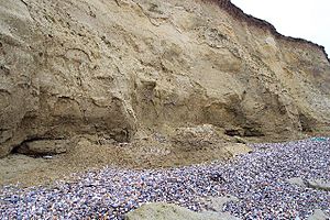
The ruins of the Roman fort and church at Reculver stand on a low hill. This hill is the last part of the Blean Hills that reaches the sea. The cliffs here show layers of rock that are about 55 million years old. These rocks are soft sandstones and clays.
These types of rocks are easily washed away by the sea. It is thought that the Roman fort was originally about 1 mile (1.6 km) from the sea to the north. But the cliffs are eroding at about 3.3 feet (1 m) per year. This erosion caused most of Reculver village to disappear by 1800.
There is a plan to manage this erosion. Some parts of the coastline, like the country park, will be allowed to erode naturally. But other parts, like the Roman fort and church, will be protected. New sea defenses were built in the 1990s, including covering the beaches around the church with large boulders.
The warmest time in Kent is July and August, with temperatures around 70°F (21°C). The coolest time is January and February, with temperatures around 34°F (1°C). Reculver, being on the coast, can sometimes be warmer than areas further inland. Kent gets less rain than the national average. A water desalination plant is planned for Reculver to help with water supplies during dry periods.
People of Reculver
In the 1801 census, there were 252 people in Reculver parish. This number stayed about the same until the 20th century. In 1931, the population was 829. In the summer, the number of people at Reculver can go up to over 1,000 because of holidaymakers.
The 2001 census showed 135 people living in Reculver and its nearby farms. Almost a quarter of them lived in caravans. Most people were born in the UK. The population was almost evenly split between females and males. Many people were working, and about 17.7% were retired. Christianity was the main religion.
Economy
In the Middle Ages, Reculver was a "limb" (a smaller part) of the Cinque Port of Sandwich. This meant it was involved in sea trade. It also had to provide ships and men for the king. In return, it got special benefits like not having to pay certain taxes. Reculver also had a weekly market on Thursdays and a yearly fair on September 1st.
Oysters from the nearby coast were famous for being very tasty. In 1867, an area of salt water was leased for breeding oysters and lobsters. Today, there is an oyster hatchery on the eastern side of Reculver.
In 1914, a company drilled a borehole at Reculver looking for coal, but they didn't find a workable amount.
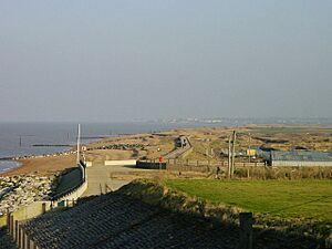
Today, Reculver is known for its static caravan parks. The first ones appeared after World War II. There's also a country park, the King Ethelbert public house, and a shop and cafe. Reculver is seen as an important place for green tourism. There are plans to develop it as a destination for walkers and cyclists.
Community Facilities
Reculver Church of England Primary School is next to the church at Hillborough. It also has a day nursery and an afterschool club. The closest school for older children is Herne Bay High School.
The nearest post office is in Beltinge. The closest doctor's surgery is between Bishopstone and Hillborough. The nearest general hospital is in Herne Bay. For emergencies, the closest hospital with an Accident and Emergency (A&E) department is in Margate. The Reculver and Beltinge Memorial Hall is the nearest community center.
Landmarks
Ruined Church of St Mary
The medieval towers of the ruined St Mary's Church are the most famous part of Reculver. They were added in the late 12th century to a church that was founded in 669 AD. The church was built inside the Roman fort, using stones from the old Roman buildings. In 692, the monastery's abbot became the Archbishop of Canterbury. King Eadberht II of Kent was buried inside the church in the 760s. The church was made much bigger over time, with the last additions in the 15th century. It had many old Anglo-Saxon features.
The church was mostly pulled down in 1809. This act has been called "vandalism" by some historians. Archaeologists have studied the church's history. Today, the ruins are looked after by English Heritage. The sea defenses that protect them were built in 1810 and are now maintained by the Environment Agency. Pieces of the old stone cross and two stone columns from the church are on display in Canterbury Cathedral.
The towers are sometimes called the "Twin Sisters." There's a story about how they got this name, but it's mostly a made-up tale from later times.
Reculver Country Park
Reculver Country Park is a nature reserve managed by Canterbury City Council and the Kent Wildlife Trust. It covers about 64 acres (26 hectares). It's a narrow strip of protected land along the cliff top, about 1.5 miles (2.4 km) long. It stretches from the Roman fort to Bishopstone Glen.
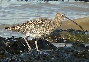
Most of the park is part of the Thanet Coast SSSI, a SPA, and a Ramsar site. It's also part of the Bishopstone Cliffs local nature reserve. In winter, you can see brent geese and wading birds like sanderlings. In summer, the largest colony of sand martins in Kent nests in the soft cliffs. You might also see fulmars and curlews.
The grasslands on the cliff top are rare wildflower meadows. They are home to butterflies and skylarks. You can also find nationally rare plants and insects here. The coastline is important for studying ancient rocks and fossils. The park won a Green Flag Award in 2005. Over 200,000 people visit it each year.
In 2011, an invasive species called the carpet sea squirt (also known as "marine vomit") was found in the area. This sea creature can cover other species and harm local fisheries.
Centre for Renewable Energy
A visitor center in Reculver Country Park re-opened in 2009. It's now called the Reculver Renewable Energy and Interpretation Centre. It uses a log burner, solar panels, and photovoltaic panels for electricity. There are displays about the history, geography, and wildlife of the area.
Transport
Reculver is at the end of a road called Reculver Lane. It's about 2 miles (3.2 km) from the main A299 road. In Roman times, there was a road connecting Reculver to Canterbury. Remains of a Roman road leading to the fort's east gate have been found.
In the 1800s, you could get to Reculver by coach from places like Upstreet. Later, hackney carriages were available from Herne Bay. Today, bus services connect Reculver with Herne Bay, Canterbury, Birchington, and Margate.
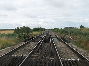
The closest train stations are at Herne Bay and Birchington-on-Sea. Both are on the Chatham Main Line, which runs between London and Ramsgate. The railway reached Herne Bay in 1861. Although a station for Reculver was proposed, it was never built.
Reculver has a long history of sea connections. The Roman fort had a harbor. In Anglo-Saxon times, its location on the Wantsum Channel made it a major trade route. The monastery might even have had its own ships. In the 17th century, an inlet was known as "The Old Pen," used as a harbor for ships. The King Ethelbert Inn's old name, "Hoy and Anchor," refers to hoys, a type of local merchant sailing ship.
Today, there is no public access to Reculver from the sea. However, the church towers are still a landmark for sailors. They help mark the division between different maritime rescue areas.
Religion
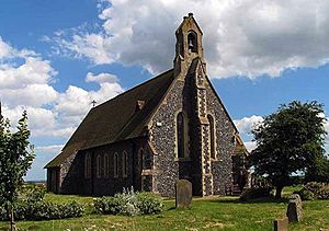
In the early 1800s, a new Anglican parish church was built in Hillborough. This replaced the old St Mary's Church at Reculver. The new church was also dedicated to St Mary. It was consecrated (officially opened for worship) on April 13, 1813. This first new church was small and simple. It was replaced by the current church, which was started in 1876 and opened in 1878.
The church built in 1876 was designed in the Gothic Revival style. It can seat about 100 people. It's a simple building, but it uses some stonework from the old church at Reculver. The old baptismal font in the church probably came from a chapel on the Isle of Thanet. A war memorial outside the church lists the names of 27 local people who died in the First World War and the Second World War.
Notable People
King Eadberht II of Kent was buried in the church at Reculver in the 760s. His tomb was in the south part of the church. People used to think it was the tomb of King Æthelberht I.
John Langton, who was a important official for King Edward I and King Edward II, was also a rector (a type of priest) of Reculver. So was Simon of Faversham, a philosopher from the 1300s.
Nicholas Tingewick, a doctor for King Edward I, was the first recorded owner of Brook, a place near Reculver. He was also a rector and later the first vicar of Reculver. He was known as the "best doctor for the king's health."
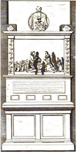
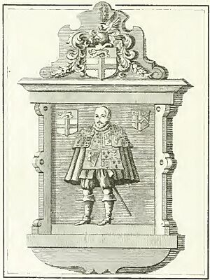
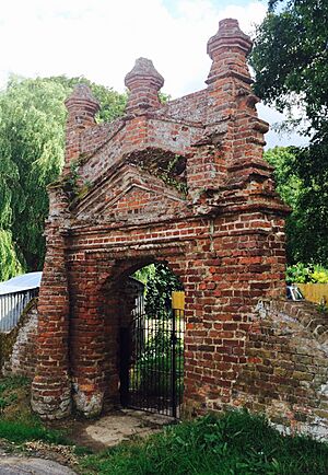
Brook later belonged to Sir Cavalliero Maycote. He was an important person in the courts of Queen Elizabeth I and King James I. He had a beautiful monument in the church at Reculver. It showed him, Lady Maycote, and their nine children kneeling. Today, Brook is Brook Farm, and you can still see a "very rustic Elizabethan affair" brick gateway from Maycote's home.
Ralph Brooke, an officer of arms (someone who deals with coats of arms and family histories), was buried inside the church in 1625. His monument showed him in his herald's coat.
Robert Hunt, who was the vicar of Reculver from 1595 to 1602, later became a minister in the English settlement at Jamestown, Virginia. He probably held the first known holy communion service in what is now the United States in 1607.
Barnabas Knell was vicar from 1602 to 1646. During the English Civil War, his son Paul Knell was a chaplain for the Royalist army.
Much of the land around Reculver in 1685 belonged to James Oxenden. He was a Member of Parliament for Kent for many years.
See also
 In Spanish: Reculver para niños
 | Jackie Robinson |
 | Jack Johnson |
 | Althea Gibson |
 | Arthur Ashe |
 | Muhammad Ali |


