Allamakee County, Iowa facts for kids
Quick facts for kids
Allamakee County
|
|
|---|---|
|
|
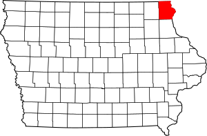
Location within the U.S. state of Iowa
|
|
 Iowa's location within the U.S. |
|
| Country | |
| State | |
| Founded | 1847 |
| Seat | Waukon |
| Largest city | Waukon |
| Area | |
| • Total | 659 sq mi (1,710 km2) |
| • Land | 639 sq mi (1,660 km2) |
| • Water | 20 sq mi (50 km2) 3.0% |
| Population
(2020)
|
|
| • Total | 14,061 |
| • Estimate
(2023)
|
14,074 |
| • Density | 21.337/sq mi (8.238/km2) |
| Time zone | UTC−6 (Central) |
| • Summer (DST) | UTC−5 (CDT) |
| Congressional district | 2nd |
Allamakee County is a county located in the northeastern part of Iowa, a state in the United States. It is the county furthest to the northeast in Iowa. In 2020, about 14,061 people lived here. The main town and county seat is Waukon.
Contents
History of Allamakee County
Allamakee County was officially created on February 20, 1847. People are not sure how the county got its name. Some believe it was named after a Native American chief. Others think it was named after an early trader named Allen Magee.
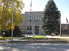
The first building used as the Allamakee County Courthouse was built in Waukon in 1861. Today, this old building is the Allamakee County Historical Museum. The current Allamakee County Court House was built much later, in 1940. Both courthouse buildings are important historical places. They are listed on the National Register of Historic Places.
Geography and Nature
Allamakee County covers a total area of about 659 square miles. Most of this area, about 639 square miles, is land. The remaining 20 square miles, or 3%, is water.
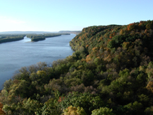
Many rivers flow through the county. The Upper Iowa River is in the northern part. The Yellow River is in the southern part. The Mississippi River forms the county's eastern border. These rivers are great for enjoying nature and outdoor activities. You can find many opportunities for fun in places like Yellow River State Forest.
Several smaller creeks also flow through the county. These include French Creek, Paint Creek, Norfolk Creek, Clear Creek, and Village Creek. All these creeks eventually flow into the mighty Mississippi River.
The land in Allamakee County is quite special and different from most of Iowa. Most of Iowa is flat because of glaciers. But Allamakee County is part of the "Driftless Area." This means it was not covered by ice during the last ice age. Because of this, the rivers here have carved deep, high-walled canyons into the ancient bedrock. This unique "Driftless Area" also includes parts of other nearby counties in Iowa.
Main Roads
Neighboring Counties
Allamakee County shares borders with several other counties:
- Houston County, Minnesota (to the north)
- Vernon County, Wisconsin (to the northeast)
- Crawford County, Wisconsin (to the east)
- Clayton County (to the south)
- Winneshiek County (to the west)
- Fayette County (to the southwest)
People and Population
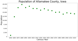
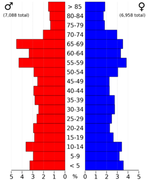
The population of Allamakee County has changed over the years. In 1850, only 777 people lived here. By 1900, the population grew to over 18,000. In 2020, the census counted 14,061 people. This means there were about 22 people living in each square mile.
2020 Census Information
The 2020 census showed that 14,061 people lived in Allamakee County. Most people, about 96.88%, said they belonged to one race. About 81.08% were non-Hispanic White. Other groups included Black, Hispanic, Native American, and Asian people. Some people also reported being of more than one race. There were 7,668 homes in the county, and 5,797 of them were lived in.
Cool Places to Visit
Allamakee County has several interesting places to explore:
- Effigy Mounds National Monument: This special place in the southeast corner of the county has ancient mounds shaped like animals. They were built by Native Americans long ago.
- Upper Mississippi River National Wildlife and Fish Refuge: This large refuge protects wildlife and fish along the Mississippi River.
- Driftless Area National Wildlife Refuge: This refuge is made up of small areas that protect rare and endangered plants and animals.
- Yellow River State Forest: This state park is open all year round. It's a great place for hiking, camping, and enjoying nature.
Local News and Media
You can find out what's happening in Allamakee County through these local newspapers:
- The Waukon Standard
- The Postville Herald-Leader
Towns and Communities
Cities
Here are the cities located in Allamakee County:
- Harpers Ferry
- Lansing
- New Albin
- Postville (part of this city is in another county)
- Waterville
- Waukon
Unincorporated Communities
These are smaller communities that are not officially cities:
Ghost Towns
These are places where towns once existed but are now abandoned:
City Sizes by Population
This table shows the population of the cities in Allamakee County, based on the 2020 census.
| Rank | City/Town/etc. | Type | Population (2020 Census) |
|---|---|---|---|
| 1 | † Waukon | City | 3,827 |
| 2 | Postville (partially in Clayton County) | City | 2,228 (2503 total) |
| 3 | Lansing | City | 968 |
| 4 | New Albin | City | 432 |
| 5 | Harpers Ferry | City | 262 |
| 6 | Waterville | City | 109 |
See also
 In Spanish: Condado de Allamakee para niños
 | Georgia Louise Harris Brown |
 | Julian Abele |
 | Norma Merrick Sklarek |
 | William Sidney Pittman |


