
Waukon, Iowa facts for kids
Quick facts for kids
Waukon, Iowa
|
|
|---|---|

Waukon City Hall in 2020
|
|

Location of Waukon within County and State
|
|

Detailed local map of Waukon
|
|
| Country | |
| State | |
| County | Allamakee |
| Township | Makee |
| Area | |
| • Total | 2.84 sq mi (7.35 km2) |
| • Land | 2.84 sq mi (7.35 km2) |
| • Water | 0.00 sq mi (0.00 km2) |
| Elevation | 1,237 ft (377 m) |
| Population
(2020)
|
|
| • Total | 3,827 |
| • Density | 1,349.44/sq mi (520.99/km2) |
| Time zone | UTC-6 (Central (CST)) |
| • Summer (DST) | UTC-5 (CDT) |
| ZIP code |
52172
|
| Area code(s) | 563 |
| FIPS code | 19-82740 |
| GNIS feature ID | 0462754 |
| Website | cityofwaukon.com |
Waukon is a city in Allamakee County, Iowa, United States. It is the main city and the county seat of Allamakee County. In 2020, about 3,827 people lived there.
Contents
History of Waukon
Waukon is likely named after Waukon Decorah. He was a leader of the Ho Chunk (Winnebago) people. He helped the U.S. during the 1832 Black Hawk War. Some say the city was named after his son, Chief John Waukon. The Winnebago people lived in this part of Iowa in the 1840s. Later, they had to move to Minnesota.
Early Settlers and Town Growth
The first white settler arrived in 1849. The town of Waukon was officially started in 1853. That same year, the Waukon Post Office opened. A courthouse was finished in 1861. The county seat, which is the main government town for the county, moved to Waukon in 1867. This happened after eight elections to decide where it should be. The town became an official city in 1883. Ryan Griffith was the first mayor of Waukon. He won the election in 1883 with everyone agreeing.
Railroad Connections
Waukon is about 16 miles from Waukon Junction, which is on the Mississippi River. But the train track between them was 33 miles long. It had to climb 600 feet through very rough land. The Waukon and Mississippi Railroad opened in 1877. It was first built as a "narrow gauge" line. This means the tracks were closer together than usual.
The Chicago and Northwestern company first controlled the line. But the Chicago, Milwaukee and St. Paul Railway quickly bought it. They made the tracks wider to the standard size. The train line did not have much traffic. Because of this, it was closed down in the late 1960s.
Iron Mining in Waukon
About 3 miles northeast of Waukon, there is a large amount of limonite, which is a type of iron ore. This area is called Iron Mine Hill. It is thought to hold about 10 million tons of ore. This spot is also the highest point in northeast Iowa.
The Waukon Iron Company started digging for ore here in 1899. They also built a plant to wash the ore. This plant could process 300 tons of ore in 10 hours. But it was hard to move the ore 3 miles to the train tracks. So, the mine did not do well.
A second attempt to mine the iron started in 1907. This time, the Missouri Iron Company had more money. They built a train connection in 1910. A new ore processing plant was finished in 1913. It could handle 350 to 400 tons of ore each day. About $225,000 was spent on this project. New machines for the plant even got patents.
In 1916, this mine became the main mine for the new Mississippi Valley Iron Company. In 1917, the mine produced over 22,000 tons of ore. But in 1918, it closed because of World War I. The mine never reopened after that. Its equipment was sold for scrap metal in 1937. Today, Iron Mine Drive and Allamakee Street cross near where these old mines were.
Geography of Waukon
Waukon is where the north branch of Paint Creek begins. It is also just south of where Village Creek starts. The city is on the western edge of the Driftless Area of northeast Iowa. This area has many deep valleys.
The town sits on a flat area. Underneath it is a type of rock called Galena Limestone. There are many sinkholes in this flat area south of Waukon. A "sinkhole" is a hole in the ground that opens up when the rock underneath collapses. To the north, more Galena Limestone is found under Iron Hill.
The United States Census Bureau says that Waukon covers about 2.82 square miles (7.35 square kilometers). All of this area is land.

Climate in Waukon
Waukon has a climate with warm summers and cold winters. The weather changes a lot throughout the year.
| Climate data for Waukon, Iowa (1991–2020 normals, extremes 1934–present) | |||||||||||||
|---|---|---|---|---|---|---|---|---|---|---|---|---|---|
| Month | Jan | Feb | Mar | Apr | May | Jun | Jul | Aug | Sep | Oct | Nov | Dec | Year |
| Record high °F (°C) | 56 (13) |
60 (16) |
82 (28) |
91 (33) |
92 (33) |
96 (36) |
106 (41) |
100 (38) |
99 (37) |
91 (33) |
75 (24) |
63 (17) |
106 (41) |
| Mean daily maximum °F (°C) | 24.0 (−4.4) |
29.0 (−1.7) |
41.5 (5.3) |
55.7 (13.2) |
67.5 (19.7) |
77.3 (25.2) |
81.3 (27.4) |
79.0 (26.1) |
72.2 (22.3) |
58.7 (14.8) |
42.5 (5.8) |
29.4 (−1.4) |
54.8 (12.7) |
| Daily mean °F (°C) | 16.2 (−8.8) |
20.5 (−6.4) |
32.2 (0.1) |
45.0 (7.2) |
56.6 (13.7) |
67.5 (19.7) |
71.5 (21.9) |
69.1 (20.6) |
61.4 (16.3) |
48.7 (9.3) |
34.5 (1.4) |
22.2 (−5.4) |
45.5 (7.5) |
| Mean daily minimum °F (°C) | 8.4 (−13.1) |
12.0 (−11.1) |
22.8 (−5.1) |
34.3 (1.3) |
45.7 (7.6) |
57.7 (14.3) |
61.6 (16.4) |
59.3 (15.2) |
50.7 (10.4) |
38.7 (3.7) |
26.5 (−3.1) |
15.0 (−9.4) |
36.1 (2.3) |
| Record low °F (°C) | −31 (−35) |
−34 (−37) |
−21 (−29) |
2 (−17) |
24 (−4) |
32 (0) |
40 (4) |
38 (3) |
25 (−4) |
15 (−9) |
−13 (−25) |
−27 (−33) |
−34 (−37) |
| Average precipitation inches (mm) | 1.23 (31) |
1.25 (32) |
2.03 (52) |
4.06 (103) |
4.66 (118) |
5.92 (150) |
4.73 (120) |
4.70 (119) |
3.92 (100) |
2.85 (72) |
2.27 (58) |
1.57 (40) |
39.19 (995) |
| Source: NOAA | |||||||||||||
People of Waukon
| Waukon historical population | ||
|---|---|---|
| Year | Pop. | ±% |
| 1880 | 1,350 | — |
| 1890 | 1,610 | +19.3% |
| 1900 | 2,153 | +33.7% |
| 1910 | 2,025 | −5.9% |
| 1920 | 2,359 | +16.5% |
| 1930 | 2,526 | +7.1% |
| 1940 | 2,972 | +17.7% |
| 1950 | 3,158 | +6.3% |
| 1960 | 3,639 | +15.2% |
| 1970 | 3,883 | +6.7% |
| 1980 | 3,983 | +2.6% |
| 1990 | 4,019 | +0.9% |
| 2000 | 4,131 | +2.8% |
| 2010 | 3,897 | −5.7% |
| 2020 | 3,827 | −1.8% |
| Source: Source: |
||
Population in 2020
In 2020, Waukon had 3,827 people. This means there were about 1,349 people per square mile. Most people (95.5%) were White. About 0.7% were Black or African American. A small number were Native American or Asian. Some people were from two or more races (2.2%). About 2.7% of the population were Hispanic or Latino.
Population in 2010
In 2010, there were 3,897 people living in Waukon. There were 1,781 households, which are groups of people living in one home. About 1,008 of these were families. The city had about 1,382 people per square mile.
Most people (98.4%) were White. A small number were African American, Native American, or Asian. About 1.4% of the people were Hispanic or Latino.
About 24.3% of households had children under 18. Many households (43%) were married couples. About 37.5% of all households were single people living alone. About 18% of homes had someone 65 years or older living alone. The average age in the city was 45.8 years. About 20.4% of people were under 18. About 24% were 65 or older.
Parks and Recreation
Waukon has a Family Aquatic Area. This is a swimming pool that is a big attraction in the city's park. The park also has a small lake and playgrounds. There is a campground for people who want to stay overnight. You can also find softball and other sports fields there.
Education
The Allamakee Community School District runs the public schools in Waukon. These include two elementary schools, a middle school, and a high school. There is also a private elementary school in Waukon. It is connected to a Catholic church.
Media
Newspaper
- Waukon Standard
Radio
- KNEI-FM 103.5 Bluff Country
Notable People from Waukon
Many interesting people have come from Waukon:
- Dudley W. Adams: A person who studied plants and helped farmers.
- Mark Farley: The head football coach at the University of Northern Iowa.
- Bess Goodykoontz: An educator and government official.
- Gregory D. Hager: A famous professor at Johns Hopkins University.
- Isaiah H. Hedge: A doctor who was against slavery and helped start Bates College.
- Levi M. Hubbell: A politician and businessman.
- Hugh Kidder: An officer in the United States Marine Corps during World War II.
- Edward P. Ney: A famous professor at the University of Minnesota.
- Cletus F. O'Donnell: A Roman Catholic bishop.
- Michael Osterholm: A scientist who studies public health and diseases.
- Joseph Taggart: A member of the U.S. House of Representatives.
Images for kids
-
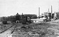
The Mississippi Valley Iron Co. ore processing plant in 1918.
-
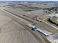
Waukon airport
-
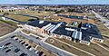
Waukon high school, middle, and elementary school


See also
 In Spanish: Waukon (Iowa) para niños
