
Annerley facts for kids
Quick facts for kids AnnerleyBrisbane, Queensland |
|||||||||||||||
|---|---|---|---|---|---|---|---|---|---|---|---|---|---|---|---|

Ipswich Road near the junction of Annerley Road
|
|||||||||||||||

Annerley
Location in Queensland
|
|||||||||||||||
| Population | 11,891 (2021 census) | ||||||||||||||
| • Density | 4,250/km2 (11,000/sq mi) | ||||||||||||||
| Postcode(s) | 4103 | ||||||||||||||
| Elevation | 48 m (157 ft) | ||||||||||||||
| Area | 2.8 km2 (1.1 sq mi) | ||||||||||||||
| Time zone | AEST (UTC+10:00) | ||||||||||||||
| Location | 6.2 km (4 mi) S of Brisbane CBD | ||||||||||||||
| LGA(s) | City of Brisbane (Coorparoo Ward, Tennyson Ward) |
||||||||||||||
| State electorate(s) |
|
||||||||||||||
| Federal Division(s) | Moreton | ||||||||||||||
|
|||||||||||||||
Annerley is a busy suburb in Brisbane, Queensland, Australia. It is located about 6.2 kilometres (3.9 miles) south of the Brisbane city centre. In 2021, Annerley was home to 11,891 people.
Contents
Exploring Annerley
Where is Annerley Located?
Annerley sits on a high ridge, offering some great views of the city. For a long time, it was a bit run-down. But now, many of its old "Queenslander" homes have been beautifully fixed up. This means Annerley has a cool mix of old and new houses.
The suburb has many apartment buildings and places to eat. Ipswich Road is a major road that runs through Annerley. It's one of Brisbane's main roads heading south. Years ago, electric trams used to run along Ipswich Road until 1969.
The spot where Ipswich Road meets Annerley Road is known as Annerley Junction. This area gave its name to the local primary school, Junction Park State School.
A Look Back in Time

Annerley was first used for dairy farms. Over time, it grew into the suburb we know today.
How Annerley Grew
One of the first areas sold for homes was the "St Kilda Estate" in 1866. The Junction Hotel also opened that year. Many other land sales happened in the late 1800s. These sales helped Annerley grow from farmland into a place where people lived.
The Annerley Post Office
Around 1880, a small post office opened in the area. It was first called Boggo Post Office. Later, in November 1892, it was renamed Annerley Post Office. The name "Annerley" was suggested by Digby Denham, who later became a Premier of Queensland. He named it after a town in England.
Important Community Buildings
Annerley has many historic churches and community buildings. These places have played a big part in the suburb's history.
St John's Presbyterian Church

The first Thompson Estate Presbyterian Church opened on 16 May 1886. It was a simple wooden building. In 1929, a larger church was built next to it. This new church was designed by George Trotter and cost £3,500. It could seat 300 people. The original building became the church hall.
Shire of Stephens Office

In 1886, Annerley became the main town for the Stephens Division. This division later became the Shire of Stephens in 1903. A "shire" is like a local government area. The shire offices were on Ipswich Road. When Annerley became part of the City of Brisbane in 1925, the old shire office building was moved and became a house on Ealing Street.
St Philip's Anglican Church
St Philip's Anglican Church was first opened in 1886. It was damaged by a severe storm in 1905 but was rebuilt. The church was destroyed by fire in 1954. The current church building was finished in 1955. It is now a heritage-listed building in Brisbane.
Thompson Estate Methodist Church
A Wesleyan Methodist Church opened on Cornwall Street in 1888. It was designed by Mark Taylor and William Richer. In 1973, this church became an Apostolic Church.
Annerley Congregational Church
A Congregational Church community started in the Cracknell Road area. A small church building was moved to Cracknell Road in 1899. A new, larger church was built in 1925. In 1977, this church joined with other churches to form the Uniting Church in Australia. It is now known as the Brisbane Fijian Uniting Church.
Annerley Methodist Church
_and_new_(right)_Methodist_Church_at_Ipswich_Road,_Annerley,_1917.jpg)
A Primitive Methodist Church opened on Ipswich Road in 1890. A new church building was built next to the old one in 1917. The old church was later taken down. In 1946, a fire damaged the church hall, but the main church was saved. A new brick church was built later.
Annerley Church of Christ
A Bible school started in Annerley in 1913. A church group was formed later that year. In 1920, an old church building from another town was moved to Annerley Road to become the first Annerley Church of Christ. A new, modern church building was opened in 1964.
Mary Immaculate Church

The first Mary Immaculate Church was a temporary wooden building built in 1914. In 1932, a new, grander church was built. This church helped provide jobs for 30 men during the Great Depression. It has a unique French Gothic style with a tall bell tower. The church is an important and historic building in Annerley. It is also listed on the Brisbane Heritage Register.
Annerley Baptist Church
The Annerley Baptist Church opened in 1935 on Ipswich Road. The church building itself was moved from Fairfield, where it had been since 1865. The church grew over the years, starting new Sunday schools and churches in nearby areas like Tarragindi and Salisbury. A new brick church building was opened in 1965.
Annerley Library

The Annerley public library first opened in 1957. It was designed by architect James Birrell and is a heritage-listed building.
Our Lady's College
In 1964, the Sisters of St Joseph opened Our Lady's College, a high school for girls. Since 1976, it has been run by Brisbane Catholic Education.
Annerley's People
Annerley is a diverse suburb. In 2021, it had a population of 11,891 people. The average age in Annerley is 32 years old. Most people (62.1%) were born in Australia. Other common birthplaces include India, New Zealand, and England. English is the main language spoken at home, but many other languages are also spoken, such as Mandarin, Greek, and Vietnamese.
Heritage Sites in Annerley


Annerley has many places that are important to its history and are listed on the heritage-listed register. These include:
- 260 Annerley Road: Hefferan Park Air Raid Shelter
- 391 Annerley Road: Ingleside, the old home of Digby Denham, a former Premier of Queensland
- 151 Cornwall Street: Apostolic church (which used to be a Methodist church)
- 29 Cracknell Road: Brisbane Fijian Uniting Church
- 158 Dudley Street: Former Annerley Army Reserve Depot
- 15 Ealing Street: Former Stephens Shire office
- 413 Ipswich Road: Tram substation (now a hotel restaurant)
- 444 Ipswich Road: Police Station (still in use)
- 448 Ipswich Road: Annerley Library & Community Centre
- 616 Ipswich Road: Mary Immaculate Catholic Church
- 23 King Street: St John's Presbyterian Church
- 50 Waldheim Street: Junction Park State School
Schools in Annerley
Annerley has several schools for young people:
- Junction Park State School: This is a government primary school for students from Prep to Year 6. It is located at 50 Waldheim Street. It also has a special education program.
- Mary Immaculate Primary School: This is a Catholic primary school for students from Prep to Year 6. It is located at 616 Ipswich Road. The school's nickname is Mary Mac.
- Our Lady's College: This is a Catholic high school for girls from Year 7 to Year 12. It is located at 15 Chester Road.
There isn't a government high school right in Annerley. The closest one is Yeronga State High School in the nearby suburb of Yeronga.
Community Places

Annerley has many places for the community to gather:
- The Brisbane City Council runs the Annerley public library at 448 Ipswich Road.
- Mary Immaculate Church is a Catholic church at the corner of Ipswich Road and Ferndale Street.

St Philip's Anglican Church is at 115 Cornwall Street. The Brisbane group of the Mar Thoma Church also holds services there.
- St John's Presbyterian Church is at 23 King Street and holds Sunday services.
- Brisbane Fijian Uniting Church is at 29 Cracknell Road. It holds Sunday services in English and Fijian.
- Annerley Church of Christ holds Sunday services in English, Spanish, and Farsi at 459 Annerley Road.
- Annerley Baptist Church is at 560 Ipswich Road. The Westside Tongan Church also holds services there.
- Annerley Apostolic Church is at 151 Cornwall Street.
Fun Events in Annerley

The Annerley Junction area hosts several yearly events. The first "Junction Fair" Christmas event was held in 2012. The first "Junction Jumble Sale" was also held in 2012.
The annual Annerley Junction Fest now takes place on the second Saturday of October. It includes a special area for children, fashion shows, an art show, food and market stalls, and even a short film competition. You can find more information at junctionfest.com.au.
Famous People from Annerley
Annerley has been home to some notable people:
- Digby Denham: He was the 18th Premier of Queensland and lived at Ingleside on Annerley Road.
- Ken Fletcher: An Australian tennis player who won many Grand Slam titles in doubles and mixed doubles. He was born in Annerley Junction.
- Ainsley Gotto: A political secretary and interior designer, born here in 1946.
- Hugh Lunn: A journalist and writer who lived at 484 Ipswich Road in the "Lunns for Buns" cake shop, which became famous in his book "Over the Top with Jim".
See Also
- List of Brisbane suburbs
Images for kids
-
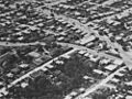
Aerial view of Annerley around 1934
-
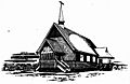
Cracknell Road Congregational Church, designed by Brenan Gargett, 1925
-
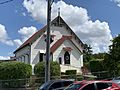
Apostolic Church (formerly Methodist Church), 2020


,_Annerley,_2020_02.jpg)
