Ansted, West Virginia facts for kids
Quick facts for kids
Ansted, West Virginia
|
||
|---|---|---|
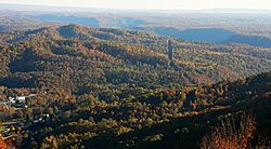
View from the top of Gauley Mountain, looking over the town of Ansted towards the New River Gorge Bridge nearly six miles away.
|
||
|
||
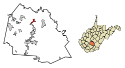
Location of Ansted in Fayette County, West Virginia.
|
||
| Country | United States | |
| State | West Virginia | |
| County | Fayette | |
| Area | ||
| • Total | 1.66 sq mi (4.31 km2) | |
| • Land | 1.66 sq mi (4.30 km2) | |
| • Water | 0.00 sq mi (0.01 km2) | |
| Elevation | 1,319 ft (402 m) | |
| Population
(2010)
|
||
| • Total | 1,404 | |
| • Estimate
(2019)
|
1,305 | |
| • Density | 786.14/sq mi (303.51/km2) | |
| Time zone | UTC-5 (Eastern (EST)) | |
| • Summer (DST) | UTC-4 (EDT) | |
| ZIP code |
25812
|
|
| Area code(s) | 304 | |
| FIPS code | 54-01996 | |
| GNIS feature ID | 1534968 | |
Ansted is a small town in Fayette County, West Virginia, located in the U.S. state of West Virginia. In 2010, about 1,404 people lived there. The town sits high up on cliffs along U.S. Route 60. This road is part of the Midland Trail, a special scenic route. Ansted overlooks the New River far below, near a spot called Hawks Nest.
Contents
History of Ansted
Early Settlers and Fayette County
Long ago, the area where Ansted is now was a hunting ground for Native American tribes. In the late 1700s, some Baptists settled here. They built the Hopewell Baptist Church.
In 1831, Fayette County was created. It was named after the Marquis de la Fayette, a French hero of the American Revolutionary War. The first county court met near Ansted's current location. This area was then known as Mountain Cove. Over time, it had other names like Woodville and New Haven.
Ansted During the Civil War
During the American Civil War, Fayette County was important for both the Union and Confederate armies. A nearby bridge at Gauley Bridge was fought over many times. It was even burned down, which people remembered for a long time.
In the winter of 1861–62, Union soldiers from Illinois stayed in what is now Ansted. Confederate General Robert E. Lee also had his headquarters nearby. It was there that he met his famous horse, "Traveller". Even though many local people supported the Confederacy, this area became part of the new State of West Virginia in 1863. Some local stories tell of soldiers and local girls falling in love and marrying after the war.
Railroads, Coal, and Ansted's Founding
Around 1872, the Chesapeake & Ohio Railway built new train tracks through the New River valley. This connected the area to the Ohio River and Mississippi River. The last spike for this part of the railroad was placed near Ansted in 1873.
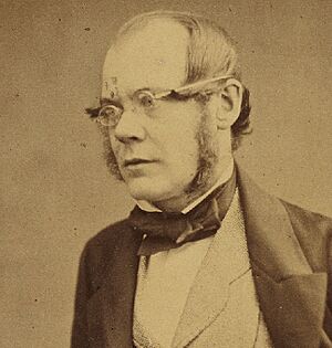
In 1873, the town of Ansted was officially created. It was named after Dr. David T. Ansted, a British geologist and scientist. He had explored the area in 1853 and found rich deposits of high-quality bituminous coal.
A former Confederate officer, Colonel George W. Imboden, helped plan the town. He bought land with Dr. Ansted and started a coal company. Colonel Imboden became Ansted's first mayor. His home, "Contentment", is now a historical museum.
Another important person was William Nelson Page. He was an engineer and mining manager. He helped develop West Virginia's coal fields. Page also helped build the Virginian Railway. He lived in a large mansion in Ansted and also served as the town's mayor for 10 years. Two towns, Page and Pageton, were named after him.
From Railroads to Tourism
Ansted had train service from 1874 until 1972. Mine owners first built a small railroad to carry coal. Later, the Chesapeake and Ohio Railway (C&O) bought and improved it. This train line was very steep. Passenger service ran until the 1930s, and freight trains stopped in 1972. The tracks were then removed.
In the 1930s, a large tunnel was built under Hawks Nest to create hydroelectric power. Many workers dug through rock containing silica. Sadly, hundreds of workers became sick with a lung disease called silicosis because they didn't have protective gear. This event, known as the Hawks Nest Tunnel Disaster, led to new laws about worker safety and compensation.
Today, the Ansted–Hawks Nest Rail Trail follows the old train route. It's about 2.2 miles long and offers great views of the New River Gorge. You can even take an aerial tram from Hawks Nest Lodge to the end of the trail.
Historical Sites and Attractions
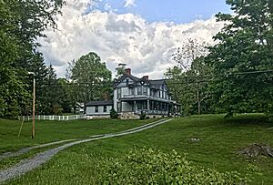
- Contentment Historical Complex: This is the old home of Angie and George Imboden. It's now a museum and the home of the Fayette County Historical Society. It has a museum and a restored old schoolhouse.
- Page-Vawter House: This grand mansion belonged to William and Emma Page. It's still a private home and is listed on the National Register of Historic Places.
- Halfway House: This building was once Tyree's Tavern. It served as a headquarters for Union soldiers during the Civil War.
- African American Heritage Family-Tree Museum: This museum helps African Americans learn about their family history.
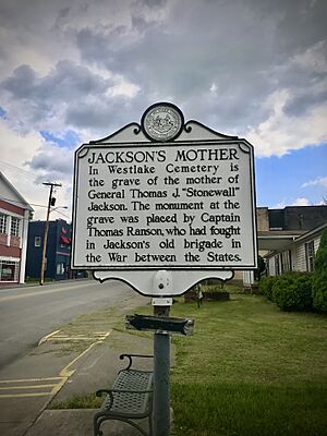
- Westlake Cemetery: Here you can find the grave of Julia Neale Jackson, who was the mother of Confederate General Thomas Stonewall Jackson.
- Hawks Nest State Park: This park is right in Ansted. It has a small museum, a gift shop, and an aerial tram that takes you down to the New River Gorge. There are also amazing viewpoints like "Lover's Leap".
- Midland Trail: U.S. Route 60 goes through Ansted and is part of this National Scenic Byway.
Ansted also hosts fun events like the Country Roads Festival in September and the Festival of Lights during Christmas. In the late 1990s, Ansted even hosted a Street Luge competition on Gauley Mountain. There's also a quirky attraction called the Mystery Hole, where strange things are said to happen!
In the early 2000s, a large flagpole and American Flag were built in town. In 2007, a war memorial was added to honor local military veterans.
Geography
Ansted is located at 38°8′10″N 81°6′7″W / 38.13611°N 81.10194°W. The town covers about 1.67 square miles (4.31 square kilometers). Most of this area is land, with a very small part being water.
Population Facts
| Historical population | |||
|---|---|---|---|
| Census | Pop. | %± | |
| 1900 | 1,090 | — | |
| 1910 | 1,030 | −5.5% | |
| 1920 | 1,178 | 14.4% | |
| 1930 | 1,404 | 19.2% | |
| 1940 | 1,422 | 1.3% | |
| 1950 | 1,543 | 8.5% | |
| 1960 | 1,511 | −2.1% | |
| 1970 | 1,511 | 0.0% | |
| 1980 | 1,952 | 29.2% | |
| 1990 | 1,643 | −15.8% | |
| 2000 | 1,576 | −4.1% | |
| 2010 | 1,404 | −10.9% | |
| 2019 (est.) | 1,305 | −7.1% | |
| U.S. Decennial Census | |||
In 2010, Ansted had 1,404 people living in 589 households. The average household had about 2.29 people. The population density was about 845.8 people per square mile.
Most of the people in Ansted were White (96.7%). About 2.7% were African American. The average age in the town was 47 years old. About 19.6% of residents were under 18, and 23.2% were 65 or older.
Notable People
- Sheriff Blake, a professional baseball pitcher.
- Tom Pridemore, a politician and football player.
See also
 In Spanish: Ansted (Virginia Occidental) para niños
 | Jewel Prestage |
 | Ella Baker |
 | Fannie Lou Hamer |


