
Antlers, Oklahoma facts for kids
Quick facts for kids
Antlers, Oklahoma
Kuniotubbee (Choctaw)
|
|
|---|---|

Antlers historic train station
|
|
| Nickname(s):
Deer Capital of the World
|
|

Location of Antlers, Oklahoma
|
|
| Country | United States |
| State | Oklahoma |
| County | Pushmataha |
| Area | |
| • Total | 3.13 sq mi (8.09 km2) |
| • Land | 3.11 sq mi (8.05 km2) |
| • Water | 0.02 sq mi (0.04 km2) |
| Elevation | 509 ft (155 m) |
| Population
(2020)
|
|
| • Total | 2,221 |
| • Density | 714.38/sq mi (275.86/km2) |
| Time zone | UTC-6 (Central (CST)) |
| • Summer (DST) | UTC-5 (CDT) |
| ZIP code |
74523
|
| Area code(s) | 580 |
| FIPS code | 40-02250 |
| GNIS feature ID | 2409716 |
Antlers is a city in Oklahoma, United States. It is the main city and county seat of Pushmataha County. In 2020, about 2,221 people lived there. The city got its name from a local spring where deer often gathered. Hunters would nail deer antlers to a tree near the spring, making it a famous landmark.
Contents
Discovering Antlers' Past
Early Inhabitants and Cultures
Long ago, people lived in the area where Antlers is today. They left behind arrowheads and other signs of their life. These early people often settled on hills for safety and health.
A very important settlement called Spiro Mounds was active nearby from the 800s to the 1400s. This was part of the Mississippian culture, which was based along the Mississippi River. Leaders from Spiro Mounds controlled the Antlers area and much of southeastern Oklahoma. They had a large trading network across the continent.
Later, the historic Caddo Indians lived in this region. They were descendants of the Mississippians. The Caddo people moved around a lot, hunting, fishing, and gathering plants.
Choctaw Nation and New Settlements
In 1832, the United States gave these lands to the Choctaw Indians through the Treaty of Dancing Rabbit Creek. This happened as the Choctaw and other Five Civilized Tribes (Muskogee, Cherokee, Chickasaw, and Seminole) were forced to move from their original homes in the southeastern U.S.
The Choctaw set up new communities in their new territory. However, more settlers soon started moving onto their land. During the American Civil War, many Choctaw sided with the Confederate States of America. They hoped to gain an independent Native American state if the Confederacy won.
The Railroad Arrives
In the 1880s, the "Frisco" railroad built a line through the Choctaw Nation. This railroad connected Fort Smith, Arkansas with Paris, Texas. The railroad needed to build stations every few miles. These stations helped new towns grow.
Antlers was chosen as a station stop because of its fresh spring water. The railroad was the main way to travel through the area. It ran passenger trains until the 1960s. Later, new highways like U.S. Highway 271 and the Indian Nation Turnpike were built. The Frisco Railroad stopped all operations in 1981.
How Antlers Got Its Name
The United States Post Office opened in Antlers on August 26, 1887. The town's name comes from a story told by an early settler, Colonel Victor M. Locke, Jr. A hunter once killed a large deer near the spring. He nailed its antlers to a tree as a challenge to other hunters. Soon, many antlers covered the tree. Railroad officials saw this and named the new station "Antlers."
Becoming a Town and Statehood
In the 1890s, the U.S. government set up Recording Districts in the Indian Territory. Antlers became the center of Recording District #24. This meant it had a U.S. Court to help settlers with legal matters. A large wooden courthouse was built.
To prepare for Oklahoma to become a state, the U.S. government surveyed and mapped Antlers in 1901. This allowed people to officially own their homes and land.
When Oklahoma became a state on November 16, 1907, the tribal governments were changed. Land was divided among individual tribal members. This led to Native Americans losing much of their land. Antlers also lost its federal court, and many jobs left the town.
Antlers as a Resort Town
For many years, Antlers was a popular resort town. It was a gateway to the Kiamichi Mountains. Tourists came to fish, hunt, and relax. Many visitors came from Paris, Texas.
The Great Tornadoes
On April 12, 1945, a very strong tornado hit Antlers. It destroyed many homes and businesses. Sixty-seven people died, and over 300 were hurt. Antlers High School became a place to care for the injured. The historic St. Agnes Academy for Choctaw Indians was also destroyed.
Scientists later called this an F5 tornado, the strongest kind. People thought two tornadoes hit, but it was one very wide and powerful funnel cloud. Another serious tornado struck Antlers in April 1954, causing 40 deaths.
Changes in Modern Times
After 1945, Antlers grew and changed like other U.S. towns. Homes got air conditioning and televisions. People started spending more time indoors for entertainment.
In 1975, a new shopping area called East Town Village opened. This caused many stores to leave the historic downtown. Also, Wal-Mart stores offered more choices and lower prices, which affected local businesses.
Recently, there have been efforts to bring back the historic feel of downtown Antlers. Many old buildings have strong brick walls and unique fronts. The town is working to restore their original look.
The Antlers Frisco Depot and Antlers Spring are now on the National Register of Historic Places. The depot, built in 1913, had separate waiting rooms for white and black passengers. This shows the racial segregation that was common at the time. You can learn more about Antlers' history at the Pushmataha County Historical Society.
Exploring Antlers' Location

Antlers covers about 2.7 square miles (7 square kilometers) of land.
The city's center is located where two different watersheds meet. Rain in the northeast part of town flows into creeks that go north to the Kiamichi River. This area has rocky soil. Water in other parts of town flows south into Beaver Creek, which also leads to the Kiamichi River. This soil is sandy. Standpipe Hill, which is higher than downtown, offers views of the Kiamichi River valley.
Antlers' Weather
Antlers has a humid subtropical climate. This means it has hot, humid summers and mild winters. The hottest temperature ever recorded in Antlers was 116°F (47°C) on August 10, 1936. The coldest was -10°F (-23°C) on February 2, 1951.
| Climate data for Antlers, Oklahoma, 1991–2020 normals, extremes 1918–present | |||||||||||||
|---|---|---|---|---|---|---|---|---|---|---|---|---|---|
| Month | Jan | Feb | Mar | Apr | May | Jun | Jul | Aug | Sep | Oct | Nov | Dec | Year |
| Record high °F (°C) | 84 (29) |
90 (32) |
93 (34) |
96 (36) |
101 (38) |
107 (42) |
112 (44) |
116 (47) |
110 (43) |
102 (39) |
88 (31) |
83 (28) |
116 (47) |
| Mean maximum °F (°C) | 72.3 (22.4) |
77.2 (25.1) |
82.6 (28.1) |
85.5 (29.7) |
90.3 (32.4) |
94.7 (34.8) |
100.3 (37.9) |
100.5 (38.1) |
96.6 (35.9) |
89.0 (31.7) |
80.3 (26.8) |
73.7 (23.2) |
101.9 (38.8) |
| Mean daily maximum °F (°C) | 52.4 (11.3) |
57.2 (14.0) |
64.7 (18.2) |
72.9 (22.7) |
80.0 (26.7) |
87.8 (31.0) |
92.8 (33.8) |
93.3 (34.1) |
86.4 (30.2) |
76.0 (24.4) |
63.7 (17.6) |
54.5 (12.5) |
73.5 (23.0) |
| Daily mean °F (°C) | 40.4 (4.7) |
45.1 (7.3) |
52.5 (11.4) |
60.9 (16.1) |
69.7 (20.9) |
77.8 (25.4) |
81.8 (27.7) |
81.4 (27.4) |
74.1 (23.4) |
62.9 (17.2) |
51.3 (10.7) |
42.8 (6.0) |
61.7 (16.5) |
| Mean daily minimum °F (°C) | 28.5 (−1.9) |
32.9 (0.5) |
40.3 (4.6) |
48.8 (9.3) |
59.3 (15.2) |
67.7 (19.8) |
70.7 (21.5) |
69.4 (20.8) |
61.8 (16.6) |
49.8 (9.9) |
39.0 (3.9) |
31.1 (−0.5) |
49.9 (10.0) |
| Mean minimum °F (°C) | 13.8 (−10.1) |
18.1 (−7.7) |
22.5 (−5.3) |
31.9 (−0.1) |
42.4 (5.8) |
56.3 (13.5) |
62.7 (17.1) |
60.2 (15.7) |
46.9 (8.3) |
32.8 (0.4) |
22.6 (−5.2) |
17.1 (−8.3) |
10.9 (−11.7) |
| Record low °F (°C) | −9 (−23) |
−10 (−23) |
8 (−13) |
24 (−4) |
31 (−1) |
45 (7) |
50 (10) |
49 (9) |
36 (2) |
19 (−7) |
7 (−14) |
−5 (−21) |
−10 (−23) |
| Average precipitation inches (mm) | 2.86 (73) |
2.90 (74) |
4.05 (103) |
4.36 (111) |
6.25 (159) |
4.33 (110) |
3.35 (85) |
3.09 (78) |
3.89 (99) |
4.85 (123) |
3.88 (99) |
4.11 (104) |
47.92 (1,218) |
| Average snowfall inches (cm) | 0.0 (0.0) |
0.3 (0.76) |
0.0 (0.0) |
0.0 (0.0) |
0.0 (0.0) |
0.0 (0.0) |
0.0 (0.0) |
0.0 (0.0) |
0.0 (0.0) |
0.0 (0.0) |
0.0 (0.0) |
0.0 (0.0) |
0.3 (0.76) |
| Average precipitation days (≥ 0.01 in) | 5.8 | 6.5 | 8.4 | 7.9 | 9.3 | 7.8 | 6.4 | 5.9 | 6.2 | 6.7 | 6.0 | 6.6 | 83.5 |
| Average snowy days (≥ 0.1 in) | 0.1 | 0.0 | 0.1 | 0.0 | 0.0 | 0.0 | 0.0 | 0.0 | 0.0 | 0.0 | 0.0 | 0.0 | 0.2 |
| Source 1: NOAA | |||||||||||||
| Source 2: National Weather Service | |||||||||||||
People of Antlers
Population Trends
| Historical population | |||
|---|---|---|---|
| Census | Pop. | %± | |
| 1910 | 1,273 | — | |
| 1920 | 1,842 | 44.7% | |
| 1930 | 2,246 | 21.9% | |
| 1940 | 3,254 | 44.9% | |
| 1950 | 2,506 | −23.0% | |
| 1960 | 2,085 | −16.8% | |
| 1970 | 2,685 | 28.8% | |
| 1980 | 2,989 | 11.3% | |
| 1990 | 2,524 | −15.6% | |
| 2000 | 2,552 | 1.1% | |
| 2010 | 2,453 | −3.9% | |
| 2020 | 2,221 | −9.5% | |
| U.S. Decennial Census | |||
In 2010, Antlers had 2,453 people. The city had about 931 people per square mile. Most residents (78.13%) were White. About 14.93% were Native American, and 1.84% were African American.
Households and Families
There were 1,068 households in Antlers. About 30.5% of these households had children under 18. Many households (41.5%) were married couples. The average household had 2.28 people.
The median age in Antlers was 38 years old. About 26.7% of the population was under 18. About 22.3% were 65 or older.
The median income for a household was $17,594. For families, it was $22,684. About 31.6% of the population lived below the poverty line. This included 42.7% of children under 18.
Learning and Getting Around
Education in Antlers
Antlers has three schools for students:
- Antlers Elementary (PreK-5th grade)
- Obuch Middle School (6th-8th grade)
- Antlers High School (9th-12th grade)
Transportation Links
Several major roads run through or near Antlers:
- U.S. Route 271
- Oklahoma State Highway 3
- Oklahoma State Highway 2 (starts in Antlers)
- Indian Nation Turnpike (also known as Oklahoma State Highway 375)
The Antlers Municipal Airport is about 3 miles southwest of the city. It has a runway that is 4,001 feet long.
Famous People from Antlers
- Nicole DeHuff - an actress
- Charles C. Stephenson Jr. - a CEO of an energy company
Images for kids
-
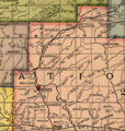
This 1905 map shows Recording District #24. Antlers was its judicial seat.

See also
 In Spanish: Antlers (Oklahoma) para niños
