
Archway, London facts for kids
Quick facts for kids Archway |
|
|---|---|
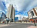
 Archway Navigator Square with Vantage Point, station, the Archway Tavern and Wenzel's bakery |
|

Archway
|
|
| OS grid reference | TQ285875 |
| • Charing Cross | 4 mi (6.4 km) N |
| London borough | |
| Ceremonial county | Greater London |
| Region | |
| Country | England |
| Sovereign state | United Kingdom |
| Post town | LONDON |
| Postcode district | N19 |
| Dialling code | 020 |
| Police | Metropolitan |
| Fire | London |
| Ambulance | London |
| EU Parliament | London |
| UK Parliament | |
| London Assembly |
|
Archway is a lively area in north London, England. It's part of the London Borough of Islington and is about 3.8 kilometers (2.4 miles) north of Charing Cross, a famous spot in central London. The area gets its name from a special landmark: the tall, single-arched Archway Bridge. This bridge crosses over a road that runs through a deep cut in the ground. Today, Archway has a busy town center with modern buildings like Vantage Point and the Archway tube station.
Contents
History of Archway
Where the Name Comes From

The name Archway comes from an old bridge called Hornsey Lane Bridge. This bridge connects Highgate to Crouch End by crossing over the Archway Road. The first bridge, built in 1813, was made of brick. It was replaced in 1900 by the current bridge, which is made of cast-iron. Old maps from 1893 simply called it "Highgate Archway." Some older people who grew up here still call the area "the Archway."
Many bus routes in London end at 'Archway'. The name became very popular after the local tube station, which was first called Highgate, changed its name several times. It became Highgate (Archway) in 1939, then Archway (Highgate) in 1941, and finally just Archway in 1947.
How Archway Grew
Archway Road is part of the A1, also known as the Great North Road. This was one of the first roads where people had to pay a fee, called a toll, to use it. From 1813 to 1864, there was a toll gate in the road's cutting. Travelers paid here for the next part of their journey. You can still see a plaque at 1 Pauntley Street that remembers this.
The road from Archway up to Highgate village, called Highgate Hill, was home to Europe's first motorized cable car. It ran from 1884 to 1909. The Archway tube station (which was first called Highgate) opened on June 22, 1907. It was the northern end of the Highgate branch of the Northern line on the London Underground.
Local Government
Archway is part of the Islington North Parliament constituency. This means it's part of the area that elects a Member of Parliament (MP) to the UK Parliament. Most of Archway is in the Junction ward, named after Junction Road. A smaller part is in the Hillrise ward. Each of these wards chooses three councillors to represent them on the Islington London Borough Council.
People of Archway
Archway is a diverse area with people from many different backgrounds. The local wards, Junction and Hillrise, show this mix. For example, many people identify as White British, but there are also significant numbers of people from other White backgrounds, as well as Black African, Black Caribbean, and Asian communities. Many different religions are practiced here, including Christianity, Islam, and Judaism. The Archway area has one of the highest percentages of Jewish people in Islington, especially in the Whitehall Park area. It also has a notable number of people of White Irish heritage.
Geography and Landmarks
.jpg)
The Whittington Hospital is a large hospital located in the west of Archway. The area also has several green spaces where people can relax, including Archway Park, Dartmouth Park, Hillside Park, and Navigator Square. Archway is part of the N19 postcode district in London.
Archway is next to Highgate and Crouch End to the north. Hornsey Lane forms the border between the London Borough of Islington and the London Borough of Haringey. To the west, you'll find Dartmouth Park, with Dartmouth Park Hill marking the boundary with the London Borough of Camden. South of Archway are the areas of Upper Holloway and Tufnell Park.
Shopping and Fun
The Archway market place and Vantage Point, which is the tallest building in Archway, are right next to the tube station.
A famous band called The Kinks took the photograph for the cover of their 1971 album Muswell Hillbillies at the Archway Tavern, a pub in the area.
Getting Around
Trains and Underground
The closest London Underground station is Archway tube station, which is on the Northern line. The nearest London Overground station is Upper Holloway.
Bus Routes
Many bus routes serve Archway, connecting it to different parts of London. These include routes 4, 17, 41, 43 (which runs 24 hours), 134 (also 24 hours), 143, 210, 263, 390 (24 hours), C11, and W5. There are also Night Bus routes N20, N41, and N271 for late-night travel.
Culture and Stories
Dick Whittington's Legend
A famous story is linked to Archway through the Whittington Hospital and a statue on an old street. The legend tells of Dick Whittington, who later became a medieval Mayor of London. The story says that when he was a young man, he was leaving the city feeling sad because he hadn't made his fortune. From this spot, about 4.5 miles from central London, he supposedly heard the Bow Bells (from a church called St Mary-le-Bow on Cheapside) ringing out, telling him to "turn again Whittington, thrice Lord Mayor of London."
A restored memorial stone from 1821, topped with a small statue of Whittington's Cat, is known as the Whittington Stone. It's next to a pub with the same name on Highgate Hill. This memorial marks the legendary spot where Dick Whittington heard the bells. Sir Richard Whittington, the real person, was known for building a maternity hospital and drains for the poor. He left his money to a charity that still helps people today. Pauntley Street in Archway is named after Pauntley village in Gloucestershire, which is traditionally believed to be Dick Whittington's birthplace.
Irish Community
Archway has been home to a large Irish community since the 1830s, even before the big migration during the Great Famine. Many Irish people worked as "navigators" building railways and roads in the area. After the Second World War, the Irish community grew even more as the new Whittington Hospital hired many nurses from Ireland.
Even though fewer people immigrate now, the Irish influence is still strong. You can see it in pubs like The Mother Red Cap, in local shops selling Irish newspapers, and in the name of the pedestrian area, Navigator Square. This square is named after those Irish navigators who helped build many of the roads in the area.
See Also
- Upper Holloway
- Highgate
Images for kids
-
Archway Navigator Square with Vantage Point, station, the Archway Tavern and Wenzel's bakery
-
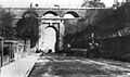
The original Archway Bridge designed by John Nash, opened in 1813 and demolished in 1900.
-
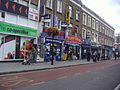
Shops in Junction Road, Archway
