Arthur County, Nebraska facts for kids
Quick facts for kids
Arthur County
|
|
|---|---|

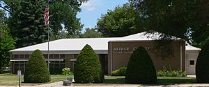
Arthur County Courthouse in Arthur
|
|

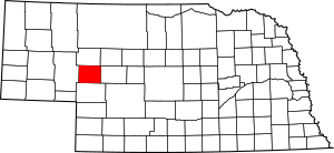
Location within the U.S. state of Nebraska
|
|
 Nebraska's location within the U.S. |
|
| Country | |
| State | |
| Founded | 1913 |
| Named for | Chester A. Arthur |
| Seat | Arthur |
| Largest Community | Arthur |
| Area | |
| • Total | 718 sq mi (1,860 km2) |
| • Land | 715 sq mi (1,850 km2) |
| • Water | 3.0 sq mi (8 km2) 0.4%% |
| Population
(2020)
|
|
| • Total | 430 |
| • Density | 0.6/sq mi (0.2/km2) |
| Time zone | UTC−7 (Mountain) |
| • Summer (DST) | UTC−6 (MDT) |
| Congressional district | 3rd |
Arthur County is a small county in the state of Nebraska, USA. In 2020, only 434 people lived there, making it one of the smallest counties in Nebraska and in the entire United States. Its main town and county seat is called Arthur.
When Nebraska started its license plate system in 1922, Arthur County was given the number 91. This was because it had the 91st highest number of cars registered in the state at that time.
Arthur County is home to the historic First Arthur County Courthouse and Jail. Many believe it is the smallest courthouse in the United States!
Contents
History of Arthur County
Arthur County was created in 1913. It was formed from the western part of McPherson County. People wanted to move the county seat of McPherson County to a more central place called Flats. However, the people in Tryon, the original county seat, did not want to lose it. So, they agreed to split the county in half.
The new half became Arthur County. Ranchers had started settling this area around 1884, looking for open land for their animals. A post office opened in Lena in 1894. Also, a new law called the Kinkaid Act in 1904 allowed people to claim larger pieces of land (640 acres instead of 160 acres). These things helped the new county get started quickly.
How Arthur County Got Its Name
The new county was named after President Chester A. Arthur. The village of Arthur was also named after him and became the county seat. In 1914, the main postal service moved from Lena to the village of Arthur.
The village of Arthur had public schools, a general store, a bank, churches, and a newspaper. All these services helped support the county's rural, ranching way of life.
Growth and Changes Over Time
In 1920, the census counted 1,412 people living in Arthur County. The county has always been mostly rural, focused on ranching. The village of Arthur got electricity in the 1920s. However, most of the county did not get electricity or phone service until 1950–1951.
Around that time, new highways also made travel easier. Nebraska Highway 61 runs north-south, and Nebraska Highway 92 runs east-west. Cars were the only way to get around, as Arthur County never had a railroad or canal. Farmers started irrigating the land around 1900, which continued through the first half of the 20th century.
The county's population was highest around 1930, with 1,344 people. But it dropped during the Great Depression. By 1950, the population was 803, and by 1980, it was down to 513.
Geography
Arthur County covers about 718 square miles. Most of this area, about 715 square miles, is land. Only about 3 square miles (0.4%) is water.
Main Roads
Neighboring Counties
- Grant County - to the north
- Hooker County - to the northeast
- McPherson County - to the east
- Keith County - to the south
- Garden County - to the west
Population Information
| Historical population | |||
|---|---|---|---|
| Census | Pop. | %± | |
| 1920 | 1,412 | — | |
| 1930 | 1,344 | −4.8% | |
| 1940 | 1,045 | −22.2% | |
| 1950 | 803 | −23.2% | |
| 1960 | 680 | −15.3% | |
| 1970 | 606 | −10.9% | |
| 1980 | 513 | −15.3% | |
| 1990 | 462 | −9.9% | |
| 2000 | 444 | −3.9% | |
| 2010 | 460 | 3.6% | |
| 2020 | 434 | −5.7% | |
| US Decennial Census 1790-1960 1900-1990 1990-2000 2010-2013 |
|||
In 2020, there were 430 people and 178 households in Arthur County. The county is very spread out, with less than one person per square mile. Most people living in the county are White (96.1%). A small number are Native American (0.9%) or Asian (0.2%). About 4.2% of the population is Hispanic or Latino.
In 2000, there were 444 people and 185 households. About 27.6% of households had children under 18. Most households (63.2%) were married couples living together. The average household had 2.4 people.
The median age in the county was 40 years old. This means half the people were younger than 40, and half were older. About 23.9% of the population was under 18.
Religion
More than half of the people in Arthur County are Baptists. This makes it the northernmost county in the United States where Baptists are the majority.
Politics
Arthur County has a strong history of voting for Republican presidential candidates since 1936. In every election since 1952, the Republican candidate has received over 60% of the votes. This shows that most people in Arthur County tend to support the Republican Party.
| Year | Republican | Democratic | Third party | |||
|---|---|---|---|---|---|---|
| No. | % | No. | % | No. | % | |
| 2024 | 264 | 93.29% | 17 | 6.01% | 2 | 0.71% |
| 2020 | 260 | 91.23% | 21 | 7.37% | 4 | 1.40% |
| 2016 | 244 | 89.38% | 17 | 6.23% | 12 | 4.40% |
| 2012 | 227 | 86.64% | 30 | 11.45% | 5 | 1.91% |
| 2008 | 217 | 82.51% | 39 | 14.83% | 7 | 2.66% |
| 2004 | 240 | 90.23% | 24 | 9.02% | 2 | 0.75% |
| 2000 | 235 | 86.40% | 26 | 9.56% | 11 | 4.04% |
| 1996 | 187 | 72.48% | 25 | 9.69% | 46 | 17.83% |
| 1992 | 148 | 56.06% | 18 | 6.82% | 98 | 37.12% |
| 1988 | 210 | 78.07% | 58 | 21.56% | 1 | 0.37% |
| 1984 | 248 | 88.26% | 33 | 11.74% | 0 | 0.00% |
| 1980 | 245 | 76.80% | 57 | 17.87% | 17 | 5.33% |
| 1976 | 193 | 73.66% | 64 | 24.43% | 5 | 1.91% |
| 1972 | 236 | 83.99% | 45 | 16.01% | 0 | 0.00% |
| 1968 | 218 | 77.86% | 47 | 16.79% | 15 | 5.36% |
| 1964 | 243 | 65.85% | 126 | 34.15% | 0 | 0.00% |
| 1960 | 283 | 80.63% | 68 | 19.37% | 0 | 0.00% |
| 1956 | 248 | 78.48% | 68 | 21.52% | 0 | 0.00% |
| 1952 | 307 | 83.20% | 62 | 16.80% | 0 | 0.00% |
| 1948 | 199 | 57.51% | 147 | 42.49% | 0 | 0.00% |
| 1944 | 268 | 63.66% | 153 | 36.34% | 0 | 0.00% |
| 1940 | 348 | 64.21% | 194 | 35.79% | 0 | 0.00% |
| 1936 | 312 | 56.73% | 235 | 42.73% | 3 | 0.55% |
| 1932 | 237 | 39.77% | 338 | 56.71% | 21 | 3.52% |
| 1928 | 402 | 69.43% | 169 | 29.19% | 8 | 1.38% |
| 1924 | 143 | 34.88% | 101 | 24.63% | 166 | 40.49% |
| 1920 | 167 | 57.00% | 94 | 32.08% | 32 | 10.92% |
| 1916 | 143 | 32.13% | 286 | 64.27% | 16 | 3.60% |
Communities
Village
- Arthur (county seat)
Unincorporated Communities
These are smaller places in the county that are not officially organized as villages or towns:
See also
 In Spanish: Condado de Arthur (Nebraska) para niños

