Ashton, Idaho facts for kids
Quick facts for kids
Ashton, Idaho
|
|
|---|---|

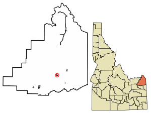
Location of Ashton in Fremont County, Idaho.
|
|
| Country | United States |
| State | Idaho |
| County | Fremont |
| Area | |
| • Total | 0.64 sq mi (1.65 km2) |
| • Land | 0.64 sq mi (1.65 km2) |
| • Water | 0.00 sq mi (0.00 km2) |
| Elevation | 5,259 ft (1,603 m) |
| Population
(2010)
|
|
| • Total | 1,127 |
| • Density | 1,645.77/sq mi (635.72/km2) |
| Time zone | UTC-7 (Mountain (MST)) |
| • Summer (DST) | UTC-6 (MDT) |
| ZIP codes |
83420, 83447
|
| Area code(s) | 208 |
| FIPS code | 16-03610 |
| GNIS feature ID | 2409741 |
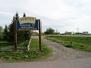
Ashton is a city in Fremont County, Idaho, United States. In 2010, about 1,127 people lived there. Ashton is famous for growing "seed potatoes." It is known as the world's largest area for growing these special potatoes.
Contents
History
Railroad
In 1900, the Union Pacific Railroad built a train line into the Upper Snake River Valley. This line went from Idaho Falls to St. Anthony, Idaho. People in the area wanted the railroad to help their towns grow.
Later, the Union Pacific Railroad planned another line. This one would go from St. Anthony to Yellowstone National Park. The railroad wanted to make it easier for tourists to visit Yellowstone's famous geysers. The new line would pass through a town called Marysville.
However, the people of Marysville did not want the railroad. So, the Union Pacific decided to build the line one mile west. They created a new town there in 1906. This new town was named Ashton, after William Ashton, a chief engineer for the railroad.
Ashton quickly grew, while Marysville became much smaller. The first trains arrived in Ashton in 1906. One of Ashton's founders, H. G. "Fess" Fuller, became the city's mayor. Another founder, Charles C. Moore, later became the Governor of Idaho.
The new railroad line, called the Yellowstone Branch, was special. It was built mostly for passengers, especially tourists going to Yellowstone. Beautiful stone train stations were built to impress visitors. During the summer, special trains like the Yellowstone Special ran to the park. In winter, Ashton became the end of the line because the tracks further north were not cleared of snow.
Development
Starting in 1910, Ashton became important for building the Jackson Lake Dam. This dam is in Grand Teton National Park. Materials and equipment for the dam were brought by train to Ashton. Then, they were carried by wagons from Ashton to the dam site. This route was called the Ashton-Moran Road.
The Union Pacific Railroad also built another line from Ashton to Driggs and Victor. This line was finished in 1912. Ashton built engine houses and other railroad buildings to serve these lines. These developments helped Ashton grow and become a very important town in Eastern Idaho.
American Dog Derby
Ashton gets a lot of snow in winter. Because of this, people needed a way to travel when roads were covered. They started using dogsleds. Many people in the area became skilled at driving dog teams, called "mushers."
The idea for a dog race came from Jay Ball, a local businessman. He read about dog races in Alaska and Canada. So, the first race was held on March 4, 1917. It was a 55-mile race from West Yellowstone to Ashton. A snowstorm made the race last two days, but it was still a success.
The next year, the race was held on a special course around Ashton. This made it easier for people to watch. The Union Pacific Railroad helped promote the races. Soon, thousands of people came to Ashton each February to see the mushers and their dogs.
By 1923, the American Dog Derby was famous around the world. Reporters and cameramen came from far away cities. Crowds grew to 10,000 people or more, even though Ashton had less than two thousand residents. Winning mushers became celebrities. One female musher, known as Whistling Lyd, even toured the United States and Canada. Ashton became known as "the best known American town in the world."
Seed Potatoes
Ashton was always a farming community. The soil is rich, and there is plenty of water. Farmers dug canals to bring water from nearby rivers. Some land, especially to the east, gets enough rain that crops can grow without extra water.
At first, farmers grew crops like grain. In 1920, they started trying to grow "seed potatoes." It turned out that Ashton was perfect for them! The short growing season keeps the potatoes small, which is good for seeds. Also, the long, cold winters help clean the soil.
A common problem for potatoes is "potato blight," a type of mold. Ashton's cold winters kill the mold spores in the soil. This means the soil is clean each spring, and the blight does not spread. Farmers realized this was a big advantage. They organized and hired inspectors to make sure their seed potatoes were healthy.
Because Ashton's seed potatoes were free of mold and disease, farmers could sell them for a higher price. The area quickly became the largest seed potato growing region in the world. It is still known for this today.
Geography and climate
Ashton is located about 5,259 feet above sea level. This is quite high up!
The city covers about 0.66 square miles of land. There is no water area within the city limits.
Ashton is close to many natural wonders. It is about 18 miles from Yellowstone National Park. It is also about 24 miles from Grand Teton National Park. You can even see the Grand Teton mountain clearly from Ashton, which is 39 miles away.
Ashton is surrounded by farms. But it is less than five miles from the Targhee National Forest. There are four great trout fishing rivers nearby: the Henrys Fork, Fall River, the Teton River, and Warm River. You can also visit three beautiful waterfalls: Upper Mesa Falls, Lower Mesa Falls, and Cave Falls.
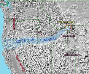
Moisture channel
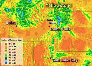
Ashton has a unique climate compared to other places in the western U.S. It gets about 20 inches of rain and snow each year. This is a lot for an area not in the mountains. For example, nearby St. Anthony gets only about 14 inches.
This extra moisture is because of the "Snake River Plain." This land feature creates a path for moisture from the Pacific Ocean to reach Ashton and Yellowstone. Ashton gets a lot of snow in winter. It also gets rain in May and June, like places in Montana and Wyoming. Summers in Ashton are usually drier.
Temperature and precipitation
| Climate data for Ashton, Idaho, 1991–2020 normals, extremes 1897–2023 | |||||||||||||
|---|---|---|---|---|---|---|---|---|---|---|---|---|---|
| Month | Jan | Feb | Mar | Apr | May | Jun | Jul | Aug | Sep | Oct | Nov | Dec | Year |
| Record high °F (°C) | 54 (12) |
61 (16) |
70 (21) |
88 (31) |
90 (32) |
98 (37) |
101 (38) |
99 (37) |
95 (35) |
85 (29) |
74 (23) |
60 (16) |
101 (38) |
| Mean maximum °F (°C) | 40.0 (4.4) |
44.2 (6.8) |
55.7 (13.2) |
71.6 (22.0) |
81.1 (27.3) |
86.0 (30.0) |
92.0 (33.3) |
91.7 (33.2) |
86.0 (30.0) |
74.7 (23.7) |
57.5 (14.2) |
42.5 (5.8) |
93.3 (34.1) |
| Mean daily maximum °F (°C) | 28.9 (−1.7) |
32.6 (0.3) |
42.3 (5.7) |
53.8 (12.1) |
65.3 (18.5) |
73.1 (22.8) |
82.6 (28.1) |
82.7 (28.2) |
72.5 (22.5) |
57.1 (13.9) |
40.1 (4.5) |
29.2 (−1.6) |
55.0 (12.8) |
| Daily mean °F (°C) | 21.1 (−6.1) |
24.7 (−4.1) |
33.4 (0.8) |
42.6 (5.9) |
52.5 (11.4) |
59.4 (15.2) |
66.7 (19.3) |
65.6 (18.7) |
57.1 (13.9) |
44.6 (7.0) |
31.4 (−0.3) |
21.9 (−5.6) |
43.4 (6.3) |
| Mean daily minimum °F (°C) | 13.4 (−10.3) |
16.8 (−8.4) |
24.5 (−4.2) |
31.4 (−0.3) |
39.7 (4.3) |
45.7 (7.6) |
50.9 (10.5) |
48.5 (9.2) |
41.8 (5.4) |
32.2 (0.1) |
22.7 (−5.2) |
14.6 (−9.7) |
31.9 (−0.1) |
| Mean minimum °F (°C) | −9.2 (−22.9) |
−4.0 (−20.0) |
4.6 (−15.2) |
16.1 (−8.8) |
25.8 (−3.4) |
32.8 (0.4) |
39.6 (4.2) |
36.8 (2.7) |
28.3 (−2.1) |
16.2 (−8.8) |
1.8 (−16.8) |
−8.8 (−22.7) |
−14.1 (−25.6) |
| Record low °F (°C) | −35 (−37) |
−37 (−38) |
−30 (−34) |
−3 (−19) |
6 (−14) |
18 (−8) |
24 (−4) |
20 (−7) |
10 (−12) |
−7 (−22) |
−18 (−28) |
−36 (−38) |
−37 (−38) |
| Average precipitation inches (mm) | 2.31 (59) |
1.53 (39) |
1.29 (33) |
1.70 (43) |
2.24 (57) |
2.15 (55) |
0.64 (16) |
0.85 (22) |
1.17 (30) |
1.63 (41) |
1.90 (48) |
2.26 (57) |
19.67 (500) |
| Average snowfall inches (cm) | 19.8 (50) |
10.7 (27) |
5.3 (13) |
2.0 (5.1) |
0.0 (0.0) |
0.0 (0.0) |
0.0 (0.0) |
0.0 (0.0) |
0.0 (0.0) |
1.6 (4.1) |
10.5 (27) |
20.2 (51) |
70.1 (177.2) |
| Average precipitation days (≥ 0.01 in) | 9.3 | 7.0 | 6.6 | 7.3 | 8.0 | 6.4 | 3.4 | 3.7 | 4.6 | 5.2 | 7.0 | 9.7 | 78.2 |
| Average snowy days (≥ 0.1 in) | 7.8 | 5.3 | 3.3 | 1.0 | 0.0 | 0.0 | 0.0 | 0.0 | 0.0 | 0.8 | 4.4 | 8.7 | 31.3 |
| Source 1: NOAA | |||||||||||||
| Source 2: National Weather Service | |||||||||||||
Demographics
2010 census
| Historical population | |||
|---|---|---|---|
| Census | Pop. | %± | |
| 1910 | 502 | — | |
| 1920 | 1,022 | 103.6% | |
| 1930 | 1,003 | −1.9% | |
| 1940 | 1,203 | 19.9% | |
| 1950 | 1,256 | 4.4% | |
| 1960 | 1,242 | −1.1% | |
| 1970 | 1,187 | −4.4% | |
| 1980 | 1,219 | 2.7% | |
| 1990 | 1,114 | −8.6% | |
| 2000 | 1,129 | 1.3% | |
| 2010 | 1,127 | −0.2% | |
| 2019 (est.) | 1,050 | −6.8% | |
| U.S. Decennial Census | |||
In 2010, Ashton had 1,127 people living there. There were 397 households, which are groups of people living together. About 39% of these households had children under 18.
The average age of people in Ashton was 33.4 years old. About 32% of the residents were under 18. Around 16% were 65 years old or older. The population was almost evenly split between males and females.
Education
Ashton has public schools for students. These include North Fremont High School and Middle School. There is also Ashton Elementary for younger students. These schools are part of the Fremont County Joint School District #215.
Notable residents
- Ryan Hamilton is a stand-up comedian. He was born in Ashton and often talks about the city in his comedy shows.
See also
 In Spanish: Ashton (Idaho) para niños
 | Delilah Pierce |
 | Gordon Parks |
 | Augusta Savage |
 | Charles Ethan Porter |


