
Aube facts for kids
Quick facts for kids
Aube
|
|||
|---|---|---|---|

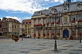
Prefecture building of the Aube department, in Troyes
|
|||
|
|||

Location of Aube in France
|
|||
| Country | France | ||
| Region | Grand Est | ||
| Département | 4 March 1790 | ||
| Prefecture | Troyes | ||
| Subprefectures | Bar-sur-Aube, Nogent-sur-Seine | ||
| Area | |||
| • Total | 6,004.2 km2 (2,318.2 sq mi) | ||
| Population
(2014)
|
|||
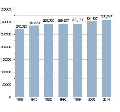
| • Total | 308,094 | ||
| • Density | 51.3131/km2 (132.9003/sq mi) | ||
| Time zone | UTC+1 (CET) | ||
| • Summer (DST) | UTC+2 (CEST) | ||
| ISO 3166 code | FR-10 | ||
| Arrondissements | 3 | ||
| Cantons | 17 | ||
| Communes | 431 | ||


Aube is a department in northeast France. It is named after the Aube river. The main city, or capital, of Aube is Troyes.
Contents
History of Aube
Aube was one of the first 83 departments created during the French Revolution. This happened on March 4, 1790. Troyes was chosen as its capital.
At first, Aube was divided into six areas called "districts." These were Nogent-sur-Seine, Arcis-sur-Aube, Bar-sur-Aube, Bar-sur-Seine, Ervy, and Troyes.
In 1800, France created new administrative areas called arrondissements. The six districts in Aube became five arrondissements: Arcis-sur-Aube, Bar-sur-Aube, Bar-sur-Seine, Nogent-sur-Seine, and Troyes.
After the famous Battle of Waterloo in 1815, the Russian army occupied the department. They stayed from June 1815 until November 1818.
Later, on September 10, 1926, the arrondissements of Arcis-sur-Aube and Bar-sur-Seine were removed.
Geography of Aube
The Aube department is located in the southwest part of the Grand Est region in France. It shares borders with five other departments from three different regions:
- In the Grand Est region:
* Marne (to the north) * Haute-Marne (to the east)
- In the Bourgogne-Franche-Comté region:
* Côte-d'Or (to the south) * Yonne (to the west)
- In the Île-de-France region:
* Seine-et-Marne (to the northwest)
 |
Seine-et-Marne | Marne | |
|
| Yonne | Haute-Marne | |||
| Côte-d'Or |
Aube covers an area of about 6,004 square kilometers (2,318 square miles). The highest point in the department is in the Bois du Mont forest. It is near the town of Champignol-lez-Mondeville in the southeast. This spot is about 370 to 375 meters (1,214 to 1,230 feet) high. The lowest point is about 60 meters (197 feet) high. It is in the town of La Motte-Tilly in the west.
The main rivers flowing through Aube are the Seine and the Aube. The Aube river flows into the Seine. Other rivers include the Amance and the Vanne.
Climate in Aube
The area around Troyes, which is about 105 meters (344 feet) above sea level, usually has mild temperatures. The climate here is known as a "Marine West Coast Climate." This means it has cool summers and mild winters.
On average, Troyes gets about 655.3 millimeters (25.8 inches) of rain each year. November is usually the wettest month, with about 99.1 millimeters (3.9 inches) of rain. July is the driest month, with only about 12.7 millimeters (0.5 inches) of rain.
The average temperature for the whole year in Troyes is 10.8°C (51.4°F). July is the warmest month, with an average temperature of 19.3°C (66.7°F). January is the coolest month, with an average temperature of 3.1°C (37.6°F).
| Climate data for Troyes, France | |||||||||||||
|---|---|---|---|---|---|---|---|---|---|---|---|---|---|
| Month | Jan | Feb | Mar | Apr | May | Jun | Jul | Aug | Sep | Oct | Nov | Dec | Year |
| Mean daily maximum °C (°F) | 6.2 (43.2) |
7.7 (45.9) |
11.9 (53.4) |
15.2 (59.4) |
19.5 (67.1) |
22.7 (72.9) |
25.7 (78.3) |
25.4 (77.7) |
21.2 (70.2) |
16.3 (61.3) |
10.1 (50.2) |
6.7 (44.1) |
15.7 (60.3) |
| Daily mean °C (°F) | 3.1 (37.6) |
3.7 (38.7) |
7 (45) |
9.5 (49.1) |
13.7 (56.7) |
16.7 (62.1) |
19.3 (66.7) |
19 (66) |
15.4 (59.7) |
11.6 (52.9) |
6.6 (43.9) |
3.8 (38.8) |
10.8 (51.4) |
| Mean daily minimum °C (°F) | −0.1 (31.8) |
−0.3 (31.5) |
2 (36) |
3.7 (38.7) |
7.8 (46.0) |
10.7 (51.3) |
12.8 (55.0) |
12.6 (54.7) |
9.6 (49.3) |
6.8 (44.2) |
3 (37) |
0.8 (33.4) |
5.8 (42.4) |
| Average rainfall mm (inches) | 65.4 (2.57) |
58.3 (2.30) |
54.4 (2.14) |
59 (2.3) |
40.9 (1.61) |
21.9 (0.86) |
11.7 (0.46) |
15.7 (0.62) |
50.6 (1.99) |
90.1 (3.55) |
98.3 (3.87) |
89 (3.5) |
655.3 (25.77) |
| Source: Weatherbase.com [1] | |||||||||||||
Government and Divisions
Aube is governed by the Departmental Council of Aube. This council is based in Troyes. The department is part of the larger Grand Est region.
Administrative Divisions
Aube is divided into:
- 3 arrondissements (which are like large districts)
- 17 cantons (smaller administrative areas)
- 431 communes (which are like towns or municipalities)
| INSEE code |
Arrondissement | Capital | Population (2014) |
Area (km²) |
Density (Inh./km²) |
Communes |
|---|---|---|---|---|---|---|
| 101 | Bar-sur-Aube | Bar-sur-Aube | 28,733 | 1,193.3 | 24.1 | 104 |
| 102 | Nogent-sur-Seine | Nogent-sur-Seine | 54,177 | 1,245.3 | 43.5 | 80 |
| 123 | Troyes | Troyes | 225,184 | 3,565.7 | 63.2 | 247 |
Here is a list of the 17 cantons in Aube. These were reorganized in March 2015:
- Aix-en-Othe (1001)
- Arcis-sur-Aube (1002)
- Bar-sur-Aube (1003)
- Bar-sur-Seine (1004)
- Brienne-le-Château (1005)
- Creney-près-Troyes (1006)
- Nogent-sur-Seine (1007)
- Les Riceys (1008)
- Romilly-sur-Seine (1009)
- Saint-André-les-Vergers (1010)
- Saint-Lyé (1011)
- Troyes-1 (1012)
- Troyes-2 (1013)
- Troyes-3 (1014)
- Troyes-4 (1015)
- Troyes-5 (1016)
- Vendeuvre-sur-Barse (1017)
People of Aube
People who live in Aube are called Aubois (for men) or Auboises (for women).
In 2014, Aube had a population of 308,094 people. This means there were about 51.3 people per square kilometer. The arrondissement of Troyes has the most people, with 225,184 residents.
Population Changes in Aube
Here are the communes (towns or cities) in the Aube department with the most people:
| City | Population (2014) |
Arrondissement |
|---|---|---|
| Troyes | 60,750 | Troyes |
| Romilly-sur-Seine | 14,303 | Nogent-sur-Seine |
| La Chapelle-Saint-Luc | 12,428 | Troyes |
| Saint-André-les-Vergers | 11,860 | Troyes |
| Sainte-Savine | 10,134 | Troyes |
| Saint-Julien-les-Villas | 6,891 | Troyes |
| Nogent-sur-Seine | 5,955 | Nogent-sur-Seine |
| Bar-sur-Aube | 5,014 | Bar-sur-Aube |
Places to See
-
Troyes, the capital city.
-
The town of Aix-en-Othe.
-
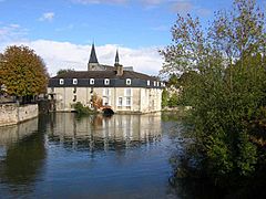
Clairvaux Abbey, a historic monastery.
-
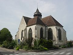
The town of Bar-sur-Aube.
-
The town of La Chapelle-Saint-Luc.


.jpg)
Related pages
Images for kids
-
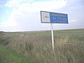
Entry to the Aube department from Route N77
-
The Seine at Bar-sur-Seine
-
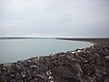
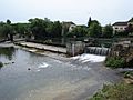
Temple Lake seen from the dam
-
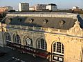
Troyes Station


See also
 In Spanish: Aube para niños
