Avondale, Arizona facts for kids
Quick facts for kids
Avondale, Arizona
|
||
|---|---|---|
|
City
|
||

Entrance sign
|
||
|
||

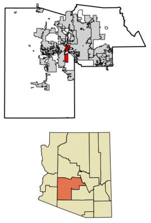
Location in Maricopa County, Arizona
|
||
| Country | United States | |
| State | Arizona | |
| County | Maricopa | |
| Area | ||
| • Total | 47.87 sq mi (123.99 km2) | |
| • Land | 47.62 sq mi (123.33 km2) | |
| • Water | 0.26 sq mi (0.67 km2) | |
| Elevation | 974 ft (297 m) | |
| Population
(2020)
|
||
| • Total | 89,334 | |
| • Density | 1,876.13/sq mi (724.38/km2) | |
| Time zone | UTC-7 (MST (no daylight saving time)) | |
| ZIP codes |
85323, 85392
|
|
| Area code(s) | 623 | |
| FIPS code | 04-04720 | |
| GNIS feature ID | 2409765 | |
Avondale is a city in Maricopa County, Arizona, United States. It is very close to Phoenix. In 2020, about 89,334 people lived there. This number has grown a lot since 2000.
Avondale became an official city in 1946. Before 1980, it was mostly a farming area. Farmers grew crops like alfalfa and cotton. Since then, Avondale has grown quickly. It is now a busy suburb where many people live and work in Phoenix.
Contents
History of Avondale
William "Billy" G. Moore came to Arizona in the late 1860s. In 1880, he settled near the Agua Fria River. He bought land and named his new settlement "Coldwater, Arizona." This name came from the river and a cool spring nearby.
Moore set up a stagecoach stop in the 1880s. It was called the Coldwater Stage Station. This was one of the first stops for travelers in the area. People traveling from Tucson to northern Arizona or California could get supplies there. A saloon and a general store were also built. This helped the settlement grow.
The post office opened in 1896 near the Avondale Ranch. From 1901 to 1905, William Moore was the Postmaster. Later, the post office and the town became known as Avondale. The name "Coldwater" was no longer used. In December 1946, Avondale officially became a city.
Over time, Avondale grew into a modern city. It is now close to the center of the Phoenix area. In the last ten years, the population grew by over 114%. This makes Avondale one of the fastest-growing cities in Maricopa County. The older part of town, along Western Avenue, still keeps its historic feel. It helps small, local businesses.
Geography and Climate
Avondale is located at 33°26′01″N 112°20′59″W / 33.43361°N 112.34972°W. To the west is Goodyear. To the north is Litchfield Park. To the east are Phoenix and Tolleson.
The city covers about 47.9 square miles. Only a small part of this area is water. The Gila River flows through the southern part of Avondale. The Agua Fria River joins it from the north.
Interstate 10 runs through the northern part of Avondale. This freeway goes east about 15 miles to Downtown Phoenix. It goes west about 134 miles to Blythe, California.
Avondale's Desert Climate
Avondale has a hot desert climate. This means it gets a lot of sunshine all year.
- Winters are sunny and mild. Nighttime temperatures are usually between 40°F (4°C) and 50°F (10°C). Daytime temperatures range from 60°F (16°C) to 75°F (24°C). The coldest temperature ever recorded was 16°F (−9°C).
- Summers are extremely hot. Daily high temperatures are often 100°F (38°C) or higher. This happens for most of June, July, and August. Sometimes, temperatures can even go above 115°F (46°C). Nighttime lows in summer are usually between 70°F (21°C) and 80°F (27°C). The hottest temperature ever recorded in Avondale was 125°F (52°C).
Snow is very rare in Avondale. It only happens once every few years. In the summer, from July to early September, the North American Monsoon can bring rain showers. Dust storms also happen sometimes, mostly in the summer.
| Climate data for Avondale, Arizona | |||||||||||||
|---|---|---|---|---|---|---|---|---|---|---|---|---|---|
| Month | Jan | Feb | Mar | Apr | May | Jun | Jul | Aug | Sep | Oct | Nov | Dec | Year |
| Record high °F (°C) | 89 (32) |
93 (34) |
100 (38) |
105 (41) |
115 (46) |
125 (52) |
125 (52) |
120 (49) |
116 (47) |
109 (43) |
98 (37) |
89 (32) |
125 (52) |
| Mean daily maximum °F (°C) | 65 (18) |
70 (21) |
76 (24) |
85 (29) |
94 (34) |
103 (39) |
105 (41) |
103 (39) |
98 (37) |
87 (31) |
74 (23) |
64 (18) |
85 (30) |
| Mean daily minimum °F (°C) | 42 (6) |
45 (7) |
50 (10) |
56 (13) |
64 (18) |
72 (22) |
79 (26) |
79 (26) |
72 (22) |
59 (15) |
48 (9) |
41 (5) |
59 (15) |
| Record low °F (°C) | 16 (−9) |
22 (−6) |
22 (−6) |
27 (−3) |
36 (2) |
49 (9) |
57 (14) |
50 (10) |
44 (7) |
31 (−1) |
22 (−6) |
20 (−7) |
16 (−9) |
| Average precipitation inches (mm) | 0.99 (25) |
1.28 (33) |
0.97 (25) |
0.37 (9.4) |
0.11 (2.8) |
0.04 (1.0) |
0.83 (21) |
1.23 (31) |
0.95 (24) |
0.49 (12) |
0.68 (17) |
0.99 (25) |
8.93 (227) |
| Source: The Weather Channel | |||||||||||||
Gila and Salt River Meridian Marker
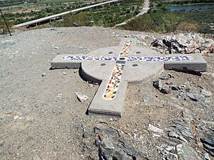
There is an important marker in Avondale called the Gila and Salt River Meridian. It is on Monument Hill. Since 1851, this spot has been used to measure land in Arizona. The U.S. government also used it to mark the border with Mexico after the Mexican–American War. This marker was added to the National Register of Historic Places in 2002. You can find Monument Hill at 115th Avenue and Baseline Road.
Population and People
| Historical population | |||
|---|---|---|---|
| Census | Pop. | %± | |
| 1920 | 517 | — | |
| 1930 | 1,770 | 242.4% | |
| 1950 | 2,505 | — | |
| 1960 | 6,151 | 145.5% | |
| 1970 | 6,626 | 7.7% | |
| 1980 | 8,168 | 23.3% | |
| 1990 | 16,169 | 98.0% | |
| 2000 | 35,883 | 121.9% | |
| 2010 | 76,238 | 112.5% | |
| 2020 | 89,334 | 17.2% | |
| 2024 (est.) | 94,870 | 24.4% | |
| U.S. Decennial Census World Population Review |
|||
Avondale first appeared in the U.S. Census in 1920. Back then, it was called the 45th Precinct of Maricopa County. In 1946, it became the town of Avondale. It has been counted in every census since 1950. In 1959, it became a city.
In 2020, Avondale had 89,334 people. About 55.6% of the people were of Hispanic or Latino background. About 25.9% were White (not Hispanic). About 9.3% were Black or African American. Other groups made up the rest of the population.
In 2000, the average household had 3.36 people. The average family had 3.66 people. About 47.9% of homes had children under 18 living there. The median age in the city was 29 years old. This means half the people were younger than 29, and half were older.
Economy and Jobs
Avondale has many different businesses that provide jobs. Here are some of the top employers in the city as of 2022:
| # | Employer | # of employees |
|---|---|---|
| 1 | Amazon | 1,030 |
| 2 | City of Avondale | 660 |
| 3 | Tolleson Union High School District | 560 |
| 4 | Fry’s Food Stores | 520 |
| 5 | Maricopa County Community Colleges | 460 |
| 6 | Avondale Elementary School District | 420 |
| 7 | Akos | 400 |
| 8 | Littleton Elementary School District | 390 |
| 9 | Walmart | 380 |
| 10 | Costco Wholesale | 370 |
Sports and Recreation
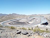
Avondale is home to Phoenix Raceway. This is a famous race track. Since 2020, Phoenix Raceway has hosted the yearly NASCAR championship race in November. It also holds other NASCAR races throughout the year.
The Avondale Parks and Recreation Department offers many sports. They have programs for both kids and adults.
City Parks
Avondale has several parks where you can play and relax:
- Alamar Park, 4155 S El Mirage Rd
- Las Ligas, 12421 W Lower Buckeye Road
- Festival Fields, 101 E. Lower Buckeye
- Donnie Hale Park, 10857 West Pima St.
- Friendship Park / Dog Park, 12325 West McDowell
- Mountain View, 201 E Mountain View Drive
- Sernas Plaza Park, 521 E Western Ave
- Fred Campbell Park, 101 E Lawrence Blvd
- Dennis DeConcini, 351 E Western Ave
- Dessie Lorenz Park, 202 E Main St
- Doc Rhodes Park, 104 W Western Ave
Education in Avondale
Avondale has many schools for students of all ages.
Public Schools
The city is served by several school districts:
- Littleton Elementary School District
- Avondale Elementary School District
- Agua Fria Union High School District
- Tolleson Union High School District
There are four public high schools within Avondale:
- Agua Fria High School
- La Joya Community High School
- Westview High School
- West Point High School
Charter and Private Schools
Avondale also has charter schools. These include Legacy Traditional School and Imagine Schools for younger students. For high school, there is Estrella High School and St. John Paul II Catholic High School.
Colleges and Universities
For higher education, Avondale has:
- Estrella Mountain Community College, which opened in 1992.
- A satellite building for Rio Salado College.
- Campuses for Universal Technical Institute and Empire Beauty Schools.
City Infrastructure
Transportation in Avondale
Avondale has public transportation options. Valley Metro Bus serves the city. The Avondale ZOOM is a local bus service that helps people get around Avondale. Other bus routes connect Avondale to nearby cities like Phoenix and Ajo.
Healthcare Services
Avondale has healthcare facilities to help its residents.
- Valleywise Health operates the Valleywise Community Health Center – Avondale. Their main hospital is in Phoenix.
- Phoenix Children's Hospital has satellite locations in Avondale. These include an Emergency Department and a Sports Medicine Physical Therapy center.
Notable People from Avondale
Many talented people have come from Avondale, including:
- Mitch Garcia, a professional soccer player.
- Shawn Gilbert, a professional baseball player.
- Everson Griffen, a defensive end for the Minnesota Vikings.
- Nick Harris, a punter for the NFL's Detroit Lions.
- Drisan James, a wide receiver for the CFL's Hamilton Tiger-Cats.
- Craig Mabbitt, a vocalist for the band Escape the Fate.
- Randall McDaniel, a former NFL offensive guard. He is in the Pro Football Hall of Fame.
- Clancy Pendergast, a defensive coordinator for the Kansas City Chiefs.
- Shelley Smith, a professional football player.
See also
 In Spanish: Avondale (Arizona) para niños
 | Tommie Smith |
 | Simone Manuel |
 | Shani Davis |
 | Simone Biles |
 | Alice Coachman |


