
Back River (Nunavut) facts for kids
Quick facts for kids Back River |
|
|---|---|
.jpg)
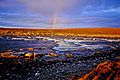
Rock garden on the Back River in July 2006
|
|


Back River mouth location in Canada
|
|
| Native name | Thlewechodyeth (Tłı̨chǫ) Haningayok (Inuktitut) |
| Other name(s) | Great Fish River |
| Country | Canada |
| Territories | Nunavut & Northwest Territories |
| Physical characteristics | |
| Main source | Unnamed lake North Slave Region, Northwest Territories 382 m (1,253 ft) 64°43′38″N 108°02′08″W / 64.72722°N 108.03556°W |
| River mouth | Chantrey Inlet, Arctic Ocean Kitikmeot Region, Nunavut 0 m (0 ft) 67°16′00″N 95°15′00″W / 67.26667°N 95.25000°W |
| Length | 974 km (605 mi) |
| Depth |
|
| Basin features | |
| Basin size | 106,500 km2 (41,100 sq mi) |
The Back River is a very long river in Canada. It is the 20th longest river in the country! It flows through the Northwest Territories and Nunavut.
This river starts in an unnamed lake in the Northwest Territories. It then travels over 974 kilometers (about 605 miles). Most of its journey is through the Kivalliq Region of Nunavut. Finally, it empties into the Arctic Ocean.
The local Tłı̨chǫ people call it Thlewechodyeth. The Inuktitut people call it Haningayok. It was also known as the Great Fish River.
Contents
Exploring the Back River's Path
The Back River begins in a lake that is 382 meters (about 1,253 feet) high. It flows west into Sussex Lake. Then it turns north towards Muskox Lake. Here, it crosses the border into Nunavut.
Many smaller rivers join the Back River along its way. These are called tributaries. The Icy River and Contwoyto River are some of the first to join. The river also passes through many rapids, like the Muskox Rapids.
As it continues, the Back River flows through a long lake called Lake Beechey. More rivers, like the Baillie River and Warren River, add to its waters. It also goes over more rapids, such as the Hawk Rapids.
The river forms part of the northern border of the Thelon Wildlife Sanctuary. This is a special protected area for animals. The Back River then reaches Pelly Lake. From there, it flows through a series of lakes, including Upper Garry Lake, Garry Lake, and Lower Garry Lake.
After these lakes, the river goes over several more rapids. These include the Rock Rapids, Sinclair Falls, and Escape Rapids. It also passes by Mount Meadowbank and McKay Peak. Finally, the Back River reaches Franklin Lake. It continues northeast and eventually flows into Cockburn Bay, which is part of Chantrey Inlet in the Arctic Ocean.
About the River's Area
The Back River's watershed covers a huge area. It is about 106,500 square kilometers (about 41,100 square miles). This is the total land area that drains into the river.
The river is known for its many rapids. There are 83 challenging rapids along its path! This makes it a difficult river to travel by canoe. Only very experienced canoeists can navigate it. Other large rivers in this part of Canada, like the Coppermine River and Kazan River, are also very challenging.
The entire Back River is located above the tree line. This means there are no tall trees growing along its banks. The landscape is mostly low-lying plants and rocks.
History of the Back River
The Back River area has been home to people for a very long time. The Haningayogmiut (or Hanningajurmiut) Copper Inuit people lived here. They were also known as the Ualininmiut. Other Inuit groups, like the Kaernermiut and Ahiagmiut, also visited this region.
The river was also near the northern edge of the lands of the Yellowknives and Chipewyan peoples.
The first European to explore the river was George Back in 1834. He was looking for another explorer, Captain John Ross. Back learned about the river from local guides. He called it "Thlew-ee-cho-dezeth," which meant "Great Fish River." Later, it became known as the "Back River" after him.
In 1845, Sir John Franklin led an expedition to map the Northwest Passage. His crew tried to reach the Back River after their ships got stuck in ice. Sadly, they did not survive. Years later, in 1855, James Anderson and James Stewart explored the river while searching for Franklin's lost expedition.
After a long break, the river was explored again in 1962 by two groups of canoeists. One group was from the United Kingdom and the other from the United States. Both groups filmed their trips. The British film, Beacon Six, was even shown on Canadian TV.
From 1963 to 1965, a researcher named Jean Briggs lived with the Utkusiksalinmiut Inuit people near the river. She studied their culture and helped create a dictionary for their language.
Wildlife and Nature
The area around the Back River is full of amazing wildlife. The river itself has many fish. On land, you can see caribou, muskoxen, and wolves. Sometimes, people also spot brown bears, wolverines, and Arctic hares. As the river gets closer to the Arctic Ocean, you might even see Polar bears!
A special area along the river, from Pelly Lake to Lower Garry Lake, is important for birds. It's a great place for Canada geese, lesser snow geese, and other waterfowl.
Like other parts of Northern Canada, the Back River region is very cold. Strong Arctic winds can blow like a gale, making the weather even more extreme.
Canoeing the Back River Today
Canoeing the Back River is a very long and difficult adventure. It takes over a month for strong and experienced canoeists. It is much harder than other rivers like the Kazan or Dubawnt.
Many rapids on the Back River end in "rock gardens." This means you often have to carry your canoe and gear around them. This is called portaging. The ground for portaging can be rocky and uneven.
After a set of rapids called the "Escape Rapids," the river becomes a bit easier. Many rapids can then be paddled through. However, it's still a challenging trip.
If you plan to canoe near the Arctic Ocean, it's a good idea to bring bear spray. This is for protection against polar bears. You also need to bring all your cooking fuel. Since there are no trees, you can't find wood for fires.
To start the trip, you can fly to the river's source by floatplane from Yellowknife. At the end, a bush plane can pick you up from a spot in the tundra. You need to make sure your canoe can fit on the plane!
Another option is to travel all the way to the end of the river. From there, a boat can take you to the Inuit community of Gjoa Haven. You can then fly back to Yellowknife from Gjoa Haven.
Because of the cold weather, it's best to be past Garry Lake by August 8th. After this date, the weather often gets worse. Strong winds can stop your trip at any time. The Arctic cold means that falling into the water can be very dangerous. It's highly recommended to use a canoe with a spray deck to keep water out.
Tributaries
- Hayes River (right)
- Mistake River (right)
- Hermann River (right)
- Meadowbank River (right)
- Bullen River (left)
- Consul River (right)
- McKinley River (right)
- Jervoise River (right)
- Warren River (left)
- Baillie River (right)
- Siorak River (left)
- Contwoyto River (left)
- Icy River (left)
Images for kids
-
Head of the Escape Rapids, August 2006
-
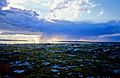
A view on Garry Lake


See also
 In Spanish: Río Back para niños
