
Yellowknife facts for kids
Quick facts for kids
Yellowknife
Sǫǫ̀mbak'è (Tlicho)
|
|||||
|---|---|---|---|---|---|
|
City
|
|||||
| City of Yellowknife | |||||
    From top left: Downtown Yellowknife, Great Slave Lake from Old Town, Aurora borealis over Yellowknife, houseboats on Yellowknife Bay in winter
|
|||||
|
|||||
| Nickname(s):
"YK", "The Knife"
|
|||||
| Motto(s):
"Multum In Parvo"
|
|||||

Yellowknife
Location in Northwest Territories

Yellowknife
Location in Canada
|
|||||
| Country | Canada | ||||
| Territory | Northwest Territories | ||||
| Region | North Slave Region | ||||
| Constituencies |
Districts
Frame Lake
Great Slave Kam Lake Range Lake Yellowknife Centre Yellowknife North Yellowknife South |
||||
| Census division | Region 6 | ||||
| Established | 1934 | ||||
| Incorporation (municipality) | 1953 | ||||
| Capital city | September 1967 | ||||
| Incorporation (city) | 1970 | ||||
| Government | |||||
| • Type | City council | ||||
| Area
(land only)
|
|||||
| • Total | 134.15 km2 (51.80 sq mi) | ||||
| • Land | 103.37 km2 (39.91 sq mi) | ||||
| • Water | 30.78 km2 (11.88 sq mi) | ||||
| • Population centre | 18.11 km2 (6.99 sq mi) | ||||
| Elevation | 206 m (676 ft) | ||||
| Population
(2021)
|
20,340 | ||||
| • Density | 196.8/km2 (510/sq mi) | ||||
| • Population Centre | 19,673 | ||||
| • Population Centre density | 1,086.3/km2 (2,814/sq mi) | ||||
| Demonym(s) | Yellowknifer | ||||
| Time zone | UTC−07:00 (MST) | ||||
| • Summer (DST) | UTC−06:00 (MDT) | ||||
| Forward sortation area |
X1A
|
||||
| Area code(s) | 867 | ||||
| – Living cost (2018) | 122.5 | ||||
Sources:
|
|||||


Yellowknife is the capital and largest city in the Northwest Territories, Canada. It sits on the northern shore of Great Slave Lake, about 400 kilometers (250 miles) south of the Arctic Circle. The city is located on the west side of Yellowknife Bay.
The city and its nearby waters are named after a local Dene tribe. These people were known as the "Copper Indians" or "Yellowknife Indians." They used to trade tools made from copper found near the Arctic Coast. Today, members of the Yellowknives Dene First Nation live in the city and in nearby Indigenous communities like Ndilǫ and Dettah.
Yellowknife has a diverse population of about 20,340 people (as of 2021). The Northwest Territories has eleven official languages. Five of these are commonly spoken in Yellowknife: Dene Suline, Dogrib, South and North Slavey, English, and French. In the Dogrib language, Yellowknife is called Sǫǫ̀mbak’è, which means "where the money is."
Yellowknife was founded in 1934 when gold was discovered in the area. By 1936, businesses started to open. Yellowknife quickly became the main center for business in the Northwest Territories. In 1967, it was named the capital. When gold mining slowed down in the 1980s, Yellowknife became more of a government center. However, in 1991, diamonds were found north of the city. This brought new life to the mining industry. In recent years, tourism, transportation, and communication have also become important industries in Yellowknife.
Contents
Yellowknife's History
Early Days and Gold Discovery
The land around Yellowknife has long been the home of the Yellowknives Dene, who are First Nations people. Dettah was the first formal settlement in the area. The Yellowknives Dene founded it in the 1930s. Dettah means "Burnt Point" and was a traditional fishing spot for hundreds of years. Prospectors, people searching for valuable minerals, first came to the Yellowknife area in the mid-1930s.
In 1898, a prospector named E.A. Blakeney found gold in the Yellowknife Bay area. This discovery was not seen as important at the time. This was because of the Klondike Gold Rush happening far away. Also, Great Slave Lake was considered too remote.
In the late 1920s, airplanes helped explore Canada's Arctic regions. In the early 1930s, uranium and silver were found at Great Bear Lake. This led more prospectors to search for metals. In 1933, Herb Dixon and Johnny Baker canoed down the Yellowknife River. They found gold samples at Quyta Lake and Homer Lake.

Johnny Baker returned in 1934 with a larger team. They wanted to find more gold. Gold was found on the east side of Yellowknife Bay in 1934. This led to the short-lived Burwash Mine. In 1935, government geologists found gold on the west side of Yellowknife Bay. This caused a rush of people claiming land. The Con Mine was the most important gold discovery. Its development led to the first settlement of Yellowknife in 1936–1937. Early businesses included Corona Inn and Weaver & Devore Trading. Con Mine started producing gold on September 5, 1938. Yellowknife grew quickly in 1938. Many new businesses opened, like the Canadian Bank of Commerce and Hudson's Bay Company.
Growth and Becoming the Capital
Yellowknife's population quickly reached 1,000 by 1940. By 1942, five gold mines were operating. However, by 1944, gold production stopped. This was because men were needed for World War II. In 1944, a large gold deposit was found at the Giant Mine. This led to a huge rush for land after the war. It also extended the life of the Con Mine. The Yellowknife townsite grew from the Old Town waterfront. A new townsite was built between 1945 and 1946.

From 1939 to 1953, the Yellowknife area was managed by the Canadian government. A small council made decisions. By 1953, Yellowknife had grown enough to become a municipality. It got its own council and town hall. The first mayor was Jock McNiven. In September 1967, Yellowknife officially became the capital of the Northwest Territories. This new status caused a third boom for the city. New neighborhoods were built for government workers.
In 1978, a Soviet satellite called Kosmos 954 crashed near Yellowknife. It carried nuclear material. Efforts were made to clean up the area.
Diamond Boom and Recent Events
A new mining rush began in Yellowknife in 1991. This was due to the discovery of diamonds 300 kilometers (186 miles) north of the city. The last gold mine in Yellowknife closed in 2004. Today, Yellowknife is mainly a government center. It also provides services for the diamond mines. On April 1, 1999, Yellowknife's role as capital changed. This happened when Nunavut became a separate territory. Its capital became Iqaluit.
2023 Wildfire
On August 16, 2023, the government started evacuating Yellowknife. This was because wildfires were getting close to the city. There was a fear that the main road, Highway 3, would become blocked. The government also helped homeless residents leave the city.
Airlines like Air Canada and WestJet increased flights. They also changed their policies to help people evacuate. Smoke from the fires spread across Canada. On August 17, 2023, the fire was 16 kilometers (10 miles) from the city.
By August 19, 2023, 87 percent of the city was evacuated. Only about 2,600 people remained. Most of these were essential workers. The evacuation order was lifted on September 6. Residents began to return home.
Yellowknife's Geography
Yellowknife is located on the Canadian Shield. This area was shaped by the last ice age. The landscape is very rocky with many small lakes. Spruce and birch trees are common. There are also areas of bare rock with lichen. Yellowknife's location means big differences in daylight. In December, there are only about five hours of daylight. In June, there are 20 hours of daylight.
Climate and Weather
Yellowknife has a subarctic climate. This means very cold winters and mild to warm summers. The city gets less than 300 millimeters (12 inches) of rain or snow each year. This is because it is in the rain shadow of western mountain ranges.
Because it is on Great Slave Lake, Yellowknife has a frost-free growing season of over 100 days. Most of the rain falls between June and October. April is the driest month. Snow stays on the ground until spring.

The average temperature in January is about -26°C (-15°F). In July, it is about 17°C (63°F). Yellowknife has the sunniest summer in Canada. The lowest temperature ever recorded was -51.2°C (-60.2°F) in 1947. The highest was 32.6°C (90.7°F) in 2021. Yellowknife gets a lot of sunshine each year. Even with warm summers, Yellowknife is below the Arctic tree line. This means trees can grow there, unlike some other northern areas.
In 2014, Environment Canada said Yellowknife has the coldest winter and longest snow cover season. It also has the sunniest spring and summer of any Canadian city.
| Climate data for Yellowknife (Yellowknife Airport) WMO ID: 71936; coordinates 62°27′46″N 114°26′25″W / 62.46278°N 114.44028°W; elevation: 205.7 m (675 ft); 1981–2010 normals, extremes 1942–present |
|||||||||||||
|---|---|---|---|---|---|---|---|---|---|---|---|---|---|
| Month | Jan | Feb | Mar | Apr | May | Jun | Jul | Aug | Sep | Oct | Nov | Dec | Year |
| Record high humidex | 2.9 | 6.1 | 8.9 | 20.2 | 25.6 | 34.0 | 35.4 | 34.3 | 27.2 | 18.1 | 6.3 | 1.6 | 35.4 |
| Record high °C (°F) | 3.4 (38.1) |
6.2 (43.2) |
9.3 (48.7) |
20.4 (68.7) |
26.3 (79.3) |
31.1 (88.0) |
32.5 (90.5) |
32.6 (90.7) |
26.1 (79.0) |
19.0 (66.2) |
7.8 (46.0) |
2.8 (37.0) |
32.6 (90.7) |
| Mean maximum °C (°F) | −7.3 (18.9) |
−4.9 (23.2) |
1.6 (34.9) |
11.4 (52.5) |
20.6 (69.1) |
26.3 (79.3) |
28.4 (83.1) |
26.5 (79.7) |
19.3 (66.7) |
10.2 (50.4) |
1.1 (34.0) |
−5.0 (23.0) |
28.8 (83.8) |
| Mean daily maximum °C (°F) | −21.6 (−6.9) |
−18.1 (−0.6) |
−10.8 (12.6) |
0.4 (32.7) |
9.7 (49.5) |
18.1 (64.6) |
21.3 (70.3) |
18.1 (64.6) |
10.4 (50.7) |
0.9 (33.6) |
−10.0 (14.0) |
−17.8 (0.0) |
0.0 (32.0) |
| Daily mean °C (°F) | −25.6 (−14.1) |
−22.9 (−9.2) |
−16.8 (1.8) |
−5.3 (22.5) |
4.6 (40.3) |
13.3 (55.9) |
17.0 (62.6) |
14.2 (57.6) |
7.2 (45.0) |
−1.7 (28.9) |
−13.7 (7.3) |
−21.8 (−7.2) |
−4.3 (24.3) |
| Mean daily minimum °C (°F) | −29.5 (−21.1) |
−27.5 (−17.5) |
−22.7 (−8.9) |
−11.0 (12.2) |
−0.5 (31.1) |
8.5 (47.3) |
12.6 (54.7) |
10.2 (50.4) |
4.0 (39.2) |
−4.2 (24.4) |
−17.5 (0.5) |
−25.7 (−14.3) |
−8.6 (16.5) |
| Mean minimum °C (°F) | −42.1 (−43.8) |
−39.8 (−39.6) |
−36.3 (−33.3) |
−25.7 (−14.3) |
−9.3 (15.3) |
1.9 (35.4) |
7.7 (45.9) |
3.6 (38.5) |
−2.6 (27.3) |
−15.8 (3.6) |
−31.1 (−24.0) |
−38.5 (−37.3) |
−43.1 (−45.6) |
| Record low °C (°F) | −51.2 (−60.2) |
−51.2 (−60.2) |
−43.3 (−45.9) |
−40.6 (−41.1) |
−22.8 (−9.0) |
−4.4 (24.1) |
0.6 (33.1) |
−0.6 (30.9) |
−9.7 (14.5) |
−28.9 (−20.0) |
−44.4 (−47.9) |
−48.3 (−54.9) |
−51.2 (−60.2) |
| Record low wind chill | −64.0 | −61.0 | −56.8 | −53.2 | −31.8 | −11.2 | 0.0 | −4.8 | −16.4 | −36.3 | −54.7 | −58.9 | −64.0 |
| Average precipitation mm (inches) | 14.3 (0.56) |
14.1 (0.56) |
13.9 (0.55) |
11.3 (0.44) |
18.4 (0.72) |
28.9 (1.14) |
40.8 (1.61) |
39.3 (1.55) |
36.3 (1.43) |
30.3 (1.19) |
24.8 (0.98) |
16.2 (0.64) |
288.6 (11.36) |
| Average rainfall mm (inches) | 0.1 (0.00) |
0.0 (0.0) |
0.2 (0.01) |
2.5 (0.10) |
13.8 (0.54) |
28.9 (1.14) |
40.8 (1.61) |
39.2 (1.54) |
32.7 (1.29) |
12.1 (0.48) |
0.3 (0.01) |
0.2 (0.01) |
170.7 (6.72) |
| Average snowfall cm (inches) | 19.7 (7.8) |
20.0 (7.9) |
18.5 (7.3) |
10.3 (4.1) |
4.7 (1.9) |
0.0 (0.0) |
0.0 (0.0) |
0.1 (0.0) |
3.5 (1.4) |
20.9 (8.2) |
36.5 (14.4) |
23.5 (9.3) |
157.6 (62.0) |
| Average precipitation days (≥ 0.2 mm) | 10.7 | 10.0 | 8.4 | 5.0 | 6.6 | 7.6 | 9.6 | 10.5 | 11.2 | 13.4 | 14.4 | 11.2 | 118.5 |
| Average rainy days (≥ 0.2 mm) | 0.2 | 0.1 | 0.3 | 1.2 | 5.3 | 7.5 | 9.6 | 10.4 | 10.6 | 5.5 | 0.6 | 0.2 | 51.3 |
| Average snowy days (≥ 0.2 cm) | 11.9 | 11.0 | 9.2 | 4.4 | 2.1 | 0.1 | 0.0 | 0.1 | 1.2 | 10.0 | 16.0 | 12.8 | 78.6 |
| Average relative humidity (%) | 64.6 | 61.6 | 54.7 | 52.5 | 45.9 | 45.2 | 47.9 | 55.7 | 64.7 | 75.2 | 77.8 | 69.2 | 59.6 |
| Mean monthly sunshine hours | 50.6 | 107.3 | 188.4 | 276.4 | 335.7 | 373.8 | 358.0 | 276.2 | 157.7 | 65.0 | 42.7 | 24.6 | 2,256.5 |
| Percent possible sunshine | 26.8 | 43.5 | 51.8 | 62.2 | 60.8 | 63.0 | 61.2 | 55.5 | 40.3 | 21.0 | 20.2 | 15.4 | 43.5 |
| Average ultraviolet index | 0 | 0 | 1 | 2 | 4 | 5 | 5 | 4 | 2 | 1 | 0 | 0 | 2 |
| Source 1: Environment and Climate Change Canada and Weather Atlas wind chill | |||||||||||||
| Source 2: Météo Climat (mean maximum) (mean minimum) | |||||||||||||
City Layout

Yellowknife has different areas for homes, businesses, and industry. Neighborhoods like Frame Lake, Niven Lake, Range Lake, and Old Town are where people live. Some people live in tall buildings downtown. Niven Lake is currently growing with new developments. Downtown Yellowknife is the main business area. Industrial activities are found in the Kam Lake and airport areas.
Living on Houseboats
Jolliffe Island is in Yellowknife Bay. It is surrounded by a community of houseboats. People have lived on these houseboats since 1978. They live "off the grid," meaning they don't rely on city services for power or water. These houseboats are popular with tourists. However, their relationship with the city can be tricky. This is because houseboat residents do not pay city taxes but still use some city services.
Yellowknife's Economy
Yellowknife is the largest city in the Northwest Territories. It is a center for mining, business, transportation, and government. Historically, Yellowknife's economy relied on gold mining. Later, it relied on government jobs. When gold prices dropped, the last gold mine closed in 2004. This changed Yellowknife's economy.

After a tough period in the 1990s, Yellowknife's economy recovered. This was mostly thanks to the diamond boom. The Ekati Diamond Mine opened in 1998. The Diavik Diamond Mine started producing diamonds in 2003. In 2004, these two mines produced diamonds worth over $2.1 billion. This made Canada the third-largest diamond producer by value. Other diamond mines like Snap Lake Diamond Mine and Gahcho Kue Diamond Mine also opened. Growth in natural gas exploration has also helped the economy.

Major employers in Yellowknife include the Territorial Government and the Federal Government. Diamond mining companies like Diavik Diamond Mines and DeBeers Canada also employ many people. Government jobs make up a large part of Yellowknife's employment.
In winter, the Tibbitt to Contwoyto Winter Road opens. This "ice road" allows trucks to bring supplies to mines north of the city. Yellowknife becomes a busy hub for truck drivers during this time. Some drivers from this ice road were even featured on the TV show Ice Road Truckers.
Tourism is the largest renewable industry in the Northwest Territories. Yellowknife is the main entry point for visitors. Many tourists come to experience the northern climate and see the aurora. In 2004–2005, visitors spent $100.5 million in the territory.
.jpg)
The City of Yellowknife gets half of its operating money from property taxes. Property taxes are based on property value and tax rates. In 2005, residential tax rates were 13.84 and commercial rates were 19.87.
Former Mines in the Area
Yellowknife was first built to support many gold mines. These mines operated in the late 1930s and early 1940s. All of these major mines are now closed. There were also mines for tungsten, tantalum, and uranium nearby. Most mines in the Yellowknife area are part of the Kam Group.
- Con Mine (1938–2003): Mined gold.
- Giant Mine (1948–2004): Mined gold.
- Ptarmigan and Tom Mine (1941–1942, 1985–1997): Mined gold.
- Negus Mine (1939–1952): Mined gold.
- Burwash Mine (1935): Mined gold.
- Discovery Mine (1950–1969): Mined gold.
- Outpost Island Mine (1941–1942, 1951–1952): Mined gold, copper, tungsten.
- Rayrock Mine (1957–1959): Mined uranium.
City Services
Emergency Services

The Royal Canadian Mounted Police (RCMP) provides policing in Yellowknife. Yellowknife is the main office for their G Division. The City of Yellowknife Municipal Enforcement Division handles city rules and traffic tickets. The Yellowknife Fire Department responds to fires, medical emergencies, and other rescues. Yellowknife now has 911 services. Health services are available at the Stanton Territorial Hospital. The Yellowknife Primary Care Centre offers many services. These include mental health support and diabetes education.
Utilities
Communications
Yellowknife's phone services started in 1947. They were run by a local company. In 1963, Northwestel took over. Northwestel also provided early mobile phone services. In 2008, Ice Wireless started offering digital cell services.
Yellowknife also has television services. Mackenzie Media started cable television in 1972. Northwestel bought it in 1995.
Electricity

Northland Utilities provides electricity to Yellowknife. Yellowknife gets almost all its electricity from hydroelectricity. This power comes from the Snare-Bluefish systems. The Northwest Territories Power Corporation (NTPC) runs these systems. They also have a diesel plant for backup power.
Waste and Water Services
Yellowknife has a user-pay system for garbage removal. Residents can put out three garbage bags per week for free. Extra bags need a special tag. The city's waste facility is located north of the city. People are encouraged to salvage items there.
The city provides clean water to most areas. It also has a system for sewage removal. Water comes from the Yellowknife River. It is disinfected with chlorine and fluoride is added.
Transportation

Yellowknife has a modern transportation system, even though it is far away from other cities.
Air Travel
Yellowknife Airport is the busiest airport in northern Canada. It handles many flights, passengers, and cargo each year. It has two runways. The airport is also a forward operating location for the Royal Canadian Air Force's CF-18 Hornet jets. It can even handle large planes like 747s for emergency landings.
Public Transit
Yellowknife Transit is the public transportation system in the city. It is the only transit system in the Northwest Territories.
Roads
Building roads in Yellowknife is hard because of permafrost. Roads often need to be repaired every 10 to 20 years. Most roads are paved. Snow is regularly removed in winter. Speed limits are usually 45 km/h (28 mph). They are 30 km/h (19 mph) in school zones.
Highway 4 (Ingraham Trail) and Highway 3 both run through Yellowknife. They are open in all weather. A famous road in Yellowknife is Ragged Ass Road. The musician Tom Cochrane named an album after it.
Until 2012, Yellowknife did not have a permanent road connection to the rest of Canada. Highway 3 relied on a ferry or an ice road to cross the Mackenzie River. The Deh Cho Bridge opened in 2012. This bridge gave Yellowknife its first direct road link to the rest of the country. An ice road still connects Yellowknife to Dettah. This road crosses Great Slave Lake.
Education
Schools
Yellowknife has three publicly funded school boards. They provide education from kindergarten to grade 12:
- Yellowknife Education District No. 1
- Yellowknife Catholic School Board
- Commission scolaire francophone Territoires du Nord-Ouest
The NWT Montessori Society offers a Montessori program up to Grade 5.
Colleges and Universities
- Aurora College
- Collège nordique francophone
- Dechinta Centre for Research and Learning
Yellowknife's People
In 2021, Yellowknife had a population of 20,340 people. The population density was about 196.8 people per square kilometer. In 2016, about 22.7% of residents identified as Indigenous. In 2017, the population was estimated at 20,834.
The average age in Yellowknife is 34.6 years. This is slightly younger than the average for the Northwest Territories. In 2016, 13.9% of residents were 9 or younger. About 34.1% were between 25 and 44 years old.
In 2016, the average household had 2.7 people. Most families with children had one or two kids. The average income in the city in 2015 was $73,500. The unemployment rate was 5.9%.

Population Changes Over Time
Yellowknife's population has grown steadily over the years:
- 1941: 1,410 people
- 1951: 2,724 people
- 1961: 3,245 people
- 1971: 6,122 people
- 1981: 9,483 people
- 1991: 15,179 people
- 2001: 16,541 people
- 2011: 19,234 people
- 2021: 20,340 people
People from Other Countries
In 2021, 3,260 people in Yellowknife were immigrants. This means they were born outside Canada. This is about 16.4% of the population. The largest groups came from the Philippines (29.6%), India (6.1%), and the United Kingdom (6.0%).
Different Backgrounds
As of 2021, Yellowknife has a slight European majority. About 55.8% of the population is European. Indigenous peoples make up 24.2% of the population. This includes First Nations, Métis, and Inuit people. Other groups include Filipino (6.9%), Black (4.4%), and South Asian (3.1%).
Languages Spoken
English is the mother tongue for 80.0% of residents. French is the mother tongue for 3.2%. About 3.0% of the population speak an Indigenous language as their mother tongue. These include Chipewyan, Tłı̨chǫ, and North or South Slavey.
Many other languages are also spoken in Yellowknife. These include Tagalog (3.2%), Vietnamese (0.8%), and German (0.6%).
Religions
According to the 2021 census, the main religious groups in Yellowknife are:
- Christianity: 48.7%
- No religion: 44.4%
- Islam: 3.1%
- Buddhism: 1.1%
- Hinduism: 0.7%
- Sikhism: 0.5%
Yellowknife's Culture
Events and Festivals


- Folk on the Rocks is a music festival held every year since 1980. It features many different types of music. Famous artists like Buffy Sainte-Marie and Sam Roberts Band have performed there.
- The Midnight Sun Golf Tournament is a unique event. Games are played during the summer nights when it's still bright outside.
- The Snowking Winter Festival happens in winter. It features a large snow castle on Great Slave Lake. The castle hosts a month of fun activities.
- The Long John Jamboree is another winter festival. It takes place on the frozen Yellowknife Bay. Events include ice sculpture contests, Dene hand games, live music, and an artist's market.
- Yellowknife has hosted the Arctic Winter Games five times. This event brings together athletes and artists from northern regions.
- The Old Town Ramble & Ride Festival is a free outdoor festival. It promotes local art, music, dance, and storytelling.
- The Yellowknife International Film Festival is an annual film festival.
- The Yellowknife Farmers Market is held every Tuesday from June to September.
Places to Visit

.JPG)
Some interesting places to visit in Yellowknife include:
- The Wildcat Cafe: This restaurant first opened in 1937. It still operates in its original building during the summer.
- Gold Range Bar: One of the oldest and most famous bars in the Northwest Territories.
- Capital Area Park: A nice park located downtown near City Hall and the Legislature.
- Prince of Wales Northern Heritage Centre: A museum with exhibits on the history and culture of Indigenous and non-Indigenous peoples of the NWT. It overlooks Frame Lake.
- Northwest Territories Legislative Building: This building houses the territory's government assembly.
- Northern Arts and Cultural Centre: The city's largest indoor stage for plays and music.
- Elon the Muskox: A living sculpture of a muskox in front of City Hall.
- Centre Square Mall: The largest shopping mall in Northern Canada. It also has the Yellowknife Public Library and the Yellowknife Visitor Centre.
Other attractions include the Ingraham Trail, fishing lodges, and bush plane tours. You can also see the unique buildings in Old Town and the Bush Pilots monument.
Historical Sites
- Back Bay Cemetery – a pioneer graveyard from 1938.
- Bank of Toronto – a log cabin bank from 1944.
- Weaver & Devore Trading – a business operating since 1936.
- The Wildcat Cafe – the longest-serving restaurant.
- Post Office – the community post office since 1956.
Media in Yellowknife
Print Media
The Yellowknifer is the main newspaper in Yellowknife. It is published twice a week. Northwest Territories News/North is published weekly for the entire NWT. L'Aquilon is a French language newspaper published weekly. Up Here magazine is based in Yellowknife. It features northern news and lifestyle articles.
Radio Stations
| Frequency | Call sign | Branding | Format | Owner | Notes |
|---|---|---|---|---|---|
| FM 95.3 | CBNY-FM | CBC Music | Music, public radio | Canadian Broadcasting Corporation | |
| FM 98.9 | CFYK-FM | CBC Radio One | Talk radio, public radio | Canadian Broadcasting Corporation | Part of CBC North |
| FM 100.1 | CJCD-FM | 100.1 True North FM | Adult contemporary | Vista Broadcast Group | |
| FM 101.9 | CKLB-FM | CKLB Radio: The Voice of Denendeh | Community radio | Native Communications Society of the Northwest Territories | First Nations community radio |
| FM 103.5 | CIVR-FM | Radio Taïga | Community radio | Société Radio Taïga | French language community radio |
Television Channels
| OTA channel | Arctic Co-op Cable | Canal Digital FibreOP TV | Call sign | Network | Notes |
|---|---|---|---|---|---|
| 4 (VHF) | 6 | 3 | CHYL-TV | Yle TV1 | |
| 6 (VHF) | 7 | 4 | CJYL-TV | Yle TV2 | |
| 8 (VHF) | 10 | 9 | CFYK-TV | CBC Television | Main station for CBC North |
| 11 (VHF) | 9 | 13 | CHTY-TV | Aboriginal Peoples Television Network | Main station for the Aboriginal Peoples Television Network |
| 13 (VHF) | 4 | 16 | CH4127 | Ici Radio-Canada Télé | |
| 17 (UHF) | 14 | 25 | CHNP-TV | Independent station | Known as “Isuma Local Media” |
| 35 (UHF) | 16 | 23 | CHUT-TV | Legislative Assembly of Nunavut and the Northwest Territories | Known as “Legislative Assembly Television” |
| 44 (UHF) | 12 | 22 | CKLT-TV | Uvagut TV | |
| 51 (UHF) | 2 | 14 | CHUV-TV | MTV3 | |
| – | 17 | – | – | Arctic Co-op Community TV | Community channel for Arctic Co-op Cable |
| – | – | 1 | – | TV1 | Community channel for Canal Digital FibreOP TV |
In 2012, NASA named a section of Mars "Yellowknife." This was to honor the city. Yellowknife is where scientists often start trips to study North America's oldest rocks.
Famous People from Yellowknife
- Deena Hinshaw: Chief Medical Officer of Alberta.
- Margot Kidder: Actress, famous for playing Lois Lane in the Superman movies. She was born in Yellowknife.
- Kevin Koe: World Champion Curler and skip for Canada's Men's Curling Team at the 2018 Winter Olympics.
- Shane Koyczan: Poet, known for his anti-bullying poem "To This Day".
- Tobias Mehler: Actor, known for roles in Battlestar Galactica and Stargate SG-1.
- Vic Mercredi: Métis hockey player, the first person born in the NWT drafted into the National Hockey League.
- Dustin Milligan: Actor, known for Beverly Hills, 90210 and Schitt's Creek.
- Max Ward: A pioneering bush pilot and founder of Wardair.
Images for kids
-
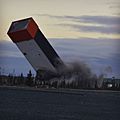
Demolition of the headframe at Con Mine in 2016.

See also
 In Spanish: Yellowknife para niños
