
Basin (geology) facts for kids

A basin in geology is a large area of land that is lower than the land around it. Think of it like a giant bowl or a dip in the ground. These areas are often found below sea level.
Geological basins are one of the main places inland where sediment (like sand, mud, and tiny bits of rock) collects. The types of rocks and sediments found in a basin can tell scientists a lot about what the climate was like in that area millions of years ago. Geologists, who study rocks, and paleontologists, who study ancient life, find basins very interesting.
Contents
How Basins Form
Basins can form in a few different ways:
- Stretching of the Earth's Crust: Sometimes, the Earth's crust (the outer layer of our planet) gets stretched out. When this happens, parts of the crust can sink down, creating a basin. Examples include the North Sea and Death Valley.
- Plates Pushing Together: When two large pieces of the Earth's crust, called continental plates, push against each other, one plate might slide over the other. This can cause the lower plate to bend and flex, forming a deep dip called a foreland basin. The Po River basin in Italy, next to the Alps, is an example.
- Rifting: A rift is like a giant crack in the Earth's crust where the land is pulling apart. As the land separates, it can create a long, deep valley that becomes a basin, like the Dead Sea rift.
Death Valley: A Stretched Basin


About 16 million years ago, a huge part of the North American Plate started to get stretched and pulled apart. This stretching continues even today! It has created a large area where the Earth's crust is relatively thin. This region is known as the Basin and Range Province.
When the Earth's crust is pulled apart, the rocks deep down can stretch like soft clay. But rocks closer to the surface tend to break along cracks called faults. These breaks cause blocks of land to drop down, forming the low-lying basins we call grabens. Death Valley is a famous example of this process.
What Collects in Basins
Because basins are low-lying, they are perfect places for sediment to collect. Rivers often flow down into basins from nearby mountains, bringing along mud, sand, and other materials. Sometimes, floods or lakes can form in basins, and if there's no outlet to the sea, the water might just evaporate. When the water evaporates, it leaves behind more sediment. Over long periods, these layers of sediment build up, forming different types of rock layers, or strata. These layers give us clues about the ancient climate of the area.
You might hear other words used to describe a basin, especially when talking about water. These include drainage basin, catchment area, river basin, or watershed.
How Water Leaves Basins
Some basins, like the Great Basin in the western United States, do not have rivers that flow out to the sea. In these endorheic basins, the water either sinks into underground aquifers (underground water storage) or evaporates, often forming salt lakes.
However, most basins are drainage basins where rivers carry water from the basin all the way to the sea. Many of these rivers, like the Amazon and Mississippi river systems, wind their way through the land and carry huge amounts of sediment to the ocean. The layers of rock that form in these basins are quite different from those found in inland lake basins.
Images for kids
-
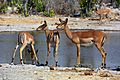
A watering hole is a natural depression where water collects and animals come to drink
-
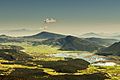
Karst closed depression with permanent lake Stymfalia, Peloponnese, Greece. Seasonal abundant precipitation drained by 3 sinkholes


See also
 In Spanish: Depresión (geografía) para niños
