Bay Mills Township, Michigan facts for kids
Quick facts for kids
Bay Mills Township, Michigan
|
|
|---|---|

|
|

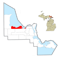
Location within Chippewa County
|
|
| Country | United States |
| State | Michigan |
| County | Chippewa |
| Area | |
| • Total | 98.0 sq mi (253.7 km2) |
| • Land | 64.7 sq mi (167.6 km2) |
| • Water | 33.2 sq mi (86.0 km2) |
| Elevation | 627 ft (191 m) |
| Population
(2020)
|
|
| • Total | 1,567 |
| • Density | 15.997/sq mi (6.177/km2) |
| Time zone | UTC-5 (Eastern (EST)) |
| • Summer (DST) | UTC-4 (EDT) |
| ZIP code(s) | |
| Area code(s) | 906 |
| FIPS code | 26-06070 |
| GNIS feature ID | 1625894 |
| Website | https://baymillstownship.org/ |
Bay Mills Township is a community in Chippewa County, Michigan, in the United States. It is a type of local government area called a civil township. According to the 2020 census, 1,567 people lived in the township.
Contents
What Communities Are in Bay Mills Township?
Bay Mills Township is home to two main communities:
- Bay Mills is a small community located on Bay Mills Point. This point separates two bays, Back Bay and Waiska Bay. These bays are at the start of the St. Marys River, which flows into the larger Whitefish Bay of Lake Superior. Bay Mills was started in 1875 as a lumber mill. It is close to the Bay Mills Indian Community. Mail service for Bay Mills uses the ZIP code 49715 from nearby Brimley.
- Mission is another small community. It is located in the northeastern part of the township. Mission is found near Bay Mills and Bay Mills Point.
Where is Bay Mills Township Located?
Bay Mills Township is in the northern part of Chippewa County. It is on the Upper Peninsula of Michigan. To the north, it touches Whitefish Bay, which is part of Lake Superior. The St. Marys River forms its northeastern border.
The community of Bay Mills is about 20 miles (32 km) west of Sault Ste. Marie by road. Most of the township is inside the Hiawatha National Forest.
The township covers a total area of about 98 square miles (253.7 square kilometers). Of this, about 64.7 square miles (167.6 square kilometers) is land. The remaining 33.2 square miles (86.0 square kilometers), or about 34%, is water.
Who Lives in Bay Mills Township?
Based on the census from 2000, there were 1,214 people living in Bay Mills Township. These people lived in 485 households. About 345 of these households were families.
- Households:
* About 36.5% of households had children under 18 living there. * About 51.5% were married couples living together. * About 14.8% were female-led households without a husband present. * About 23.7% of all households were made up of people living alone. * About 7.0% had someone 65 years or older living alone. * The average household had 2.50 people. * The average family had 2.92 people.
- Population Age:
* About 28.3% of the population was under 18 years old. * About 10.0% were between 18 and 24 years old. * About 29.0% were between 25 and 44 years old. * About 19.9% were between 45 and 64 years old. * About 12.9% were 65 years or older. * The average age in the township was 33 years.
- Income:
* The average income for a household was $35,875. * The average income for a family was $39,286. * The average income per person in the township was $18,285. * About 11.8% of the population lived below the poverty line. This included 18.6% of those under 18 and 1.4% of those 65 or older.
What is the History of Bay Mills Township?
In 2021, on Easter Sunday, the Kateri Tekakwitha church in Bay Mills caught fire. A picture of the saint survived the fire. In May of the same year, another fire broke out at the same church. This second fire completely destroyed the building.
See also
 In Spanish: Municipio de Bay Mills para niños
 | Janet Taylor Pickett |
 | Synthia Saint James |
 | Howardena Pindell |
 | Faith Ringgold |


