
Bayt Jibrin facts for kids
Quick facts for kids
Bayt Jibrin
بيت جبرين
Beit Jibrin
originally Bayt Gibril -Gabriel- |
|
|---|---|

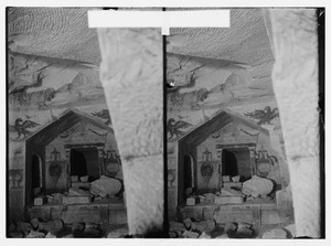
Historic Bayt Jibrin mansion
|
|
.jpg) 1870s map 1870s map.jpg) 1940s map 1940s map.jpg) modern map modern map.jpg) 1940s with modern overlay map 1940s with modern overlay mapA series of historical maps of the area around Bayt Jibrin (click the buttons)
|
|

Bayt Jibrin
Location in Mandatory Palestine
|
|
| Geopolitical entity | Mandatory Palestine |
| Subdistrict | Hebron |
| Date of depopulation | 29 October 1948 |
| Area | |
| • Total | 56,185 dunams (56.2 km2 or 21.7 sq mi) |
| Population
(1945)
|
|
| • Total | 2,430 |
| Cause(s) of depopulation | Military assault by Yishuv forces |
| Current Localities | Beit Guvrin (kibbutz) |
Bayt Jibrin or Beit Jibrin (Arabic: بيت جبرين) was a historic town in the Middle East. It was located about 21 kilometers (13 miles) northwest of the city of Hebron. The town was once home to many people but became empty in 1948.
Bayt Jibrin covered a large area of land, about 56,185 dunams (which is about 56.1 square kilometers or 21.7 square miles). Most of this land was used for farming. Only a small part, about 0.28 square kilometers (0.11 square miles), had buildings on it.
This area has a very long history. Around 200-400 CE, the town was known as Eleutheropolis, which means "Free City" in Greek. It was an important center during the Roman Empire. Later, under the British Mandate, Bayt Jibrin was again a key district center for nearby villages.
During the 1948 Arab–Israeli War, the town was captured by Jewish forces. This caused its Arab residents to leave. Today, many of these families and their children live in refugee camps in the West Bank. The kibbutz (a type of community settlement) called Beit Guvrin was started nearby in 1949. The ancient sites of Bayt Jibrin are now part of an Israeli national park and a UNESCO World Heritage Site.
Contents
What's in a Name?
.jpg)
The town's name changed many times over the centuries. Its old name, Beth Gabra, came from the Aramaic language. It meant "house of the strong man" or "house of the mighty one." An ancient geographer named Ptolemy called it Baitogabra.
Around 200 CE, the Roman Emperor Septimius Severus gave the town a new Greek name: Eleutheropolis. This means "City of the Free." He also gave its people special rights as Roman citizens, freeing them from some taxes.
Later, in the 4th century, the town was known as Beit Gubrin or Guvrin in the Talmud (a collection of Jewish teachings). When the Crusaders arrived, they called it Bethgibelin. Another name used in medieval times was Beit Jibril, meaning "house of Gabriel." In Arabic, Bayt Jibrin means "house of the powerful," which is similar to its original Aramaic meaning.
A Look Back in Time
Ancient Maresha and Early Settlements
The oldest remains found here are from the Iron Age, a time when people used iron tools. A town called Maresha grew up on a nearby hill. The Hebrew Bible mentions Maresha several times. Local stories say that the Arab village of Bayt Jibrin was first settled by Canaanites.
After the Kingdom of Judah was destroyed around 586 BCE, Maresha became part of the Edomite kingdom. Later, a group of people from Sidon settled there. Maresha was a base for attacks during the Maccabean Revolt. It was eventually conquered and destroyed by the Hasmonean king, John Hyrcanus I. After this, the area became Jewish. Around 40 BCE, Maresha was completely ruined and never rebuilt. Bayt Jibrin then became the main center of the region.
Roman and Byzantine Periods
During the First Jewish–Roman War in 68 CE, many people in the area were killed or enslaved. However, Bayt Jibrin continued to be a city where Jewish people lived until the Bar Kokhba revolt (132-135 CE).

Emperor Septimius Severus made Eleutheropolis a major city around 200 CE. He gave its citizens special tax breaks. The city grew very large, even bigger than Jerusalem at that time. The Romans built many public buildings, military bases, aqueducts (water channels), and a large amphitheater (a round outdoor theater).
Eleutheropolis was a very important city. Seven main roads met there. A map from the 6th century CE, called the Madaba Map, shows Eleutheropolis as a walled city with towers and a main street.
Christianity spread to the city early on. Its first bishop (a church leader) was named Justus. In 325 CE, another bishop from Eleutheropolis, Macrinus, attended an important church meeting. A famous Christian scholar, Epiphanius of Salamis, was born near Eleutheropolis.
The Talmud mentions Beit Guvrin in the 3rd and 4th centuries, showing that Jewish communities were still active. The city was known for its rich, fertile land. Water was brought to the city through a long aqueduct. Eleutheropolis controlled a large area with over 100 villages.
Early Islamic Period
Around 630 CE, the Muslims conquered the area. They called the town Bayt Jibrin. An early Muslim historian, al-Baladhuri, said it was one of ten towns captured by the Muslim army. In 638 CE, fifty Byzantine soldiers were killed in Bayt Jibrin because they refused to stop being Christians.
Later, in 715 CE, a Muslim prince named Sulayman ibn Abd al-Malik was in Bayt Jibrin when he heard he would become the new leader (caliph). However, the town was destroyed in 796 CE during a civil war between Arab tribes.

Crusader and Mamluk Eras
In 1099, Crusaders from Europe invaded Palestine. In 1135, their king built a castle in Bayt Jibrin to protect important roads. He then gave the castle to the Knights Hospitallers, a group of knight-monks. They called their new settlement "Bethgibelin." Christian settlers were encouraged to live there.
In 1187, the Muslim army led by Saladin captured Bethgibelin and ordered the castle to be torn down. The Crusaders briefly regained control but lost it again in 1244. By 1283, the Mamluks from Egypt took over. Under Mamluk rule, Bayt Jibrin became a busy postal station and was part of the Hebron region.
Ottoman Rule and the 'Azza Family
The Ottomans conquered Palestine in 1516. Bayt Jibrin became part of the Hebron district. The Ottomans often let local leaders stay in power as long as they paid taxes. In 1552, the destroyed Crusader castle was partly rebuilt to protect the road between Gaza and Jerusalem. In 1596, about 50 Muslim families lived in Bayt Jibrin.
In the 1800s, the 'Azza family ruled the Bayt Jibrin area. They had moved to Palestine from Egypt. They joined a revolt against Ottoman rule when the Ottomans tried to collect more taxes. The 'Azza family often fought with other local groups. In 1846, the leader of Bayt Jibrin, Muslih al-'Azza, was exiled but later allowed to return.

In 1855, the Ottoman governor tried to stop the rebellions. He visited Bayt Jibrin to collect taxes and get loyalty promises from local leaders. Early visitors were impressed by the 'Azza family's leader and his "castle," which was still part of the old Crusader fortress.
However, Bayt Jibrin's importance began to fade in the 19th century. Raids by Bedouin tribes, local wars, and diseases caused the town to decline. By 1896, the population was about 1,278 people.
British Mandate Era
After the British Army took control of Palestine in 1917-1918, Bayt Jibrin became an important town in the Hebron District again. The population was entirely Muslim. The town had two schools, a medical clinic, and a police station. People grew grain and fruit, and a weekly market brought visitors from nearby towns.
In 1920-1921, a bad outbreak of malaria hit the town. Many villagers died, and crops could not be harvested. The British authorities started programs to seal wells and give out medicine to fight the disease.
In 1922, a census showed Bayt Jibrin had 1,420 Muslim residents. By 1931, this number grew to 1,804 people living in 369 houses. In 1938, a British archaeologist named J. L. Starkey sadly died near Bayt Jibrin. By 1945, the population had increased to 2,430 Muslim inhabitants. Most of the land was owned by Arabs and used for farming.
The 1948 War
Under the 1947 UN Partition Plan, Bayt Jibrin was meant to be part of an Arab state. However, during the 1948 Arab–Israeli War, the Egyptian Army took positions in Bayt Jibrin. Thousands of people from other areas also fled to Bayt Jibrin.
In October 1948, the Israeli Army (IDF) launched a military operation. They used aircraft, artillery, and tanks. On October 15-16, the IDF bombed and attacked several towns, including Bayt Jibrin. These attacks caused many residents to flee the town in a panic.
A United Nations ceasefire began on October 23. However, an Israeli raid on a nearby police fort on October 24 caused even more villagers to leave Bayt Jibrin. Israeli troops then occupied Bayt Jibrin and its police fort on October 27.
In 1949, the kibbutz of Beit Guvrin was founded on the former town's lands. Today, the ancient sites of Bayt Jibrin are part of a large Israeli national park.
Where Was Bayt Jibrin?
Bayt Jibrin was located in an area of plains and gentle hills called the Shfela. This area is between the coastal plain to the west and the Hebron Hills to the east. The town was about 21 kilometers (13 miles) northwest of Hebron. It was about 275 meters (902 feet) above sea level.
Historically, Bayt Jibrin was on the main road that connected Cairo to Hebron, passing through Gaza. In 1945, almost all of Bayt Jibrin's land was owned by Arabs. Most of it was used for growing crops like cereals, olives, and other irrigated plants.
The Bayt Jibrin region is famous for its many caves. These caves are both natural and man-made. People dug them in the soft chalk over centuries to use as quarries, burial sites, animal shelters, workshops, and even places to raise doves. There are an estimated 800 such caves, many connected by underground tunnels. Eighty of these, known as the Bell Caves, are now part of the Beit Guvrin National Park.
Exploring the Past: Archaeology
Today, you can visit many of the excavated areas of Maresha and Beit Guvrin as part of the Beit Guvrin-Maresha National Park. You can even participate in excavations of the ancient cave systems.
In 1838, an American scholar named Edward Robinson visited Bayt Jibrin. He was the first to identify it as the ancient city of Eleutheropolis.
The remains of the city of Maresha were first dug up between 1898 and 1900. These excavations revealed a well-planned and fortified city from the Hellenistic period (when Greek culture was strong). Later excavations, from 1989 to 2008, focused on the lower city of Maresha and its underground complexes.
Archaeologists also found a large amphitheater built by the Romans. They also uncovered the biggest Roman bath in Israel and the Palestinian territories. Many ancient olive presses, columbaria (places for doves), and water cisterns (underground water tanks) can still be seen. Less than 10% of the caves on Tel Maresha have been explored.
There are also ruins of three churches from the Byzantine era (the Eastern Roman Empire) in Bayt Jibrin. One church had beautiful mosaics showing the four seasons. Another church, dedicated to Saint Anne, was rebuilt by the Crusaders in the 12th century. Some believe Bayt Jibrin is the birthplace of Saint Anne, the mother of the Virgin Mary.
Archaeological digs in the wider area have found even older artifacts. About 12 kilometers (7.5 miles) northeast of Bayt Jibrin, archaeologists found items from a village believed to be 6,500 years old. This dates back to the end of the Stone Age or the beginning of the Copper-and-Stone Age. The finds include pottery, stone tools, and animal bones. This shows that people lived here very early, likely because of the good farming land and many springs.
Who Lived Here?
During the Roman period, Bayt Jibrin had a mix of people: Jews, Christians, and pagans (people who believed in many gods). As Muslim rule grew, Islam became the main religion. By the 20th century, the entire population was Muslim.
In 1596, about 275 people lived in Bayt Jibrin. By the late 1800s, the population grew to about 900, and then to 1,278 in 1896. In 1912, it was around 1,000, and by 1922, it reached 1,420. The population continued to grow, reaching 1,804 in 1931 and 2,430 in 1945. By 1948, the estimated population was 2,819.
Today, many people who are descendants of the Bayt Jibrin residents live in refugee camps in the southern West Bank.
Culture and Traditions
Beautiful Embroidery
Bayt Jibrin, along with Hebron and nearby villages, was known for its beautiful Palestinian embroidery. This embroidery was often seen on traditional clothing.
For example, a woman's wedding dress from Bayt Jibrin, made around 1900, is now in a museum. It's made of indigo linen with long, pointed sleeves. The chest part has detailed embroidery with traditional patterns like "the bakers wife" and "cypress." The side panels also have cross-stitch embroidery.
Another item is a large veil called a shambar, worn at weddings and festivals in the late 19th century. It was made of black silk with a heavy red silk fringe. Women wore it on their wedding day so the embroidery would show when they covered their face. A headdress called an iraqiyeh was also worn by married women. It was embroidered and decorated with old coins. These elaborate headdresses were often passed down through families.
Holy Sites

In Islamic tradition, Bayt Jibrin is believed to be the burial place of Tamim al-Dari. He was a companion of the prophet Muhammad and was known for his strong faith. He briefly served as the Governor of Jerusalem in the 7th century. His family was given control over the Hebron Hills, including Bayt Jibrin. They were also in charge of the Cave of the Patriarchs in Hebron.
Tamim al-Dari's shrine (called a Maqam) is the most respected holy site in Bayt Jibrin. It is located northwest of the town. Even today, it is a place where local Muslims go on pilgrimage. Other Islamic holy sites in the village include shrines for a local male religious leader (shaykh) named Mahmud and a female religious figure (shaykha) named Ameina.
See also
- Beit Guvrin-Maresha National Park
- Ibelin, a Crusader castle
- Justus of Eleutheropolis
- Kibbutz Beit Guvrin
- Depopulated Palestinian locations in Israel
- List of villages depopulated during the Arab-Israeli conflict
- Maresha
- National Parks of Israel
- Peter of Eleutheropolis
- Zebennus
Images for kids
-
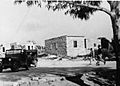
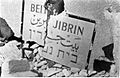
Bayt Jibrin after occupation by Harel Brigade, 1948
-
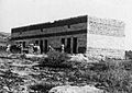
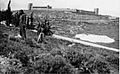
Building on outskirts of Bayt Jibrin, 1948
-
Beit Jibrin police station. 1948
-
Beit Guvrin Police station. 1948
-
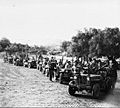
Members of the 89th Battalion outside Beit Gurvin, during Operation Yoav, October 1948


