
Bear Mountain (North Cascades) facts for kids
Quick facts for kids Bear Mountain |
|
|---|---|

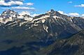
Bear Mountain (right) seen from Copper Ridge with its parent, Mt. Redoubt to left
|
|
| Highest point | |
| Elevation | 7,931 ft (2,417 m) |
| Prominence | 1,388 ft (423 m) |
| Isolation | 2.36 mi (3.80 km) |
| Parent peak | Mount Redoubt |
| Naming | |
| Native name | [Klahaihu] Error: {{native name}}: unrecognized language tag: Halkomelem (help) (language?) |
| Geography | |

Bear Mountain
Location in Washington (state)

Bear Mountain
Location in the United States
|
|
| Parent range | Cascade Range |
| Topo map | USGS Mount Redoubt |
| Geology | |
| Age of rock | 26 to 29 million years |
| Type of rock | Skagit gneiss and granodiorite |
| Volcanic belt | Pemberton Volcanic Belt |
| Climbing | |
| First ascent | 1939 Calder Bressler and William Thompson |
| Easiest route | Northwest Ridge Class 3-4 |
Bear Mountain is a tall mountain peak in the North Cascades area of Washington state. It stands about 7,931 feet (2,417 meters) high. This mountain is found inside North Cascades National Park.
Bear Mountain is quite remote, meaning it's far from towns and roads. Its closest higher neighbor is Mount Redoubt, which is about 2.36 miles (3.8 kilometers) away. Water flowing from Bear Mountain goes into Bear Creek and Indian Creek. These creeks then join the Chilliwack River. Getting to Bear Mountain can be tricky and often takes a few days of hiking.
Contents
Mountain Climate
Bear Mountain has a special kind of weather called a marine west coast climate. This means it gets a lot of moisture from the Pacific Ocean. Most weather systems start over the Pacific and move towards the Cascade Mountains.
Weather Patterns
As these weather systems reach the North Cascades, the tall peaks force the air upwards. This causes the moisture in the air to fall as rain or snow. Because of this, the western side of the North Cascades gets a lot of rain and snow, especially in winter.
During winter, it's often cloudy. But in summer, high-pressure systems over the Pacific Ocean bring clear skies. The snow here tends to be wet and heavy. This can create a high risk of avalanches, which are large slides of snow down a mountain.
How Mountains Formed
The North Cascades region has very rugged land. You can see sharp peaks, long ridges, and deep valleys carved by glaciers. These amazing shapes were created by geological events that happened millions of years ago.

Geological History
The Cascade Mountains began forming millions of years ago, during the late Eocene Epoch. This was when the North American Plate slowly moved over the Pacific Plate. This movement caused many volcanic eruptions.
Also, small pieces of the Earth's outer layers, called terranes, came together to form the North Cascades about 50 million years ago.
Ice Age Impact
During the Pleistocene period, which was over two million years ago, huge sheets of ice called glaciers moved across the land. These glaciers repeatedly advanced and then melted back. As they moved, they carved and shaped the landscape.
The U-shaped valleys you see in the mountains are a result of these glaciers. The lifting of the land (called uplift) and cracks in the Earth's crust (called faulting), along with the glaciers, have created the tall peaks and deep valleys of the North Cascades.
Images for kids
-
Bear Mountain (right) seen from Copper Ridge with its parent, Mt. Redoubt to left
