
Bear Rocks Preserve facts for kids
Quick facts for kids Bear Rocks Preserve |
|
|---|---|
|
IUCN Category V (Protected Landscape/Seascape)
|
|

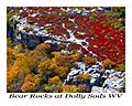
View from Bear Rocks
|
|

Bear Rocks Preserve
Location in West Virginia
|
|
| Location | Grant County & Tucker County, West Virginia, United States |
| Area | 477 acres (193 ha) |
| Elevation | 3,999 ft (1,219 m) |
| Website | Bear Rocks Preserve |
Bear Rocks are famous rock formations in West Virginia. They are a well-known symbol of the state's wild beauty. Many people love to photograph these unique rocks. They are part of a high-up area called a heathland. This land has many wind-carved sandstone rocks.
Bear Rocks is home to over a dozen rare plants and animals. It sits on top of the Allegheny Front. From here, you can see amazing views over the South Branch Potomac River. On a clear day, you might even see Shenandoah National Park in Virginia! The Bear Rocks Preserve is a 477-acre (1.93 km2) piece of land. It is owned and protected by The Nature Conservancy.
Contents
Where Are Bear Rocks Located?
Bear Rocks are a group of rock formations. They are found on the Allegheny Front. This is a steep slope that drops about two thousand feet. It also forms the Eastern Continental Divide. This means water on one side flows to the Atlantic Ocean. Water on the other side flows to the Gulf of Mexico.
Looking east, you can see the South Branch of the Potomac River. This river flows into the Atlantic Ocean through the Chesapeake Bay. On a clear day, you can see 35-mile (56 km) away. You might spot seven mountain ridges in Virginia. The highest peaks in Shenandoah National Park are also visible.
To the west, water flows into the Dolly Sods. This water eventually reaches the Gulf of Mexico. It travels through several rivers. These include the Dry Fork, Black Fork, Cheat, Monongahela, Ohio, and Mississippi River. Farther north along the ridge, you can find two more rock groups. They are called Stack Rocks and Haystack Rocks.
What is the Climate Like?
Bear Rocks has a cool climate. It looks a bit like an alpine area. You can also find northern wildlife here. Strong winds often blow clouds from the west. As these clouds rise over the Allegheny Front, they cool down. This causes a lot of mist and rain. The area gets over 60 inches (1,500 mm) of rain each year.
In the winter, there is a lot of snow. In 2003, 290 inches (7.4 m) of snow fell! Usually, about 160 inches (4.1 m) is more common. The strong winds, chilling frost, and heavy ice shape the trees. Along the ridge, you can see stunted red spruce trees. Their branches point to the east. This is because of the constant, strong winds.
Amazing Plants and Animals
Just below the ridge, you'll find a moist forest. It has red spruce and hemlock trees. The forest floor is covered with ferns. You can also see thickets of mountain laurel and rhododendron.
But on the wide ridge top, the weather is much harsher. Here, the lush plants give way to small, scattered trees. There are open heathlands and tundra plants. These plants have been here since the ice ages.
Many animals found here are usually seen in the North. These include snowshoe hares and saw-whet owls. You might also spot boreal red-backed voles and fishers. Bear Rocks is a great place to watch raptors and warblers. They pass through during their autumn migration. It's also a popular spot for picking berries in midsummer.
The area around Bear Rocks has special subalpine heathlands. These are mostly covered by shrubs. You'll find blueberries, huckleberries, mountain laurel, and azalea. Rhododendron bushes are also common. There are small groups of stunted red spruce trees. These trees are shaped by the ice and wind. You can also see rock outcrops, grassy meadows, and cranberry bogs.
Some areas are called "huckleberry plains" or "roaring plains". Here, the heathlands open up to natural grassy areas. These areas of mountain oat grass existed long before logging and fires in the late 1800s.
Unique Geology
You will see large, striking white sandstone and quartz rocks. They are found all over the Bear Rocks Preserve. Wind and rain have carved bowl-shaped holes in many of these rocks. These holes often fill with water or ice and algae.
Besides the carved boulders, there are "rock streams." These formed during past ice ages. Freezing and thawing cycles broke and moved rocks. This created rock streams up to 50 feet (15 m) wide. Some are hundreds of feet long. Other rock patterns, like polygons and circles, can also be seen.
Visiting Bear Rocks
There are informal trails that cross the Bear Rocks Preserve. You can find a larger system of trails on the nearby national forest lands. This includes the Dolly Sods Wilderness.
The natural heathlands and open grassy areas of Bear Rocks were first noted in 1746. This was by a survey team that included Peter Jefferson. He was the father of Thomas Jefferson.
Images for kids
-
Aerial Photo of Bear Rocks at Dolly Sods, WV by Greg Cromer - www.americafromthesky.com

