
Beatty, Nevada facts for kids
Quick facts for kids
Beatty
|
|
|---|---|
 |
|
| Nickname(s):
Gateway to Death Valley
|
|

Location of Beatty, Nevada
|
|
| Country | |
| State | |
| County | |
| Founded | 1905 |
| Named for | "Old Man" Montillus (Montillion) Murray Beatty |
| Area | |
| • Total | 17.70 sq mi (45.85 km2) |
| • Land | 17.68 sq mi (45.80 km2) |
| • Water | 0.02 sq mi (0.06 km2) |
| Elevation | 3,307 ft (1,008 m) |
| Population
(2020)
|
|
| • Total | 880 |
| • Density | 49.77/sq mi (19.22/km2) |
| Time zone | UTC−8 (PST) |
| • Summer (DST) | UTC−7 (PDT) |
| ZIP code |
89003
|
| Area code(s) | 775 |
| FIPS code | 32-05100 |
| GNIS feature ID | 0845356 |
| Website | Beatty, Nevada |
| Official name: Beatty (Center of the Gold Railroads--"Chicago of the West") | |
| Reference #: | 173 |
Beatty (pronounced BAYT-ee) is a small town in Nye County, Nevada, United States. It's not officially a city, but an "unincorporated town." This means it's a community that doesn't have its own local government, but is part of the larger county.
Beatty is located along the Amargosa River. U.S. Route 95 goes right through the town. It's about 90 miles (140 km) north of Tonopah and 120 miles (190 km) southeast of Las Vegas. State Route 374 connects Beatty to Death Valley National Park, which is only about 8 miles (13 km) to the west.
Before European settlers arrived, the Western Shoshone people lived in this area. Beatty was founded in 1905 and was named after Montillus "Old Man" Beatty, who had a ranch nearby. The town became important because of the railroads and gold mining. Today, Beatty is known as the "Gateway to Death Valley" and is a popular stop for tourists visiting the national park. It also has a museum and is close to the ghost town of Rhyolite.
Contents
History of Beatty
Before settlers from other countries came in the 1800s, the Beatty area was home to groups of Western Shoshone people. They hunted animals and gathered wild plants. Sadly, diseases brought by newcomers greatly reduced their population. By the mid-1800s, their traditional way of life was changing. Some Shoshone families continued to live near Beatty, while others moved to special areas called reservations.
Beatty is named after Montillus "Old Man" Beatty. He was a veteran from the Civil War and a miner. He bought a ranch near the future town and became its first postmaster in 1905. The town started to be planned in 1904 or 1905. This happened after Ernest Alexander "Bob" Montgomery, who owned a mine nearby, decided to build a hotel in Beatty. He was interested in the area because of a gold rush that began in 1904.

In its first year, wagons pulled by horses or mules carried goods between the gold mining areas and the closest railroad in Las Vegas. By mid-1905, about 1,500 horses were used for this work!
Then, railroads started to arrive. The Las Vegas and Tonopah Railroad began service to Beatty in 1906. Two other railroads, the Bullfrog Goldfield Railroad and the Tonopah and Tidewater, also reached the town by 1907. Beatty became a busy railway center for many mines in the area. However, these railroads eventually stopped running between 1918 and 1940.
Beatty's population grew slowly at first. It went from 169 people in 1929 to 485 in 1950. Electricity arrived around 1940, and phone service came during World War II. In the 1970s, the town got a community sewer system. When a new mine opened in 1988, the population briefly jumped from about 1,000 to between 1,500 and 2,000 people. But after the mine closed in 1998, the population went back down.
Geography and Climate
Beatty is located along U.S. Route 95. It's about 90 miles (140 km) north of Tonopah and 120 miles (190 km) southeast of Las Vegas. State Route 374 connects Beatty to Death Valley National Park, which is about 8 miles (13 km) to the west. Yucca Mountain and the Nevada Test Site are about 18 miles (29 km) to the east.

The town sits about 3,307 feet (1,008 meters) above sea level. It's located between Beatty Mountain and Bare Mountain to the east, and the Bullfrog Hills to the west. The Amargosa River flows through part of the area. This river sometimes dries up and ends in Death Valley.
Nevada's climate is known for lots of sunshine, very little rain, and big changes in temperature between day and night. Even on the hottest days, the nights are usually cool. Southern Nevada gets sunshine more than 80 percent of the time.
Beatty receives only about 5.7 inches (145 mm) of rain each year. It rains on about 21 days annually. The average daily temperature ranges from about 41°F (5°C) in December to 80°F (27°C) in July. On average, there are 26 days a year where the temperature reaches 100°F (38°C) or higher. Snow is not very common in Beatty. The highest temperature ever recorded was 115°F (46°C) in June 1961, and the lowest was 1°F (-17°C) in February 1933.
| Climate data for Beatty, Nevada (1981–2010 normals) | |||||||||||||
|---|---|---|---|---|---|---|---|---|---|---|---|---|---|
| Month | Jan | Feb | Mar | Apr | May | Jun | Jul | Aug | Sep | Oct | Nov | Dec | Year |
| Mean daily maximum °F (°C) | 55.0 (12.8) |
58.3 (14.6) |
65.3 (18.5) |
72.1 (22.3) |
82.2 (27.9) |
91.6 (33.1) |
97.8 (36.6) |
96.2 (35.7) |
88.8 (31.6) |
77.5 (25.3) |
64.0 (17.8) |
54.3 (12.4) |
75.3 (24.1) |
| Mean daily minimum °F (°C) | 28.7 (−1.8) |
31.5 (−0.3) |
36.0 (2.2) |
41.3 (5.2) |
49.7 (9.8) |
56.3 (13.5) |
62.6 (17.0) |
60.9 (16.1) |
54.4 (12.4) |
44.4 (6.9) |
34.5 (1.4) |
27.9 (−2.3) |
44.0 (6.7) |
| Average precipitation inches (mm) | 0.70 (18) |
0.98 (25) |
0.79 (20) |
0.40 (10) |
0.25 (6.4) |
0.19 (4.8) |
0.40 (10) |
0.42 (11) |
0.40 (10) |
0.22 (5.6) |
0.45 (11) |
0.52 (13) |
5.71 (145) |
| Average snowfall inches (cm) | 1.0 (2.5) |
.2 (0.51) |
.3 (0.76) |
0 (0) |
0 (0) |
0 (0) |
0 (0) |
0 (0) |
0 (0) |
0 (0) |
.3 (0.76) |
.7 (1.8) |
2.6 (6.6) |
| Average precipitation days (≥ 0.01 in) | 3.5 | 4.1 | 3.7 | 2.3 | 2.2 | 1.1 | 2.1 | 1.8 | 1.9 | 1.7 | 1.9 | 2.3 | 28.7 |
| Average snowy days (≥ 0.1 in) | 0.5 | 0.1 | 0.1 | 0 | 0 | 0 | 0 | 0 | 0 | 0 | 0.1 | 0.4 | 1.3 |
| Source: NOAA | |||||||||||||
Beatty's Population
| Historical population | |||
|---|---|---|---|
| Census | Pop. | %± | |
| 1910 | 122 | — | |
| 1920 | 164 | 34.4% | |
| 1930 | 200 | 22.0% | |
| 1940 | 216 | 8.0% | |
| 1950 | 485 | 124.5% | |
| 1960 | 383 | −21.0% | |
| 1970 | 570 | 48.8% | |
| 1980 | 900 | 57.9% | |
| 1990 | 1,623 | 80.3% | |
| 2000 | 1,154 | −28.9% | |
| 2010 | 1,010 | −12.5% | |
| 2020 | 880 | −12.9% | |
| Census sources 1907–1990; 2010 and 2020 | |||
In 2000, there were 1,154 people living in Beatty. By 2010, the population was 1,010. The most recent count in 2020 showed 880 people living there. The population has changed over the years, often depending on local mining activities.
Beatty's Economy
,_Main_Street.jpg)
In the early days, businesses in Beatty included the Montgomery Hotel, built in 1905. There were also freight companies that used horse-drawn wagons and later railroads to serve the mining towns. Beatty became an important economic hub for the area. Besides mining, other things that helped the town's economy in the 1920s and 1930s included stores, gas stations, and even making and selling alcohol illegally during Prohibition.
Nevada made gambling legal in 1931. Also, Death Valley National Park was created in 1933, and Las Vegas grew into a big entertainment city. All these things brought more visitors to Beatty, and the town became more focused on tourism.
As underground mining became less common, federal defense spending helped the local economy. This included the Nellis Air Force Range starting in 1940 and the Nevada Test Site in 1950. In 1988, a large open-pit mine began operating near Beatty. A company called Barrick Gold took over the mine in 1994. At its busiest, the mine employed 540 workers, and many of them lived in Beatty. However, the mine closed in 1998.
After the mine closed, people looked for new ways to help Beatty's economy. In 2004, the Environmental Protection Agency (EPA) looked at the closed mine site for new projects. A local group suggested using the site for solar power. Studies show that the Beatty area has great potential for both solar and wind power.
Today, the Beatty Chamber of Commerce calls the community the Gateway to Death Valley. It's a small town that offers everything desert visitors need, like motels and places for recreational vehicles (RVs). Besides tourism, other important parts of the local economy include mining, retail stores, and gambling.
Burro Races
From 1961 to 1972, the local Lions Club held yearly burro races. These races attracted people from all over the United States, Canada, and even Iran. The races were a big event and even featured in National Geographic magazine in 1972. However, the races were eventually stopped. The organizers felt that the type of visitors they attracted were not good for Beatty's image.
Community and Culture

Beatty is home to the Beatty Museum and Historical Society, where you can learn about the town's past. The ghost town of Rhyolite and the Goldwell Open Air Museum (a park with outdoor sculptures) are both about 4 miles (6 km) to the west. You can also find Bailey's Hot Springs and bathhouses about 5 miles (8 km) north of Beatty.
Besides highways, Beatty has a small airport called Beatty Airport, located about 3 miles (5 km) south of downtown. The Beatty Medical Center opened in 1977 and provides health services. The Beatty Library is special because it's the only library in Nevada housed in a geodesic dome.
Beatty has schools for all ages. There's a combined elementary and middle school for kindergarten through eighth grade, and Beatty High School for grades 9–12. These schools are part of the Nye County School District. The Beatty Water and Sanitation District provides clean drinking water to the town and treats its wastewater.
Images for kids
-
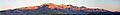
Panorama of Bare Mountain Range as seen from near State Route 374 between Beatty and Rhyolite.
See also
 In Spanish: Beatty (Nevada) para niños
