
Beetham facts for kids
Quick facts for kids Beetham |
|
|---|---|
 Early 20th century postcard of Beetham |
|

Beetham
|
|
| Population | 1,784 (2011) |
| OS grid reference | SD4979 |
| Civil parish |
|
| District |
|
| Shire county | |
| Region | |
| Country | England |
| Sovereign state | United Kingdom |
| Post town | CARNFORTH |
| Postcode district | LA7 |
| Dialling code | 01539 |
| Police | Cumbria |
| Fire | Cumbria |
| Ambulance | North West |
| EU Parliament | North West England |
| UK Parliament |
|
Beetham is a lovely village in Cumbria, England. It's located in the South Lakeland area, right near the border with Lancashire. Beetham is about 6 miles (10 km) north of Carnforth. It's also part of a special place called the Arnside and Silverdale Area of Outstanding Natural Beauty, which means it has amazing scenery. In 2011, about 1,784 people lived in the Beetham area.
Contents
A Look Back: Beetham's History
Early Days and the Domesday Book
Let's travel back in time to 1086. This was when the famous Domesday Book was written. It was a huge survey of England ordered by King William the Conqueror.
The Domesday Book shows that before 1066, a powerful person named Earl Tostig owned Beetham. He also owned many other nearby places. After the Norman Conquest, Beetham became part of the large lands owned by Roger de Poitou.
At that time, Beetham was a big area. It had about 25 "carucates" of ploughland. This was a way to measure land for farming. It was roughly 3,000 acres (1,250 hectares).
What to See and Do in Beetham
Cool Places to Visit
Beetham has several interesting spots for visitors to explore:
- The Church of St Michael and All Angels: Parts of this old church were built way back in the 12th century. That's over 800 years ago!
- The Heron Corn Mill: This is a working watermill. It still grinds grain using water power. It's also a place for arts and education.
- The Heron Theatre: This small theatre has 80 seats. It's inside an old grammar school building from the 1700s.
- The Fairy Steps: These are natural steps carved into a limestone cliff. They are in the woods west of the village. It's a fun place to explore!
- A small shrine to Saint Lioba: This little shrine is built into a stone wall. You can find it in a nearby area called Slackhead.
Beetham's Surroundings: Geography
Rivers and Historic Buildings
The River Bela flows right past Beetham village. It goes through the deer park of Dallam Tower. Then, it flows past Milnthorpe before reaching the Kent Estuary.
Just half a mile (about 0.8 km) to the south-east is Beetham Hall. This was a strong, fortified manor house from the 14th century. A "fortified manor house" means it was a large home built with defenses like thick walls. Today, much of it is in ruins, but some parts are still standing.
The Paper Factory
North of the village, there's a paper factory. It makes special kraft paper for things like medicine and food packaging. About 140 people work there.
This factory has been making paper since 1788! It has changed owners and names many times over the years. In 1964, it was the biggest producer of kraft paper in the UK.
Beetham's Wider Area: Civil Parish
Communities in the Parish
The "civil parish" of Beetham is a local government area. It includes the main villages of Beetham and Storth. It also includes smaller communities like Carr Bank, Sandside, Hale, Slackhead, Farleton, and Whasset.
Gallery
-
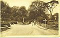
The main road into Beetham before the A6 road development
-
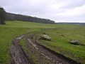
Footpath to Leighton Hall
-
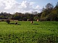
Highland cattle grazing
-
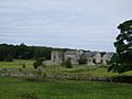
Beetham Hall in 2008


 |
River Kent | Milnthorpe | |
|
| Arnside | Holme | |||
| Yealand Redmayne |
