Craven in the Domesday Book facts for kids
Quick facts for kids Craven in the Domesday Book |
|
|---|---|
| The National Archives, Kew, London | |
 |
|
| Date | prehistory to 11th Century |
The area known as Craven in northern England has a very old name. People aren't sure if the name "Craven" comes from ancient British times, old British languages, or Roman-British times. But the name stuck around even after the Anglo-Saxons and Normans took over.
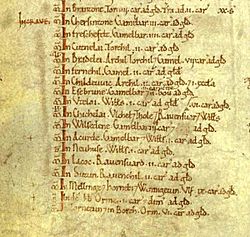
This is clear because "Craven" appears many times in the Domesday Book of 1086. Places mentioned as being "In Craven" in this book are now in North Yorkshire, and also parts of West Yorkshire, Lancashire, and Cumbria. This suggests that Craven might have been an old kingdom or a large administrative area, like a shire or earldom, that no longer exists.
Today, the Craven area is a much smaller local government district. It was created in 1974 and is entirely within North Yorkshire.
Contents
- What was Craven?
- Craven in the Domesday Book
- The King's Land in Craven
- Lands of The Clamores of Yorkshire in Craven
- Lands of William de Percy in Craven
- Lands of Gilbert Tison in Craven
- Lands of Hugh fitzBaldric in Craven
- Lands of Erneis du Buron in Craven
- Lands of Osbern D'Arques in Craven
- Lands of the King's Thegns in Craven
- Lands of Roger de Poitou in Yorkshire
What was Craven?
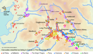
The exact size of historic Craven is a bit of a mystery. It stretched a little further southeast in Yorkshire than the modern district. However, its northwestern border is much debated.
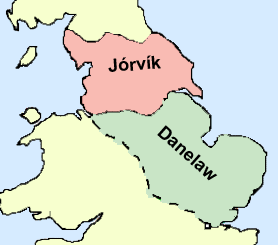
Before the Norman Conquest, a large part of northern England was ruled from York. This area was called The Kingdom of York. By 1086, after the Normans took over, they created only one big county in the North: Yorkshire. This suggests that the Norman Yorkshire was very similar to the old Kingdom of York. The Domesday Book seems to support this idea.
New counties like Lancashire, Cumberland, and Westmorland were created later, after 1086. Some historians also think that the first Yorkshire was smaller. They believe that other areas like Amounderness and Lonsdale were just added to Yorkshire in the Domesday Book to make administration easier.
Craven in the Domesday Book
The Domesday Book was like a huge survey of England. William the Conqueror ordered it in 1086. He wanted to know how much land everyone owned and how much it was worth. This helped him figure out how much tax people should pay.
Land was measured in units called carucates. A carucate was the amount of land a farmer could work in a year with a team of eight oxen. This was usually about 120 acres (50 hectares). Some carucates were marked as "Waste." This meant they were destroyed and had no people living there. Many of these areas were ruined by the Norman army during the Harrying of the North in 1069–70, about 17 years before the survey.
The King's Land in Craven
The Domesday Book lists lands owned by King William himself in Craven. Most of these were in the Airedale area, but some were in Lonsdale, which was then considered part of Yorkshire.
|
LOCATION |
CARUCATES |
PREVIOUS OWNER |
CURRENT OWNER |
Lands of The Clamores of Yorkshire in Craven
These lands were mainly around Bolton Abbey. Soon after the Domesday Book was made, they were given to Robert de Romille. The old Saxon house at Bolton Abbey was too damaged, so Romille built a new castle somewhere else: Skipton Castle.
|
LOCATION |
CARUCATES |
PREVIOUS OWNER |
SOON TO BE OWNED BY |
Lands of William de Percy in Craven
William de Percy was the founder of the very powerful House of Percy family in England.
|
LOCATION |
CARUCATES |
PREVIOUS OWNER |
CURRENT OWNER |
Lands of Gilbert Tison in Craven
By 1118, Gilbert Tison lost his lands. They went back to the King, who then gave them to other important families like Romille and Percy.
|
LOCATION |
CARUCATES |
PREVIOUS OWNER |
CURRENT OWNER |
Lands of Hugh fitzBaldric in Craven
One entry in the Domesday Book for Hugh fitzBaldric is tricky. It says "in crave" but then lists places that are far from Craven today. Hugh fitzBaldric was the High Sheriff of Yorkshire from 1069–1086, and most of his other lands were in East Yorkshire.
|
LOCATION |
CARUCATES |
PREVIOUS OWNER |
CURRENT OWNER |
Lands of Erneis du Buron in Craven
Erneis du Buron was a Norman lord who helped William the Conqueror invade England. He fought at the Battle of Hastings. In 1086, he became the High Sheriff of Yorkshire. However, between 1102 and 1118, King Henry I took his lands and gave them to the Romille family.
|
LOCATION |
CARUCATES |
PREVIOUS OWNER |
CURRENT OWNER |
Lands of Osbern D'Arques in Craven
Osbern de Arches became the High Sheriff of Yorkshire around 1100.
|
LOCATION |
CARUCATES |
PREVIOUS OWNER |
CURRENT OWNER |
Lands of the King's Thegns in Craven
A thegn was a noble person who served a king or a lord. They were below the rank of a high-reeve.
|
LOCATION |
CARUCATES |
PREVIOUS OWNER |
CURRENT OWNER |
Lands of Roger de Poitou in Yorkshire
When looking at the Domesday Book, it's hard to define Craven using Roger de Poitou's lands. His page doesn't have the "In Craven" heading. However, some of the places listed as his were described as being in Craven elsewhere in the book. For example, Thornton-in-Craven is clearly in Craven. This might have been a mistake by the person writing the book, or they just didn't repeat the heading.
Roger de Poitou's lands were very spread out. He also owned lands between the Ribble and the Mersey.
After 1102, Roger rebelled against the King. So, Henry I of England took his lands. The lands in upper Wharfedale and upper Airedale went to the Romille family. The lands in Ribblesdale and around Gisburn went to the House of Percy. Roger de Poitou had also given the Bowland to Robert de Lacy. The King let Robert de Lacy keep Bowland and gave him more land, which became the basis of the Honour of Clitheroe.
 | Bayard Rustin |
 | Jeannette Carter |
 | Jeremiah A. Brown |


