
Behchokǫ̀ facts for kids
Quick facts for kids
Behchokǫ̀
ᐯᐊᑋᐟᗱᒼᑯ
Rae-Edzo |
||
|---|---|---|
|
Tłı̨chǫ Community Government
|
||

Behchokǫ̀ on Great Slave Lake
|
||
|
||
| Motto(s):
Strong like two people
|
||

Behchokǫ̀
Location in Northwest Territories

Behchokǫ̀
Location in Canada
|
||
| Country | Canada | |
| Territory | Northwest Territories | |
| Region | North Slave | |
| Constituency | Monfwi | |
| Tlicho Community Government | 4 August 2005 | |
| Area | ||
| • Land | 75.17 km2 (29.02 sq mi) | |
| Elevation | 179 m (587 ft) | |
| Population
(2016)
|
||
| • Total | 1,874 | |
| • Density | 24,9/km2 (640/sq mi) | |
| Time zone | UTC−07:00 (MST) | |
| • Summer (DST) | UTC−06:00 (MDT) | |
| Canadian Postal code |
X0E 0Y0
|
|
| Area code(s) | 867 | |
| Telephone exchange | 292, 371, 392 | |
| - Living cost | 127.5 | |
| - Food price index | 143.9 | |
| Sources: Department of Municipal and Community Affairs, Prince of Wales Northern Heritage Centre, Canada Flight Supplement 2013 figure based on Edmonton = 100 2015 figure based on Yellowknife = 100 Elevation at the airport |
||

Behchokǫ̀ is a community in the Northwest Territories, Canada. Its name comes from the Tłı̨chǫ people and means "Behcho's place." It's officially known as the Tłı̨chǫ Community Government of Behchokǫ̀. This community is located on the Yellowknife Highway, near the northwest tip of Great Slave Lake. It is about 110 kilometers (68 miles) northwest of Yellowknife, the capital city of the Northwest Territories.
Contents
History of Behchokǫ̀
Early Encounters and Trading Posts
The first European to meet the Dogrib-speaking people was explorer Samuel Hearne in 1772. This happened when he was traveling north of Great Slave Lake. Later, in 1789, Alexander Mackenzie explored the area by canoe. He traded with the Yellowknives, another First Nations group, near the Dogrib territory.
The first trading post in this region was set up in 1789 by the North West Company. It was called Old Fort Providence and was located at the entrance of Yellowknife Bay. This post was for both the Yellowknives and the Dogrib Dene people. However, it wasn't a very busy trading spot and closed in 1823. After that, the Dogrib Dene had to trade at Hudson's Bay Company posts. These posts were on the south side of Great Slave Lake, at Fort Resolution.
Peace and New Settlements
Historically, the Dogrib and Yellowknives Dene often had disagreements. But by the 1830s, the Dogrib leader Edzo and the Yellowknives leader Akaitcho made peace. After this, the Dogrib people returned to their traditional hunting areas.
In 1852, Hudson's Bay Company set up a new trading post called Fort Rae. It was on a peninsula on the north shore of Great Slave Lake. The post was named after John Rae, a Scottish explorer. He was searching for clues about Sir John Franklin's lost expedition in the Arctic. Fort Rae became a very important trading center for the Dogrib Dene.
In the early 1900s, new traders came to the area. Ed Nagle and Jack Hislop opened a new trading post closer to where many Dene families lived. This new location became the preferred place for trade. The Hudson's Bay Company then moved its Fort Rae post next to Hislop and Nagle's.
Rae and Edzo Communities
As the community grew, with new services like a hospital and church, the government thought the land around Fort Rae wasn't good for future growth. In the 1950s, there were concerns about water pollution. So, the government suggested building a new settlement on better land. This new community was called Edzo. It was located across the Frank Channel from Fort Rae, about a 24-kilometer (15-mile) drive away.
However, most Dene families chose to stay in their original community. Because of this, Rae and Edzo became two separate places. Even though they were separate, they were managed together.
Renaming to Behchokǫ̀
On August 4, 2005, the name Rae-Edzo was officially changed to Behchokǫ̀. This name change honored important leaders in Tłı̨chǫ history. These leaders include Edzo, who made peace with the Yellowknives Dene in the 1820s. Another was Jimmy Bruneau, a respected chief in the 20th century. And Monfwi, who signed Treaty 11 with the Canadian Government in 1921. Monfwi also started the Tłı̨chǫ annual assembly in 1932.
Before 2005, the community was governed by a First Nations band government called Dog Rib Rae First Nation. With the Tłı̨chǫ Agreement, most of these responsibilities moved to the Behchokǫ̀ Community Government. However, the First Nation is still recognized by the Canadian government for Indian Act matters.
Population and People
|
||||||||||||||||||||||||||||||||||||||||||
|
||||||||||||||||||||||||||||||||||||||||||||||||||||||||||||||||||||||||||||||
In the 2021 Census, Behchokǫ̀ had a population of 1,746 people. These people lived in 460 homes. This was a small decrease from its 2016 population of 1,874. The community covers a land area of about 74.96 square kilometers (28.94 sq mi).
Who Lives in Behchokǫ̀?
According to the 2016 Census, most people in Behchokǫ̀ are Indigenous. This includes 1,695 First Nations people and 50 Métis people. Behchokǫ̀ is one of four Tłı̨chǫ communities. It is the largest Dene community in Canada. The Tłı̨chǫ land claim agreement was signed here. This agreement created the Tłı̨chǫ Government.
| Group | 2021 | 2016 | 2011 | 2006 | 2001 | |||||
|---|---|---|---|---|---|---|---|---|---|---|
| Population | % | Population | % | Population | % | Population | % | Population | % | |
| Indigenous | 1,615 | 93.35% | 1,755 | 94.1% | 1,800 | 94.24% | 1,770 | 93.9% | 1,450 | 93.85% |
| European | 75 | 4.34% | 85 | 4.56% | 100 | 5.24% | 105 | 5.57% | 95 | 6.15% |
| South Asian | 20 | 1.16% | 0 | 0% | 0 | 0% | 10 | 0.53% | 0 | 0% |
| African | 10 | 0.58% | 10 | 0.54% | 0 | 0% | 0 | 0% | 10 | 0.65% |
| East Asian | 0 | 0% | 10 | 0.54% | 0 | 0% | 10 | 0.53% | 0 | 0% |
| Southeast Asian | 0 | 0% | 0 | 0% | 0 | 0% | 0 | 0% | 0 | 0% |
| Middle Eastern | 0 | 0% | 0 | 0% | 0 | 0% | 0 | 0% | 0 | 0% |
| Latin American | 0 | 0% | 0 | 0% | 0 | 0% | 0 | 0% | 0 | 0% |
| Other/multiracial | 0 | 0% | 0 | 0% | 10 | 0.52% | 0 | 0% | 0 | 0% |
| Total responses | 1,730 | 99.08% | 1,865 | 99.52% | 1,910 | 99.17% | 1,885 | 99.52% | 1,545 | 99.55% |
| Total population | 1,746 | 100% | 1,874 | 100% | 1,926 | 100% | 1,894 | 100% | 1,552 | 100% |
| Note: Totals greater than 100% due to multiple origin responses | ||||||||||
Getting Around Behchokǫ̀
The main road in Behchokǫ̀ is Donda Tili. This road connects to the Yellowknife Highway. From there, you can go to Yellowknife or south to Fort Providence and other parts of southern Canada.
In winter, three special ice roads open up. These roads connect Behchokǫ̀ to Gamètì, Wekweètì, and Whatì to the north and west.
The closest big public airport is Yellowknife Airport. It's about an hour's drive east. There is also a private airport nearby called Rae/Edzo Airport.
Services in Behchokǫ̀
Behchokǫ̀ offers many services for its residents.
Places of Worship
- Tlicho Baptist Church
- St Michael's Catholic Church
Community Facilities
- Elizabeth Mackenzie Elementary School in Rae (for grades K-6)
- Chief Jimmy Bruneau School in Edzo (for grades K-12)
- Kǫ̀ Gocho Complex - a new recreation center
- Behchokǫ̀ Cultural Centre - a place for community events
- Tłı̨chǫ Friendship Centre
Local Businesses
- Tli Cho Hotel - for tourists and visitors
- Northern Store and Gas Bar - a general store
- F & C Services - a convenience store and stop for Frontier Coachlines
- Hyway3 Bus Charters and Freight Services - connects to Edmonton and other parts of the NWT
- Trappers Hideaway Restaurant
- Rabesca Resources Ltd - outfitters (companies that provide equipment and services for outdoor trips)
Health Services
Behchokǫ̀ does not have a hospital. The closest hospital is Stanton Territorial Hospital in Yellowknife. Basic health services are available at the Mary Adele Bishop Health Centre. There is also a private dental clinic and a center for Mental Health and Addictions Services.
Images for kids
-
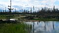
Boreal forest near Behchokǫ̀
-
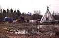
Rae Edzo - Behchokǫ̀, camp on the banks of Great Slave Lake
-
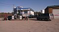
Gas station Behchokǫ̀
-
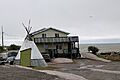
A traditional teepee beside a modern dwelling in Behchokǫ̀, with the Great Slave Lake in the background


See also
 In Spanish: Behchoko (Territorios del Noroeste) para niños
