
Bewick and Beanley Moors facts for kids
| Site of Special Scientific Interest | |
| Area of Search | Northumberland |
|---|---|
| Coordinates | 55°29′54″N 1°51′13″W / 55.498205°N 1.853601°W |
| Interest | Biological |
| Area | 3,434.95 hectares (8,500 acres) |
| Notification | 2010 |
| Location map | DEFRA MAGIC map |
Bewick and Beanley Moors is a special natural area in Northumberland, in the north-east of England. It's called a Site of Special Scientific Interest (SSSI) because of its amazing nature. This means it's a place that is protected for its plants, animals, and unique land.
The moors are very important for nature, recognized by Natural England. You'll find many different types of land here, like heaths, fens, wet grasslands, and blanket bogs. These different areas create a perfect home for many amazing animals, especially amphibians. The moors also have rare juniper trees and bushes.
This special area was officially recognized in 2010. It includes two older protected sites that are now part of Bewick and Beanley Moors. These were Hannah's Hill, Harehope (first protected in 1968) and Quarryhouse Moor Ponds (first protected in 1986).
Where are Bewick and Beanley Moors?
Bewick and Beanley Moors are actually three separate moorland areas in north Northumberland. They are located north and north-west of Alnwick. You can also find them south-east of Wooler.
The moors stretch about 8.6 miles (13.8 km) from north to south. They are up to 3.8 miles (6.1 km) wide from east to west. They are west of the A1 and east of the A697 roads.
The Southern Moor Area
The southernmost part is south-east of Beanley. It's also south of Eglingham and the B6346 road. This area is north of Bolton.
This section is shaped a bit unevenly. It's about 2.3 miles (3.7 km) from north to south and 3.0 miles (4.8 km) from east to west. Here you'll find Titlington Pike, a round hill that rises to 288 metres (945 ft) above sea level.
You can also see Titlington and Beanley Plantations. These are wet areas that gently slope down. Beanley Moor makes up most of this southern section. It's a wetland that slowly drops in height.
Kimmer and Huntersheugh Crags are steep, rocky cliffs. Kimmer Lough is a 3.2 hectares (7.9 acres) oval-shaped pond. It's a deep pond formed when a large block of ice melted a long time ago. Kimmer Crags are about 5.2 miles (8.4 km) north-east of Alnwick.
The Middle Moor Area
This is the largest section of the moors. It's north of Eglingham and south-east of Chillingham. This part stretches about 3.5 miles (5.6 km) north to south. It's also up to 3.8 miles (6.1 km) east to west.
This area includes Bewick Moor in the south. In the north-west, you'll find Hepburn Moor. Quarryhouse Moor is in the north-east. These areas rise from about 100 metres (330 ft) in the south-east.
They form a series of cliffs leading up to a wetland plateau. This plateau starts at about 210 metres (690 ft) high. Cateran Hill is a local peak here, reaching 267 metres (876 ft). At the far north-west, the site includes Ross Castle. This is a 315 metres (1,033 ft) hill near Chillingham Castle. Cateran Hill is known for the Cateran Hole.
The Northern Moor Area
This section is on the eastern slopes of the moors. It's about 2 miles (3.2 km) east of Chillingham. This part is also south of the B6348 road. It's an unevenly shaped area.
It extends about 3.2 miles (5.1 km) north to south. It's also about 2.8 miles (4.5 km) east to west. This area includes parts of Chatton Moor in the north. Sandyford Moor is in the center and south-east.
You'll also find Rossbrough Moor and Wandylaw Bog here. Part of the Wandylaw Wind Farm is within this site. The Chatton transmitting station is also located here. The moors here slowly rise from about 150 metres (490 ft) to 180 metres (590 ft) at the eastern edge. They reach local high points between 189 metres (620 ft) and 215 metres (705 ft).
Plants and Habitats
Bewick and Beanley Moors are on sandstone rock. The land slopes from 315 metres (1,033 ft) in the west to 70 metres (230 ft) in the east. This area is nationally important because it has many different types of habitats. These habitats show how the land changes from lower areas to higher moorland.
The main plants you'll see are in a wet heath. These include heather (Calluna vulgaris), purple moor-grass (Molinia caerulea), and cross-leaved heath (Erica tetralix). You might also spot deergrass (Trichophorum cespitosum), bilberry (Vaccinium myrtillus), and tormentil (Potentilla erecta). Sometimes, you'll see bog-moss (Sphagnum capillifolium).
Bogs and Wetlands
Many bogs are found in the dips and flat areas of the moors. These are waterlogged areas where peat builds up. They are very important because they are some of the easternmost examples of these habitats in Britain.
Bog sites on the moors have plants like heather and cross-leaved heath. You'll also see common and hare’s-tail cotton-grasses (Eriophorum angustifolium and E. vaginatum). Many types of bog-mosses grow here, including Sphagnum papillosum and S. magellanicum.
Less common plants include crowberry (Empetrum nigrum ssp. nigrum), cranberry (Vaccinium oxycoccos), bog asphodel (Narthecium ossifragum), and round-leaved sundew (Drosera rotundifolia).
Some bogs here change into other types of land, which is rare. For example, a bog west of Cateran Hill turns into a fen. This fen has bottle-sedge (Carex rostrata) and marsh cinquefoil (Potentilla palustris).
Wetlands are also common, especially in the east. These areas have different plants because of the limestone rock underneath. You'll find purple moor-grass and bog-myrtle (Myrica gale). Other plants include sweet vernal-grass (Anthoxanthum odoratum) and Yorkshire fog (Holcus lanatus).
Some very wet areas have plants like marsh valerian (Valeriana dioica) and butterwort (Pinguicula vulgaris). Grass-of-Parnassus (Parnassia palustris) and black bog-rush (Schoenus nigricans) also grow here.
Rocky Areas and Woodlands
Rocky areas with good drainage have plants like heather, bilberry, and bell-heather (Erica cinerea). You might also find cowberry (Vaccinium vitis-idaea) and petty-whin (Genista anglica). Lesser twayblade (Listera cordata) is found near old heather bushes.
There isn't much woodland on the moors, except for conifer plantations. The natural woodlands are mostly found along streams and at lower elevations. Trees include alder (Alnus glutinosa), hawthorn (Crataegus monogyna), and rowan (Sorbus aucuparia).
The ground under the trees has plants like yellow pimpernel (Lysimachia nemorum) and wood sorrel (Oxalis acetosella). A very special feature is one of the largest groups of juniper (Juniperus communis ssp. communis) trees in the county. This is found at Hannah's Wood.
Water Bodies and Wildlife
Kimmer Lough is the biggest body of water on the moors. It has yellow water-lily (Nuphar lutea) and reed (Phragmites communis). It's surrounded by willow trees and bog-myrtle.
Quarryhouse Moor Ponds are very important for amphibians. You can find great crested newts (Triturus cristatus), palmate newts (T. helveticus), and smooth newts (T. vulgaris). Common frogs (Rana temporaria) and common toads (Bufo bufo) also live here.
The moors are also home to the large heath butterfly (Coenonympha tullia). Many types of upland birds live here too. You can also see areas of bracken (Pteridium aquilinum) with chickweed wintergreen (Trientalis europaea).
Condition of the Moors
Bewick and Beanley Moors SSSI is divided into 25 sections for checking its health. Inspections in 2009 and 2014 showed that most sections were "unfavourable-recovering." This means they are getting better but still need care. The main problems were too much grazing by animals and burning heather in ways that weren't good for the land.
Images for kids
-
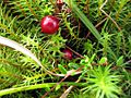
Cranberry (Vaccinium oxycoccos) on Beanley Moor
,_Beanley_Moor_-_geograph.org.uk_-_2073965.jpg)
