
Big Snow Mountain facts for kids
Quick facts for kids Big Snow Mountain |
|
|---|---|

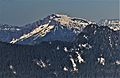
Big Snow Mountain from Snoqualmie Mountain
|
|
| Highest point | |
| Elevation | 6,680 ft (2,040 m) |
| Prominence | 1,360 ft (410 m) |
| Geography | |

Big Snow Mountain
Location in Washington (state)

Big Snow Mountain
Location in the United States
|
|
| Parent range | Cascade Range |
| Topo map | USGS Big Snow Mountain |
| Type of rock | Keechelus andesite |
| Climbing | |
| First ascent | 1917 by The Mountaineers |
| Easiest route | Scrambling |
Big Snow Mountain is a tall mountain peak in Washington state, USA. It stands about 6,680 feet (2,036 meters) high. You can find it about 7 miles (11 km) north of Snoqualmie Pass. This mountain is part of the beautiful Cascade Range and is located within the Alpine Lakes Wilderness. The land around it is managed by the Mount Baker-Snoqualmie National Forest. Water from the mountain flows into the Snoqualmie River and Skykomish River. The closest taller mountain is Overcoat Peak, which is about 3.4 miles (5.5 km) away to the southeast.
Mountain Weather: Big Snow Mountain's Climate
Big Snow Mountain is located in a special climate zone called the marine west coast climate. This means it gets a lot of influence from the Pacific Ocean. Most of the weather systems, like big clouds and storms, start over the Pacific Ocean. They then travel northeast towards the Cascade Range.
When these weather systems hit the tall Cascade Mountains, they are forced to rise. As the air goes higher, it cools down and drops its moisture. This process is called Orographic lift. It causes a lot of rain or snow to fall on the western side of the Cascades, especially in winter.
During the winter months, the weather is usually cloudy. However, in summer, high-pressure systems over the Pacific Ocean often bring clear skies. Because of the ocean's influence, the snow here tends to be wet and heavy. This can sometimes lead to a high risk of avalanches.
Mountain Formation: The Geology of Big Snow Mountain
The Alpine Lakes Wilderness, where Big Snow Mountain is located, has some very rugged land. You can see sharp peaks, long ridges, and deep valleys carved by glaciers. There are also granite rock walls and over 700 mountain lakes!
The story of how the Cascade Mountains formed goes back millions of years. It began in the late Eocene Epoch. At that time, the North American Plate was slowly moving over the Pacific Plate. This movement caused many volcanic eruptions. Also, small pieces of the Earth's crust, called terranes, came together to form the North Cascades about 50 million years ago.

Later, during the Pleistocene period (which started over two million years ago), huge sheets of ice called glaciers moved across the land many times. These glaciers carved and shaped the landscape. The last glaciers in the Alpine Lakes area started to melt and retreat about 14,000 years ago. They were north of the Canada–US border by 10,000 years ago. The "U"-shaped valleys you see today were created by these glaciers. The combination of the land pushing up (called uplift) and cracks in the Earth's crust (called faulting), along with the glaciers, created the tall peaks and deep valleys of the Alpine Lakes Wilderness.
Images for kids
-
Southwest view, from Mount Defiance
-
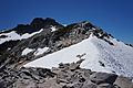
Big Snow summit detail


