
Summit Chief Mountain facts for kids
Quick facts for kids Summit Chief Mountain |
|
|---|---|

Summit Chief Mountain, north aspect
|
|
| Highest point | |
| Elevation | 7,464 ft (2,275 m) |
| Prominence | 1,324 ft (404 m) |
| Isolation | 1.28 mi (2.06 km) |
| Parent peak | Chimney Rock (7,727 ft) |
| Geography | |

Summit Chief Mountain
Location in Washington (state)

Summit Chief Mountain
Location in the United States
|
|
| Location | King County / Kittitas County Washington state, U.S. |
| Parent range | Cascade Range |
| Topo map | USGS Big Snow Mountain |
| Climbing | |
| First ascent | 1925 |
| Easiest route | Scrambling Southeast Face |
Summit Chief Mountain is a tall mountain in Washington state. It stands about 7,464 feet (2,275 metres) high. This mountain is located right on the border between King County and Kittitas County.
It is completely inside the Alpine Lakes Wilderness. This is a special protected area managed by the Mount Baker-Snoqualmie National Forest. Summit Chief Mountain is part of the Cascade Range. It is about nine miles northeast of Snoqualmie Pass.
Water from the west side of the mountain flows into the Snoqualmie River. Water from the east side goes into the Yakima River. The closest higher mountain is Chimney Rock. It is about 1.29 miles (2.08 km) to the southwest.
Weather at Summit Chief Mountain
Summit Chief Mountain is in a "marine west coast" climate zone. This means it gets a lot of weather from the Pacific Ocean. Most weather systems move from the ocean towards the Cascade Range.
When these weather systems hit the tall Cascade Mountains, they are forced to rise. As the air rises, it cools down and drops its moisture. This causes a lot of rain or snowfall on the west side of the mountains. This effect is called Orographic lift.
Because of this, the west side of the Cascades gets a lot of precipitation. This is especially true during winter, when there's a lot of snow. In winter, it's often cloudy. But in summer, high pressure systems over the Pacific Ocean bring clear skies.
The snow here tends to be wet and heavy. This can sometimes create a risk of avalanches.
How the Mountains Formed
The Alpine Lakes Wilderness has very rugged land. You can see jagged peaks, deep valleys carved by glaciers, and tall granite walls. There are also over 700 mountain lakes!
Long, long ago, huge geological events shaped this area. These events created the different landscapes and big changes in elevation. These changes also led to different climates and types of plants in various ecoregions. The land here ranges from about 1,000 feet (300 m) in lower areas to over 9,000 feet (2,700 m) on Mount Stuart.
The Cascade Range started forming millions of years ago. This was during a time called the late Eocene Epoch. The North American Plate was slowly moving over the Pacific Plate. This caused a lot of volcanic activity. Also, small pieces of the Earth's crust, called terranes, helped form the North Cascades about 50 million years ago.
About two million years ago, during the Pleistocene period, glaciers moved across the land many times. They scraped away rock and left behind debris. The last glaciers in the Alpine Lakes area started melting about 14,000 years ago. They were gone from the Canada–US border by 10,000 years ago. The U-shaped valleys you see today were carved by these glaciers.
The combination of the land pushing upwards (orogeny) and cracks in the Earth's crust (faulting), along with the glaciers, created the tall peaks and deep valleys of the Alpine Lakes Wilderness.
Gallery
-
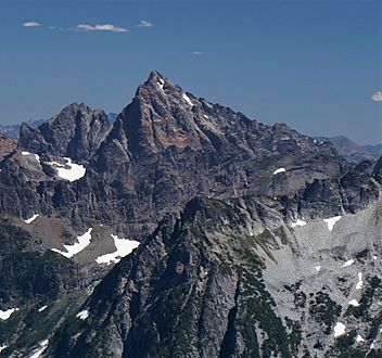
West side of Summit Chief Mountain, seen from Big Snow Mountain
-
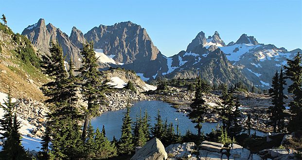
Summit Chief Mountain is on the left side, seen from Tank Lakes
-
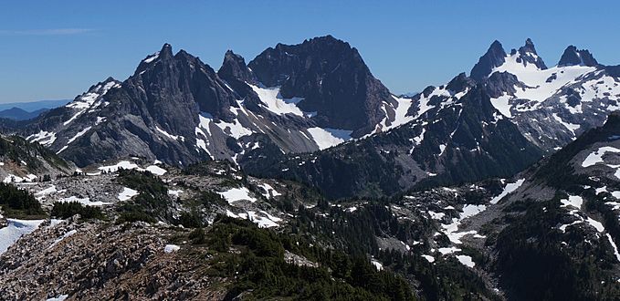
From left to right: Little Big Chief, Middle Chief, Summit Chief, Chimney Rock, Overcoat
-
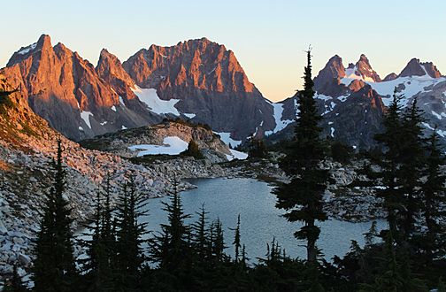
Sunset view from Tank Lakes


