Chimney Rock (Washington) facts for kids
Quick facts for kids Chimney Rock |
|
|---|---|

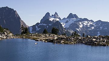
The double summit Chimney Rock centered. Summit Chief Mountain to left. Overcoat Peak to right. Lower Tank Lake in foreground.
|
|
| Highest point | |
| Elevation | 7,727 ft (2,355 m) |
| Prominence | 2,727 ft (831 m) |
| Geography | |
| Parent range | Cascade Range |
| Topo map | USGS Big Snow Mountain |
| Climbing | |
| First ascent | 27 August 1930 by Forest Farr, Art Winder and Laurence Byington |
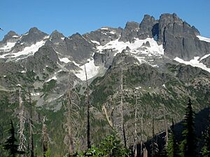
Chimney Rock is a mountain found in the Alpine Lakes Wilderness area. This wilderness is part of the Central Cascade Range in western Washington, United States. The mountain has a main peak that stands at 7,727 feet (2,355 meters) tall. It also has two smaller peaks.
Chimney Rock is about 10 miles (16 kilometers) northeast of Snoqualmie Pass. Its rocky shape makes it stand out from other mountains nearby. It sits on a ridge that separates the Snoqualmie River and Yakima River areas. Other mountains like Lemah Mountain, Summit Chief Mountain, and Overcoat Peak are close by. Chimney Rock also has three glaciers: the Overcoat Glacier, the Chimney Glacier, and another unnamed glacier.
Climbing the main peak of Chimney Rock was a big challenge for climbers in the early 1900s. In 1925, a group of climbers thought it might be impossible to reach the top. But on August 27, 1930, three climbers named Forest Farr, Art Winder, and Laurence Byington successfully reached the summit. They spent several days exploring to find their way up. This was a very impressive climb for that time! It took 10 years before anyone else reached the summit again, in 1940.
Because of the weather and how high it is, it's best to try climbing Chimney Rock in early to mid-summer. Some parts of the climb are very difficult. They need special gear and technical rock climbing skills to complete safely.
Mountain Weather
Chimney Rock is in a place with a "marine west coast" climate. This means the weather is greatly affected by the nearby Pacific Ocean. Most weather systems start over the Pacific Ocean and move towards the Cascade Range.
When these weather systems reach the tall Cascade Mountains, they are forced to rise. As the air rises, it cools down and drops its moisture as rain or snow. This is why the western side of the Cascades gets a lot of rain and especially heavy snowfall in winter.
During winter, it's usually cloudy. But in summer, high-pressure systems over the Pacific Ocean often bring clear skies. Because of the ocean's influence, the snow here tends to be wet and heavy. This can sometimes lead to a danger of avalanches.
How the Mountains Formed
The Alpine Lakes Wilderness has some very rugged land. You can see jagged peaks, deep valleys carved by glaciers, and tall granite walls. There are also over 700 mountain lakes!
The amazing landscape and big changes in elevation in the Cascade Range were created by geological events millions of years ago. These changes also led to different climates and types of plants in the area. The land here ranges from about 1,000 feet (300 meters) high to over 9,000 feet (2,700 meters) on Mount Stuart.
The Cascade Mountains started forming millions of years ago. This happened when the North American Plate (a huge piece of Earth's crust) slowly moved over the Pacific Plate. This movement caused volcanoes to erupt over time. Also, small pieces of Earth's crust called "terranes" joined together to form the North Cascades about 50 million years ago.
More recently, over two million years ago, during the Pleistocene period, glaciers moved across the land many times. As they moved, they scraped away rock and left behind rock debris. The last time glaciers retreated from the Alpine Lakes area was about 14,000 years ago. The U-shaped valleys you see in the rivers today were formed by these glaciers. The combination of land uplift, cracks in the Earth's crust (faulting), and glaciers has created the tall peaks and deep valleys of the Alpine Lakes Wilderness.
 | Jackie Robinson |
 | Jack Johnson |
 | Althea Gibson |
 | Arthur Ashe |
 | Muhammad Ali |


