Lemah Mountain facts for kids
Quick facts for kids Lemah Mountain |
|
|---|---|

Lemah Mountain
|
|
| Highest point | |
| Elevation | 7,480+ ft (2,280+ m) |
| Prominence | 960 ft (290 m) |
| Geography | |
| Location | King / Kittitas counties, Washington, U.S. |
| Parent range | Cascade Range |
| Topo map | USGS Chikamin Peak |
| Geology | |
| Volcanic arc/belt | Snoqualmie Crest, Cascade Volcanic Arc |
| Last eruption | N/A |
| Climbing | |
| First ascent | 1923 by Wallace Burr and party |
| Easiest route | Rock/ice climb |
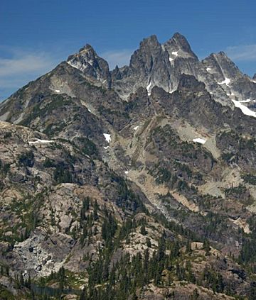
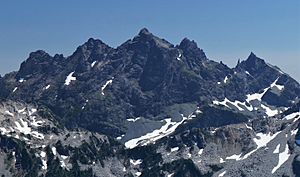
Lemah Mountain is a cool mountain peak in the Snoqualmie Crest, which is part of the North Cascades Mountains in Washington. It's located about 7.7 miles (12.4 km) from Snoqualmie Pass. Lemah Mountain is special because it has five different tops, or "summits"!
Its name, Lemah, comes from an old language called Chinook Jargon. This word was taken from the French words le main, meaning "the hand." Lemah Mountain was formed when huge pieces of the Earth's crust, called plates, slowly crashed into each other over millions of years.
Contents
The Five Summits of Lemah
Lemah Mountain isn't just one peak; it has five separate summits! The highest one is over 7,480 feet (2,280 meters) above sea level. These five peaks are:
- Lemah One (6,960 feet or 2,121 meters)
- Lemah Two (7,280 feet or 2,219 meters)
- Main Peak (7,512 feet or 2,290 meters), also called Lemah Three
- Lemah Four (7,200 feet or 2,195 meters)
- Lemah Five (7,040 feet or 2,146 meters)
Each of these summits has its own path for climbers. The Main Peak, which is the tallest, was first climbed in 1923.
Glaciers and Waterways
The Lemah Glacier sits on the eastern side of Lemah Mountain. This glacier is mostly split into three parts today. Lemah Creek, a stream named after the mountain, flows from this glacier. It eventually joins the Cooper River.
Another stream, Burnt Boot Creek, also flows from Lemah Mountain. It is also a branch of the Cooper River. On the western side of Lemah Mountain, you can find a small body of water called Avalanche Lake.

First Climbs
People have been climbing Lemah Mountain for a long time!
- The main summit of Lemah Mountain was first climbed on July 7, 1923. A group led by Wallace Burr made this first ascent.
- Lemah One, also known as Lemah Thumb or Iapia Peak, was first climbed in 1925 during a Mountaineer outing.
- On the eastern side of Lemah Two, there are two rock towers. The taller one, called Goatshead Spire (7,000 feet or 2,134 meters), was first climbed on August 8, 1982. Donald Goodman and John Mason were the first to reach its top.
Mountain Weather
Most of the weather we experience starts over the Pacific Ocean. These weather systems then travel east towards the Cascade Mountains. When they reach the tall peaks of the Cascades, the air is forced to rise. As the air goes higher, it cools down and drops its moisture. This causes a lot of rain or snow to fall on the Cascades. This process is called Orographic lift.
Because of this, the Cascades get a lot of precipitation, especially heavy snowfall in the winter. During winter, the weather is usually cloudy. However, in the summer, high-pressure systems over the Pacific Ocean become stronger. This often leads to clear skies and sunny weather.
How Lemah Mountain Formed
Lemah Mountain is located in the Alpine Lakes Wilderness. This area has some very rugged land, with sharp peaks, long ridges, and deep valleys carved by glaciers. You can also see tall granite spires and over 700 mountain lakes here! All these different landforms and big changes in elevation were created by geological events that happened millions of years ago. These events also led to different climate zones across the Cascade Range.
The Cascade Mountains began to form millions of years ago, during the late Eocene Epoch. At that time, the North American Plate was slowly moving over the Pacific Plate. This movement caused many volcanic eruptions and other geological activity. Also, small pieces of the Earth's crust, called terranes, came together to form the North Cascades about 50 million years ago.
Later, during the Pleistocene period (which started over two million years ago), huge sheets of ice called glaciers moved across the land many times. As these glaciers advanced and then melted back, they scraped and shaped the landscape. They left behind piles of rock and debris. The last time glaciers melted in the Alpine Lakes area was about 14,000 years ago. By 10,000 years ago, they had moved north of the Canada–US border. The "U"-shaped valleys you see in the rivers today were created by these recent glaciers.
The combination of the land being pushed up (called uplift) and cracks forming in the Earth's crust (called faulting), along with the action of glaciers, has created the tall peaks and deep valleys of the Alpine Lakes Wilderness area.
 | Emma Amos |
 | Edward Mitchell Bannister |
 | Larry D. Alexander |
 | Ernie Barnes |

