Bingham County, Idaho facts for kids
Quick facts for kids
Bingham County
|
|
|---|---|

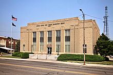
United States Post Office in Blackfoot, Idaho.
|
|

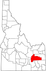
Location within the U.S. state of Idaho
|
|
 Idaho's location within the U.S. |
|
| Country | |
| State | |
| Founded | January 13, 1885 |
| Named for | Henry H. Bingham |
| Seat | Blackfoot |
| Largest city | Blackfoot |
| Area | |
| • Total | 2,120 sq mi (5,500 km2) |
| • Land | 2,094 sq mi (5,420 km2) |
| • Water | 26 sq mi (70 km2) 1.2% |
| Population
(2020)
|
|
| • Total | 47,992 |
| • Estimate
(2022)
|
49,923 |
| • Density | 23/sq mi (9/km2) |
| Time zone | UTC−7 (Mountain) |
| • Summer (DST) | UTC−6 (MDT) |
| Congressional district | 2nd |
Bingham County is a place in Idaho, a state in the United States. In 2020, about 47,992 people lived there. The main city, and also the largest, is Blackfoot.
Bingham County is part of a larger area that includes Idaho Falls and Rexburg.
Contents
History of Bingham County
Bingham County was started on January 13, 1885. It was named after Henry H. Bingham. He was a congressman from Pennsylvania. He was also a friend of William Bunn, who was Idaho's governor at the time.
The county was first formed from Oneida County. Later, parts of Bingham County were used to create other counties. These include Bannock (in 1893), Fremont (1893), Bonneville (1911), Power (1913), and Butte (1917).
Geography and Nature
Bingham County covers about 2,120 square miles. Most of this area is land, with about 26 square miles of water.
The Snake River flows through the middle of Bingham County. It goes southwest towards the American Falls Reservoir. In the southeast part of the county, you'll find the Blackfoot Reservoir and Dam. This dam holds back the waters of the Blackfoot River. Water from the Blackfoot Dam flows into the Snake River.
You can also see smaller hills called buttes in the Snake River Plain. These are the East Butte and the Middle Butte. They are located south of US Route 20.
Neighboring Counties
Bingham County shares borders with these other counties:
- Jefferson County - north
- Bonneville County - east
- Caribou County - southeast
- Bannock County - south
- Power County - southwest
- Blaine County - west
- Butte County - northwest
Main Roads
Several important highways pass through Bingham County:
People of Bingham County
| Historical population | |||
|---|---|---|---|
| Census | Pop. | %± | |
| 1890 | 13,575 | — | |
| 1900 | 10,447 | −23.0% | |
| 1910 | 23,306 | 123.1% | |
| 1920 | 18,310 | −21.4% | |
| 1930 | 18,561 | 1.4% | |
| 1940 | 21,044 | 13.4% | |
| 1950 | 23,271 | 10.6% | |
| 1960 | 28,218 | 21.3% | |
| 1970 | 29,167 | 3.4% | |
| 1980 | 36,489 | 25.1% | |
| 1990 | 37,583 | 3.0% | |
| 2000 | 41,735 | 11.0% | |
| 2010 | 45,607 | 9.3% | |
| 2020 | 47,992 | 5.2% | |
| 2023 (est.) | 50,395 | 10.5% | |
| U.S. Decennial Census 1790–1960, 1900–1990, 1990–2000, 2010–2020 |
|||
2010 Census Information
In 2010, there were 45,607 people living in Bingham County. There were about 15,000 households. The population density was about 21.8 people per square mile.
Most people in the county were white (80.6%). Other groups included American Indian (6.5%), Asian (0.6%), and Black (0.2%). About 17.2% of the population was of Hispanic or Latino background. Many people had ancestors from England (22.3%) or Germany (12.7%).
About 43.6% of households had children under 18 living with them. The average household had 3.02 people. The average age of people in the county was 31.8 years old.
Cities and Towns
Cities
Census-Designated Places (CDPs)
These are areas that are like towns but are not officially incorporated as cities.
Other Communities
These are smaller, unincorporated places in the county:
- Alridge
- Atomic City
- Cerro Grande
- Clarkson
- Coffee Point
- Collins
- Jameston
- Gibson
- Goshen
- McDonaldville
- Morgan
- Pingree
- Rising River
- Rose
- Springfield
- Sterling
- Thomas
- Wapello
- Wolverine
- Woodville
Education
Students in Bingham County attend schools in several different school districts:
- Aberdeen School District 58
- Blackfoot School District 55
- Bonneville Joint School District 93
- Firth School District 59
- Shelley Joint School District 60
- Snake River School District 52
A part of Bingham County is also served by the College of Eastern Idaho.
See also
 In Spanish: Condado de Bingham para niños

