
Blackbeard Peak facts for kids
Quick facts for kids Blackbeard Peak |
|
|---|---|

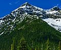
Blackbeard Peak seen from the northeast on the North Cascades Highway
|
|
| Highest point | |
| Elevation | 7,241 ft (2,207 m) |
| Prominence | 361 ft (110 m) |
| Geography | |

Blackbeard Peak
Location in Washington (state)

Blackbeard Peak
Location in the United States
|
|
| Location | Skagit County, Washington, United States |
| Parent range | North Cascades |
| Topo map | USGS Mount Arriva |
| Climbing | |
| Easiest route | Scrambling |
Blackbeard Peak, sometimes spelled Black Beard Peak, is a tall mountain in the North Cascades mountain range. It stands 7,241 feet (2,207 meters) high. You can find it in Skagit County, in the state of Washington, United States.
This peak is part of the Okanogan National Forest. It's located northwest of Rainy Pass and southeast of Graybeard Peak. Its closest taller neighbor is Repulse Peak, which is about 1.06 miles (1.71 km) to the west. You can easily see Blackbeard Peak from the North Cascades Highway. Rain and melting snow from Blackbeard Peak flow into Granite Creek, which then joins the Skagit River.
What's the Weather Like?
Most of the weather in this area comes from the Pacific Ocean. These weather systems move northeast towards the Cascade Mountains. When they reach the North Cascades, the tall peaks force the air upwards. This process, called orographic lift, makes the air cool down and drop its moisture. That's why the western side of the North Cascades gets a lot of rain or snow.
During winter, it's usually cloudy and snowy. But in summer, high-pressure systems over the Pacific Ocean often bring clear, sunny skies. Because the ocean influences the weather, the snow here tends to be wet and heavy. This can lead to a high risk of avalanches.
How Blackbeard Peak Was Formed
The North Cascades are known for their rugged landscape. They have sharp peaks, rocky ridges, and deep glacial valleys. These features were created by amazing geological events that happened millions of years ago. These events caused huge changes in the land's height, which also led to different climates. These climate differences then created the various plant zones, or ecoregions, we see today.

The story of how the Cascade Mountains formed began millions of years ago. This was during the late Eocene Epoch. At that time, the North American Plate was slowly moving over the Pacific Plate. This movement caused many volcanic eruptions. Also, small pieces of the Earth's crust, called terranes, came together. These pieces helped form the North Cascades about 50 million years ago.
Later, during the Pleistocene period, which started over two million years ago, glaciers played a big role. Huge sheets of ice moved across the land many times. As they moved, they carved out the landscape and left behind rock debris. The "U"-shaped valleys you see today were formed by these glaciers. The combination of the land being pushed up (uplift) and breaking apart (faulting), along with the glaciers, created the tall peaks and deep valleys of the North Cascades.
Images for kids
-
Blackbeard Peak

