
Repulse Peak facts for kids
Quick facts for kids Repulse Peak |
|
|---|---|

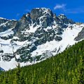
Repulse Peak seen from the North Cascades Highway
|
|
| Highest point | |
| Elevation | 7,923 ft (2,415 m) |
| Prominence | 523 ft (160 m) |
| Isolation | 0.56 mi (0.90 km) |
| Geography | |

Repulse Peak
Location in Washington (state)

Repulse Peak
Location in the United States
|
|
| Location | Border of Chelan and Skagit Counties, Washington, United States |
| Parent range | North Cascades |
| Topo map | USGS Mount Arriva |
| Climbing | |
| First ascent | 1971, Firey, Swanson |
| Easiest route | Scrambling |
Repulse Peak is a tall mountain in Washington state, standing 7,923 feet (about 2,415 meters) high. It's part of the North Cascades mountain range. You can find it right on the edge of the Stephen Mather Wilderness and North Cascades National Park.
The peak is located between Black Peak and Fisher Peak. You can often see it from the North Cascades Highway. Rain and melting snow from Repulse Peak flow into streams that feed the Skagit River and Stehekin River.
What's the Weather Like?
Repulse Peak is in a special climate zone called the "marine west coast" climate. This means it gets a lot of moisture from the Pacific Ocean. Most of the weather comes from the Pacific Ocean, moving towards the Cascade Mountains.
When air from the ocean hits the tall North Cascades, it's forced to rise. This makes the air cool down and drop its moisture as rain or snow. So, the western side of these mountains gets a lot of rain and snow, especially in winter.
Winters are often cloudy. But in summer, high pressure over the Pacific Ocean usually brings clear, sunny skies. Because it's close to the ocean, the snow here is often wet and heavy. This can make avalanches more likely.
How the Mountains Formed
The North Cascades are known for their rugged look. They have sharp peaks, rocky ridges, and deep valleys carved by glaciers. These mountains were formed over millions of years by huge geological events. These events created the different landscapes and big changes in height, which also led to different climates and types of plants in the area.
The Cascade Mountains started forming millions of years ago, during a time called the late Eocene Epoch. This happened because the North American Plate (a huge piece of Earth's crust) was slowly moving over the Pacific Plate. This movement caused a lot of volcanic activity. Also, smaller pieces of Earth's crust, called terranes, came together to help form the North Cascades about 50 million years ago.
About two million years ago, during the Pleistocene period, huge sheets of ice called glaciers moved across the land. They advanced and then melted back many times. As they moved, they scraped and shaped the landscape, leaving behind rock debris. The "U"-shaped valleys you see in the rivers here were created by these glaciers. The lifting of the land (called uplift) and cracks in the Earth's crust (called faulting), along with the glaciers, are the main reasons why the North Cascades have such tall peaks and deep valleys today.
Images for kids
-
Repulse Peak
-
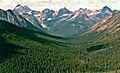
Repulse Peak (center) seen from the Pacific Crest Trail. Black Peak is on the left.


