
Fisher Peak (Washington) facts for kids
Quick facts for kids Fisher Peak |
|
|---|---|

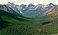
Fisher Peak seen from the North Cascades Highway
|
|
| Highest point | |
| Elevation | 8,040 ft (2,451 m) |
| Prominence | 720 ft (220 m) |
| Isolation | 1.02 mi (1.64 km) |
| Geography | |

Fisher Peak
Location in Washington (state)
|
|
| Location | Chelan / Skagit Counties Washington, United States |
| Parent range | North Cascades |
| Topo map | USGS Mount Arriva |
| Climbing | |
| First ascent | 1940, Fred Beckey, Jim Crooks, Ed Kennedy |
| Easiest route | Scrambling |
Fisher Peak is a tall mountain peak in the Cascade Range in Washington State, USA. It sits right on the edge of the Stephen Mather Wilderness and North Cascades National Park. You can find it between Black Peak and Easy Pass, next to Repulse Peak. Water from Fisher Peak flows into streams that eventually join the Skagit River.
What's the Weather Like on Fisher Peak?
Fisher Peak is in a special weather area called a marine west coast climate. This means it gets a lot of moisture from the Pacific Ocean. Most weather systems start over the Pacific and move towards the Cascade Mountains.
When these weather systems hit the tall peaks of the North Cascades, the air is forced to rise. As it rises, it cools down and drops its moisture. This causes a lot of rain or snowfall on the mountains.
The western side of the North Cascades gets a lot of precipitation, especially heavy snowfall in winter. Winters are often cloudy. However, in summer, high-pressure systems over the Pacific Ocean bring clear skies. Because of the ocean's influence, the snow is often wet and heavy. This can create a high risk of avalanches.
How Were the North Cascades Formed?
The North Cascades mountains have very rugged shapes. You can see jagged peaks, sharp ridges, and deep valleys carved by glaciers. These amazing landscapes were created by geological events that happened millions of years ago. These events caused big changes in elevation and led to different climates.
The formation of the Cascade Mountains began millions of years ago, during the late Eocene Epoch. The North American Plate slowly moved over the Pacific Plate. This movement caused many volcanic eruptions.
Also, small pieces of the Earth's crust, called terranes, crashed into North America. These collisions helped build the North Cascades about 50 million years ago.
During the Pleistocene period, which started over two million years ago, glaciers grew and shrank many times. As they moved, they scraped away the land, leaving behind rock debris. The "U"-shaped valleys you see today were carved out by these glaciers. The combination of land uplift, faulting, and glaciation created the tall peaks and deep valleys of the North Cascades.
Images for kids
-
Fisher Peak (center) with Black Peak (left) and Graybeard Peak (right) seen from the Pacific Crest Trail above Swamp Creek

