Blacksyke Tower facts for kids
Quick facts for kids Blacksyke Tower Engine House |
|
|---|---|
| Riccarton, East Ayrshire, Scotland UK grid reference NS415352 |
|
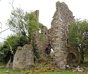
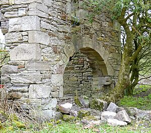
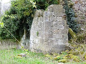
Remnants of Blacksyke Tower
|
|
| Coordinates | 55°35′06″N 4°30′54″W / 55.5851°N 4.5151°W |
| Type | A mock Scottish Tower house or castle |
| Site information | |
| Owner | Caprington Golf Club |
| Open to the public |
Yes |
| Condition | A ruin |
| Site history | |
| Built | 18th century |
| Built by | Cunninghames of Caprington Castle |
| In use | 18th and 19th centuries |
| Materials | Stone |
The Blacksyke Tower is also known as the Blacksyke Engine House or Lusk's Folly. It's a very old building in Riccarton, Scotland. This tower is a special historic site because it shows how coal and lime were mined long ago.
What makes it unique is its design. It looks like a mock Gothic tower house or a small castle. But it was actually an engine house! This style is very rare for an engine house. Built in the late 1700s, it's one of the oldest of its kind in the United Kingdom. You can still see the old tracks where wagons carried coal and lime away.
Contents
History of Blacksyke Tower
In Scots, a 'syke' means a small stream. This stream often dries up in summer. It usually flows through a low or boggy area. The word 'black' might mean the ground was peaty. This description fits the area around the tower, which often flooded.
What was Blacksyke Tower For?
The Blacksyke Tower was built to hide a powerful machine. This machine was a Newcomen atmospheric pumping engine. Its job was to pump water out of the coal mines. The area was low-lying, so water often got into the mine shafts.
The owners of Caprington Castle wanted the engine house to look nice. So, they designed it to look like a folly. A folly is a building made to look like an old ruin or castle. It's built just for decoration. Even though it was far from the castle, it blended into the estate. The top part of the building was added later. This made it look even more like a romantic old ruin. You can see the different types of stone used in the walls.
The engine was bought from Carron Iron Works. At the time, more efficient Boulton and Watt steam engines were available. But Newcomen engines didn't require an annual patent payment. Also, coal was easy to find right there. The Newcomen engine could drain the mine down to about 50 metres. This was deep enough for miners to work the Blind Coal seam.
The Tower's Castle-like Features
The builders paid great attention to making the engine house look like a real tower house. The walls are not very thick. It had a supposedly vaulted ground floor. There was a water spout and windows placed in different spots. It also had a decorative corbelled parapet on two sides. The roof had crow-stepped gables. On the north-east side, there was a turret. This turret was actually a chimney. You can still see soot inside it. It had two flues for smoke, one from inside the main building.
The tower is a rectangle, about 6 by 8 metres. Its walls are about 0.7 metres thick. They were built with rough stones. The corners have smooth, dressed stones called quoins. The south-facing gable end has a crow-step feature. This feature is slightly off-centre from the main wall. It also shows where the roof used to be. The stone quality suggests that the castle-like features were added later. They were built onto what was first a normal engine house.
A smaller building is attached to the west side of the tower. It also has decorative corbels. This building might have held coal or a boiler and furnace. It seems to be a later addition. It covers up a window that was once in the main tower. There's also an entry to the soot-stained chimney flue here. This shows a fire was present, producing waste gases. A more powerful James Watt steam engine would need a bigger boiler. This would explain the need for this new building and its connection to the chimney. James Watt's patent ended in 1800.
A large arch lets you into the ground floor on the south side. This was common for engine houses. An old map from the 1850s shows a lean-to building on the east side. It also shows two rectangular water pools nearby. A path ran from the engine house to a small square building.
A flag pole on the tower was used to signal when coal was ready. Wagons would then be brought to the colliery. This made it an early type of signal box. It's also thought that tokens were exchanged at the tower. This helped keep track of how many loads of coal were produced. A coal pit was located just east of the tower.
Over the years, the tower has been changed many times. Several windows and a door were blocked up with stone. It was used as a storage building. The tower is near other buildings that included a school. This school later became a Sunday school. These changes suggest the tower was used for different purposes later on. It's believed the building served as a workshop for the coalfield. The nearby buildings were offices. The remains of a flag pole are still on the north-east turret. The school might have also been used by children from Earlston. Earlston is nearby and was easy to reach by the old railway track.
The Earlston Newcomen Engine
There was another Newcomen Atmospheric Beam engine. This one was from the 1770s. It was located at the 'Caprington Colliery' in Earlston. This engine is now in the National Museum of Scotland. An old photo of its engine house doesn't look like the Blacksyke Tower.
Colonel Cunninghame of Caprington gave this engine to the town of Kilmarnock in 1901. It had worked for 95 years! After some repair work, it was kept in the Dick Institute for many years. Later, it was considered unsafe. So, it was given to the National Museum of Scotland in 1958. In 1998, it was restored. Now it's on display with a partial replica engine house. It's powered by electricity.
The engine's wooden beam was replaced with a cast-iron one in 1837. Its cast iron cylinder was 96 inches long. It had a 30-inch bore and a stroke of 54 to 60 inches. It's not clear where the water was pumped. No streams are shown nearby. However, two artificial water pools or tanks are shown close by.
The Lime Kilns
There were two lime kilns at Blacksyke. They are shown on the first 1860 OS map. But they were no longer used by 1897. The tracks for wagons were also removed by then. An inclined bank led up to the top of the lime kilns. Wagons would carry coal and limestone up this bank. This was to fill the kilns.
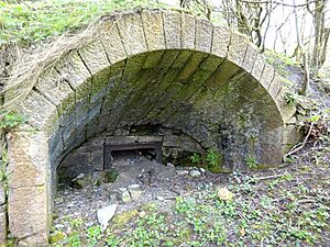
The openings of the kilns, called 'kiln eyes', are still in good condition. It's unusual that the rectangular iron box and grate bars are still there. This is where the quicklime was removed. This was a dangerous job, especially in wet weather. A railway line ran to the north-west and north-east. The lime kilns sat in a V-shaped area between these lines.
Poor-quality coal was often used in the kilns. The smoke from them was very polluting. The kilns operated continuously for about a week at a time. This made them a constant hazard. Water was added to the quicklime. The resulting slaked lime was used to paint walls. It was also spread on acidic ground. This helped reduce acidity and improve the soil. Quicklime could also be spread directly on the ground. In the 1700s, using it was often a requirement in farm leases.
The Rail Network
Sir William Cunninghame of Caprington Castle opened a railway line in 1818. It was called the Fairlie Branch. This 4-kilometre (2.5-mile) line was for horse-drawn wagons. It connected to the Kilmarnock and Troon Railway. It crossed the River Irvine to reach the collieries in the Fairlie area. The Blacksyke Tower was built before this time. However, it might have been changed later.
This line later became a standard gauge railway. It was part of the Glasgow and South-Western Railway. It had many lines serving at least nine coal pits. One line ran through Earlston to Blacksyke and beyond.
By 1896, the tracks on the 'Earlston' branch were removed. But the line remained in use as far as the Earlston sawmill. Part of the old line is now a public footpath. Its route is marked by single or double hedgerows.
Blacksyke and the Miners' Homes
The ruins of a large, U-shaped building are at Blacksyke. This was probably a farm. It's located close to the tower, slightly to the south-east. It was once connected by a lane to the nearby Ayr Road. An attached building is shown on 1896 OS maps as a school. This school was for the children of coal miners and estate workers. By 1908, it was shown as a Sunday School. This was because the local coal pits had closed. The OS Name Book from 1855-57 says the old farm was used by workers. They were employed by Thomas Smith Cunningham Esq. of Caprington Castle.
The Burnbank miners' homes were called the 'Peace and Plenty'. They stood on the Ayr Road opposite Loreny. Blacksyke is shown on Thomson's 1832 map. A small group of miners' homes called Laputa was further down the west side of the road to Ayr. This unusual name might come from the flying island of Laputa. This island is in the 1726 book Gulliver's Travels by Jonathan Swift.


