
Bledsoe's Station facts for kids
Quick facts for kids |
|
|
Bledsoe's Station
|
|

The site of Bledsoe's Station
|
|
| Location | Castalian Springs, Tennessee, US |
|---|---|
| Nearest city | Gallatin, Tennessee, US |
| Built | c. 1781–1783 |
| NRHP reference No. | 92000970 |
| Added to NRHP | July 30, 1992 |
Bledsoe's Station, also known as Bledsoe's Fort, was an old fort from the 1700s. It was a fortified settlement built by white pioneers in what is now Castalian Springs, Tennessee. A famous hunter and pioneer named Isaac Bledsoe (born around 1735, died 1793) built the fort in the early 1780s. Its purpose was to protect new settlers in the Upper Cumberland area from attacks by Native American groups.
The fort itself is no longer standing today. However, archaeologists have found its exact location through digging. This site is now part of Bledsoe's Fort Historical Park. This public park was created in 1989 by local residents and descendants of the Bledsoe family.
Bledsoe's Station was one of many forts built in the Upper Cumberland region. These forts appeared after the American Revolutionary War when many European-American settlers moved into Middle Tennessee. The fort was a useful stopping point on Avery's Trace. This was the main road connecting East and Middle Tennessee at that time.
More settlers moving into the area led to conflicts with Native American groups who already lived there. Many settlers were killed in the late 1780s and early 1790s. Isaac Bledsoe's brother, Anthony Bledsoe, was killed at the fort in 1788. Isaac himself was killed in 1793 while working in a field outside the fort. The fighting largely ended in 1794 with the end of the Cherokee–American wars. This made the fort less necessary for protection.
Bledsoe's Fort Historical Park protects the fort's excavation site. You can still see the outline of the fort's walls from old digging trenches. The park also has several historic buildings. These include the Nathaniel Parker Cabin and Hugh Rogan Cottage. Both Parker and Rogan were friends of Isaac Bledsoe. There is also a pioneer cemetery with a large monument for the Bledsoe brothers. Other important historical sites are nearby. The Castalian Springs Mound Site and the Wynnewood State Historic Site are just east of the park. The Cragfont State Historic Site is just to the west.
Contents
Where is Bledsoe's Station Located?
Bledsoe's Station was built on a hill. Bledsoe Creek is to the west of the hill, and Bledsoe Lick Creek is to the east. Both of these streams flow into the Old Hickory Lake part of the Cumberland River. This is about a mile south of the fort site. The hill has open fields and thick forests. The top of the hill is used for flying radio-controlled airplanes. A natural spring, which provided minerals for Bledsoe's Lick, flows at the base of the hill. This is a few hundred yards east of where the fort was.
Bledsoe's Fort Historical Park covers most of this hill. It is between the Sumner County RC Flyers airfield and Rock Springs Road. Tennessee State Route 25, also known as Hartsville Pike, forms the park's southern border and is the main way to get there. The park is about halfway between Hartsville (to the east) and Gallatin (to the west). It is about 35 miles (56 km) northeast of Nashville.
A Look Back: History of the Area
Who Lived Here First? Native American Settlements

For thousands of years, the mineral springs at Bledsoe's Lick attracted large animals like buffalo. This also brought Native American hunters to the area. Native Americans hunted around Bledsoe's Lick as far back as 12,000 years ago. This was during the Paleo-Indian period. They camped there off and on during the Archaic (8000-1000 BC) and Woodland (1000 BC - 1000 AD) times.
During the Mississippian period (around 1000–1450 AD), a large village was built. It was at the Castalian Springs Mound Site, just a few hundred yards from the mineral springs. This village covered 40 acres (0.16 km2) and had at least 12 mounds. When the first European-American explorers arrived in the mid-1700s, the Cherokee, Chickasaw, and Creek tribes used the area as a hunting ground.
Early Explorers and Hunters
Some of the first English-American explorers in the Upper Cumberland region were called long hunters. They got this name because their hunting trips lasted a very long time. These hunters usually followed the Cumberland River from southwestern Virginia into Middle Tennessee.
Expeditions led by Henry Skaggs in 1765 and James Smith in 1766 passed through what is now Sumner County, Tennessee. They hunted a lot in the Upper Cumberland area. In 1769, an expedition led by Kasper Mansker spent several months there. They even sent two canoes full of animal furs downriver to Natchez, Mississippi. Mansker came back to the Upper Cumberland in 1771 with a bigger group of hunters, including Isaac Bledsoe. They collected thousands of animal skins.
In 1772, Mansker and Bledsoe led a third trip. This group set up a main camp along Station Camp Creek. This creek is a few miles west, near Gallatin, and got its name from their camp. During this trip, Bledsoe followed old buffalo paths to the creek and salt lick that are now named after him. This is where he would later build his fort.
In the late 1770s, another long hunter, Thomas "Bigfoot" Spencer, camped near Bledsoe's Lick. Spencer stayed through 1778, spending the winter inside a hollowed-out sycamore tree. This tree was just south of the mineral springs. Spencer spent much of that year building cabins in the area. He wrongly believed that building cabins would let him claim the land.
Settlers Arrive and Conflicts Begin

Isaac and Anthony Bledsoe were brothers born in Virginia in the early 1730s. Anthony Bledsoe, the older brother, fought in the French and Indian War. He also served in the Virginia militia. He was in charge of Fort Patrick Henry in 1776. The next year, he was elected to the Virginia House of Delegates. Isaac Bledsoe also fought in the French and Indian War. After his hunting trips in the early 1770s, he joined William Christian's expedition against the Cherokee in 1776. In 1779, North Carolina asked Anthony Bledsoe to lead a group to survey land in Middle Tennessee. Isaac Bledsoe followed in 1781.
Isaac Bledsoe likely started building Bledsoe's Station soon after he arrived. However, he didn't move his family into the fort until 1783. Around the time Bledsoe's Station was finished, Anthony Bledsoe built a fort at Greenfield. This was about 2.5 miles (4.0 km) north of Isaac's fort.
As more settlers came to the Upper Cumberland region, conflicts with Native American groups grew. The Chickamauga Cherokee were a group of Cherokee who had been at war with the United States since 1776. They did not want European-American settlers to move permanently into Middle Tennessee.
In 1782, a frontiersman named Hugh Rogan was almost killed in an ambush near what is now Cragfont. A hunting group led by Thomas Spencer was attacked in 1784. Spencer survived that attack, but was later killed in another ambush. In 1786, Anthony Bledsoe wrote to the governor of North Carolina. He reported that 14 settlers had been killed that year. He asked for permission to attack the Chickamaugas.
A schoolteacher named George Hamilton was shot and badly hurt at Bledsoe's Station in 1787. As attacks increased, Anthony Bledsoe moved his family from Greenfield to Bledsoe's Station. It offered better protection. But in 1788, he was shot and badly wounded when he accidentally stepped into a part of the fort that was open to enemy fire. Hugh Rogan, who was at the fort, bravely snuck out to a nearby fort to get supplies. This helped them make a fire so the dying Bledsoe could write his will.
Conflicts between the Chickamaugas and the settlers continued into the early 1790s. Ziegler's Fort was taken over in 1792. Morgan's Station was almost burned a few months later. In 1793, Isaac Bledsoe was shot and killed while walking in a field near Bledsoe's Station. The next year, two of Anthony Bledsoe's relatives were ambushed and killed near Rock Castle. This is now Hendersonville. Thomas Bledsoe, another of Anthony's sons, was ambushed and killed a few months later. The fighting finally stopped when the Treaty of Tellico ended the Cherokee–American wars in 1794.
The First Road and New Owners

The first major road connecting the Upper Cumberland region to settlements in the east was finished in 1788. It was called Avery's Trace. This road connected Fort Southwest Point with Nashville. It passed just a few hundred feet east of Bledsoe's Station.
Important visitors to Bledsoe's Station in the 1790s included the French botanist André Michaux. Also, Louis-Philippe, Duke of Orléans, who later became king of France, visited. General James Winchester bought Bledsoe's Station in 1797. He helped establish Cairo and was important in founding Memphis. The next year, Winchester finished building Cragfont, about a mile west of Bledsoe Creek.
In 1807, a pioneer from North Carolina named Jeremiah Belote bought Bledsoe's Lick. His family owned the property for many decades.
Exploring Bledsoe's Fort Historical Park
After Winchester died in 1826, his daughter, Almira Wynne, inherited what is now the Wynnewood State Historical Site. Wynnewood was finished in 1830 and worked as an inn. It is the largest log structure still standing in Tennessee. During this time, the Winchester family also changed the name of Bledsoe's Lick to "Castalian Springs." This name came from a famous spring in ancient Greece near Delphi. Castalian Springs was a popular health resort until 1914. Sumner County bought the Bledsoe's Station site in 1989.
Bledsoe's Fort Historical Park covers about 80 acres (0.32 km2). It includes the Bledsoe's Station site and other important places from the early history of the Upper Cumberland region. Sumner County owns the park. The Bledsoe's Lick Historical Association helps maintain it. A short walking trail, which includes a part of Avery's Trace, lets visitors see the fort site and other features.
What Can You See at the Park?

- Bledsoe's Station site — The site of Bledsoe's Station was dug up by Middle Tennessee State University in the late 1990s. Diggers found several root cellars, which showed where log cabins once stood. They also found the fort's stockade (a fence of strong posts). The lines from the digging trenches are still visible. A small platform overlooks the site.
- Hugh Rogan Cottage — Hugh Rogan's stone cottage was built a few miles north of Bledsoe's Lick around 1800. The cottage's design was influenced by Rogan's home country, Ireland. It has a low gabled roof and matching doors and windows. The cottage was taken apart and moved to the park in 1998.
- Nathaniel Parker Cabin — Nathaniel Parker's cabin is a typical pioneer log cabin built in the 1780s. It was originally located a few miles north of Bledsoe's Lick. It was later taken apart and moved to the park. Parker married Mary Ramsey Bledsoe, who was Anthony Bledsoe's widow, in the 1790s. He also commanded the fort at Greenfield.
- Belote Cemetery — The Belote Cemetery (also called the "Pioneer Cemetery") is along a part of Avery's Trace. It is a few hundred yards southeast of the fort site. It holds the graves of many early settlers in the Bledsoe's Lick area. The most noticeable thing in the cemetery is a 15-foot (4.6 m) tall monument. The Bledsoe family put up this monument in 1908 to honor Isaac and Anthony Bledsoe.
- Long hunter camp — The long hunter camp is a special area near a spring. It shows what a base camp for 18th-century long hunters might have looked like. MTSU built a "lean-to" structure there, similar to shelters used back then.
- Belote springhouse — The remains of a springhouse used by the Belote family in the 1800s are located near a spring in the Bledsoe's Lick area, close to the Long hunter camp.
- The Cavern of the Skulls — The Cavern of the Skulls is a cave a few hundred feet east of the fort site. The cave's entrance, which is about 5 feet (1.5 m) by 10 feet (3.0 m), is closed to the public. Explorers in the 1800s reported finding human skulls in the cave. This suggests that the people from the Cheskiki Mound village might have used the cave for certain practices. A ritual scene found on a from the mound site supports this idea.
Images for kids
-
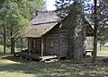
Nathaniel Parker Cabin
-
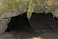
Cavern of the Skulls
-
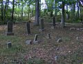
Belote Cemetery


