Bramfield facts for kids
Quick facts for kids Bramfield |
|
|---|---|
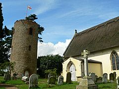
 St Andrew's Church, Bramfield |
|
| Population | 487 (2011) |
| Shire county | |
| Region | |
| Country | England |
| Sovereign state | United Kingdom |
| Post town | Halesworth |
| Postcode district | IP19 |
| EU Parliament | East of England |
Bramfield is a small village and civil parish in the eastern part of Suffolk, an English county. It is located in the East Suffolk district. The village is about 5 miles (8 km) south of the market town of Halesworth. It sits on the A144 road, which connects Halesworth to the A12 road, a major route through Suffolk.
Bramfield is also about 24 miles (39 km) north-east of Ipswich, which is the county town. It is 15 miles (24 km) south-west of the port of Lowestoft. The East Suffolk Line, a railway line between Lowestoft and Ipswich, runs close to the west of the village. The nearest train station is Halesworth railway station.
Contents
History of Bramfield
Bramfield grew up where several roads met, close to the start of a small river that flows into the River Blyth. The village is mentioned in the Domesday Book, a famous survey from 1086, where it was called Bufelda. It was a large village with 42 households.
In the Middle Ages, an important road connecting the port of Dunwich to Bury St Edmunds crossed the modern-day A144 road right in the middle of Bramfield. The village still has its original cross-shaped layout because it developed around these crossroads.
Archaeologists have found signs of human activity from the Bronze Age and Iron Age near Bramfield. Many medieval sites have also been discovered. One important site is a scheduled monument called Castle Yard, which is a circular earthwork about 83 metres (272 feet) across, located south-east of the village.
Bramfield used to have a market until the 16th century. The village's economy has always been based on farming. The linen industry, which grew in the Waveney valley to the north, also played a part. From the 18th century, making malt (for brewing) and milling grain were also important jobs. The village once had two windmills, but they were taken down in 1904 and 1944.
Geography of Bramfield
Bramfield is located near the beginning of a small river that flows into the River Blyth. The main street of the village follows this river valley. To the east of the parish, you can find an area of sandy soil called "sandlings." The village itself is on the eastern edge of a clay plateau known as "High Suffolk."
Life in Bramfield
Most of Bramfield has been named a conservation area since 1987. This means the local council works to protect the village's special character and history.
Bramfield has a few local services. These include Bramfield Primary School, a pub, a village hall, a garage, and a butcher's shop. However, some services have closed down since the 1980s. Besides the main church, the village also has a United Reformed chapel, which was built in 1841 and has its own graveyard.
A small village green can still be found in the centre of Bramfield, right outside the pub. The pub is called The Queen's Head. Parts of the pub building date back to the 16th century, and it is a Grade II listed building.
Bramfield House School is about 1 mile (1.6 km) west of the village, on the road to Walpole. It is a special residential school for boys aged 7 to 18 who have special educational needs.
Important Buildings
Bramfield has several buildings that are officially "listed." This means they are important for their history or architecture and are protected.
St Andrew's Church
The parish church of St Andrew was built in the 14th century. It has a very old, detached round tower from the 12th century. This church is special because it is the only one in Suffolk with a round tower that stands separately from the main church building. Both the church and its tower are Grade I listed buildings, which is the highest level of protection.
Bramfield Hall
Bramfield Hall is a large house that dates back to the 16th century. It was changed and made much bigger in the 18th century. The hall is built from red bricks and has three floors. It has a symmetrical front with nine sections and wings that stick out.
The wall around the estate is a special type called a crinkle crankle wall. It is built in a wavy line, which makes it stronger and more stable. Bramfield Hall itself is a Grade II* listed building.
Bramfield Hall was home to the Tatlock family for many years. Later, it was the home of Gladwyn Jebb, who became the 1st Baron Gladwyn of Bramfield. He was the acting Secretary-General of the United Nations when it was first formed in 1945. He is buried in St Andrew's church in the village.
 | Bessie Coleman |
 | Spann Watson |
 | Jill E. Brown |
 | Sherman W. White |


