Brule County, South Dakota facts for kids
Quick facts for kids
Brule County
|
|
|---|---|

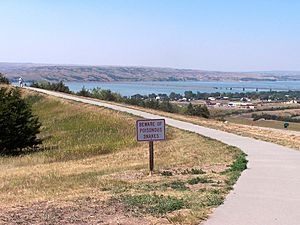
Chamberlain, South Dakota and the Missouri River
|
|

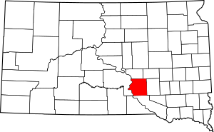
Location within the U.S. state of South Dakota
|
|
 South Dakota's location within the U.S. |
|
| Country | |
| State | |
| Founded | 1875 (created) 1879 (organized) |
| Named for | Brulé subtribe of Lakota people |
| Seat | Chamberlain |
| Largest city | Chamberlain |
| Area | |
| • Total | 846 sq mi (2,190 km2) |
| • Land | 817 sq mi (2,120 km2) |
| • Water | 29 sq mi (80 km2) 3.5% |
| Population
(2020)
|
|
| • Total | 5,247 |
| • Estimate
(2023)
|
5,311 |
| • Density | 6.202/sq mi (2.3947/km2) |
| Time zone | UTC−6 (Central) |
| • Summer (DST) | UTC−5 (CDT) |
| Congressional district | At-large |
Brule County is a county located in the state of South Dakota in the United States. In 2020, about 5,247 people lived there. The main town and county seat (where the county government is) is Chamberlain.
Contents
History
Brule County was first created on January 14, 1875. It was formed from a part of Charles Mix County. However, in May 1875, the US President Grant ordered that no one could settle in Brule County. This order was later canceled.
The county's government was fully set up in September 1879. On March 9, 1883, Brule County grew a little bit when some land from Buffalo County was added. The county got even bigger on June 4, 1891, when American Island in the Missouri River became part of it. The county's borders have stayed the same since then.
Geography
The Missouri River flows south along the western edge of Brule County. The land in the county has gentle, rolling hills. Some of this land is used for farming. The county covers a total area of about 846 square miles (2,191 square kilometers). Most of this, about 817 square miles (2,116 square kilometers), is land. The remaining 29 square miles (75 square kilometers) is water, which is about 3.5% of the total area.
Major roads
These are the main highways that go through Brule County:
Neighboring counties
Brule County shares its borders with these other counties:
- Buffalo County to the north
- Jerauld County to the northeast
- Aurora County to the east
- Charles Mix County to the south
- Lyman County to the west
Protected natural areas
Brule County has several areas set aside to protect wildlife and nature. These include:
- Boyer State Game Production Area
- Brule Bottom State Game Production Area
- Burning Brule State Game Production Area
- Chain lake State Game Production Area
- Chamberlain State Game Production Area
- Elm Creek State Game Production Area
- Elm Creek State Lakeside Use Area
- Hoover State Game Production Area
- Kimball State Game Production Area
- Lake Sixteen State Game Production Area
Lakes
- Lake Francis Case (part of this large lake is in Brule County)
- Red Lake
Population
| Historical population | |||
|---|---|---|---|
| Census | Pop. | %± | |
| 1880 | 238 | — | |
| 1890 | 6,737 | 2,730.7% | |
| 1900 | 5,401 | −19.8% | |
| 1910 | 6,451 | 19.4% | |
| 1920 | 7,141 | 10.7% | |
| 1930 | 7,416 | 3.9% | |
| 1940 | 6,195 | −16.5% | |
| 1950 | 6,076 | −1.9% | |
| 1960 | 6,319 | 4.0% | |
| 1970 | 5,870 | −7.1% | |
| 1980 | 5,245 | −10.6% | |
| 1990 | 5,485 | 4.6% | |
| 2000 | 5,364 | −2.2% | |
| 2010 | 5,255 | −2.0% | |
| 2020 | 5,247 | −0.2% | |
| 2023 (est.) | 5,311 | 1.1% | |
| U.S. Decennial Census 1790–1960 1900–1990 1990–2000 2010–2020 |
|||
2020 population count
According to the 2020 census, Brule County had 5,247 people. There were 2,024 households and 1,271 families living in the county. On average, there were about 6.4 people per square mile.
2010 population count
In the 2010 census, there were 5,255 people living in Brule County. Most people (88.4%) were white. About 8.5% were Native American. People of Hispanic or Latino origin made up 1.4% of the population. The average age of people in the county was 41.3 years old.
Communities
These are the different types of communities you can find in Brule County:
Cities
- Chamberlain (This is the county seat)
- Kimball
Town
Census-designated places
These are areas that are like towns but are not officially incorporated as cities or towns:
- Bijou Hills
- Cedar Grove Colony
- Grass Ranch Colony
- Ola
Unincorporated community
- Grandview
Townships
Townships are smaller local government areas within the county:
- America
- Brule
- Chamberlain
- Cleveland
- Eagle
- Highland
- Kimball
- Lyon
- Ola
- Plainfield
- Pleasant Grove
- Plummer
- Pukwana
- Red Lake
- Richland
- Smith
- Torrey Lake
- Waldro
- West Point
- Wilbur
- Willow Lake
- Union
See also
 In Spanish: Condado de Brule para niños

