Brush Creek (Sonoma County, California) facts for kids
Quick facts for kids Brush Creek |
|
|---|---|

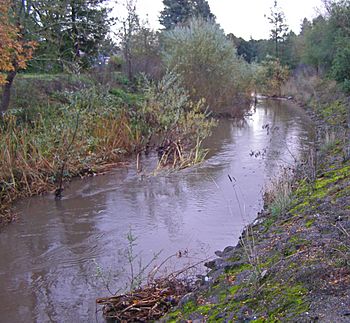
Brush Creek looking south toward the Highway 12 bridge.
|
|
|
Location of the mouth in California
|
|
| Other name(s) | Rincon Creek |
| Country | United States |
| State | California |
| Region | Sonoma County |
| City | Santa Rosa, California |
| Physical characteristics | |
| Main source | north of Santa Rosa, California 577 ft (176 m) 38°30′34″N 122°41′48″W / 38.50944°N 122.69667°W |
| River mouth | Santa Rosa Creek Santa Rosa, California 210 ft (64 m) 38°27′9″N 122°40′40″W / 38.45250°N 122.67778°W |
Brush Creek is a small stream in Sonoma County, California. It is also sometimes called Rincon Creek. This creek flows into Santa Rosa Creek.
Brush Creek starts in the southern part of the Mayacamas Mountains. These mountains are located in Sonoma County. The lower part of the creek flows through a neighborhood in Santa Rosa.
During the 1990s, this part of Brush Creek was cleaned up. This project was supported by the U.S. Environmental Protection Agency. The goal was to help steelhead fish travel and lay their eggs (this is called spawning). More cleanup work and plans to make it part of city parks are still happening.
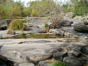
The spot where Brush Creek meets Santa Rosa Creek is very special. Long ago, it was a village for the Pomo people. It also has cool, flat boulders in the stream, which are a natural wonder.
Brush Creek is about three miles long. It drains water from an area called Rincon Valley in northern Santa Rosa. It also drains water from nearby areas that are not part of the city. Old maps show this stream as Rincon Creek. Today, Rincon Creek is a smaller stream that flows into Brush Creek. This happens about four kilometers upstream from where Brush Creek ends. So, Rincon Creek is like the west branch of the upper Brush Creek.
Where Does Brush Creek Flow?
The Lower Part of Brush Creek
The "Flat Rocks" are a cool feature where Brush Creek meets Santa Rosa Creek. This spot was important for the Pomo people long ago. Today, it's a nice place for hikers to enjoy nature.
Right above where the creeks meet, the channel was changed. This was done to make space for houses. The stream banks were made steeper than they naturally would be. But there are still many plants growing along the banks. These include Arroyo willow trees and Broad-leaf cattail plants. Some native trees like Coast live oak and Garry oak also grow here.
During late summer, the water flow is very low. It's only about 50 to 100 liters per second. But after the first big rain of autumn, the water flow increases a lot. It can reach about 120 cubic feet (3.4 cubic meters) per second. The willows and cattails help slow down the water. This stops the creek from flowing too fast. The sides of the creek are partly covered with asphalt. This helps keep the banks stable and stops them from wearing away. In this part of Brush Creek, Ducker Creek joins from the east. Another branch of Brush Creek also joins from the west.
The soil in the creek bed is called "riverwash." This means it's made of new gravel and silt. These materials were brought in by the stream from higher up. This layering of soils and gravels forms the creek bed.
The Upper Part of Brush Creek

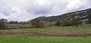
The upper part of Brush Creek is mostly outside the city of Santa Rosa. In these areas, the creek hasn't been changed much by people. Some houses along Anderson Drive are built close to the creek. But there aren't many flood control changes here. There is a small reservoir (a human-made lake) on Middle Fork Brush Creek. This reservoir was built near Saddle Creek Drive. Above Badger Road, there is a dam across Brush Creek. This dam creates the small reservoir.
The water that feeds the reservoir comes from two branches of Brush Creek. It's hard for people to visit the creek or the reservoir in this upper area. There are fewer cattail plants here. Instead, you can see more mature Garry oaks and Valley oak trees. Above Baird, the land changes. It becomes mostly grazing land for farm animals. This area is in the lower foothills of the western Mayacmas Mountains.
 | Laphonza Butler |
 | Daisy Bates |
 | Elizabeth Piper Ensley |


