Bryden, Queensland facts for kids
Quick facts for kids BrydenQueensland |
|||||||||||||||
|---|---|---|---|---|---|---|---|---|---|---|---|---|---|---|---|

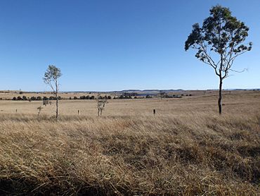
Paddocks along Corcorans Road, 2015
|
|||||||||||||||
| Population | 22 (2021 census) | ||||||||||||||
| • Density | 0.278/km2 (0.72/sq mi) | ||||||||||||||
| Postcode(s) | 4312 | ||||||||||||||
| Area | 79.0 km2 (30.5 sq mi) | ||||||||||||||
| Time zone | AEST (UTC+10:00) | ||||||||||||||
| Location |
|
||||||||||||||
| LGA(s) | Somerset Region | ||||||||||||||
| State electorate(s) | Nanango | ||||||||||||||
| Federal Division(s) | Blair | ||||||||||||||
|
|||||||||||||||
Bryden is a small, quiet rural area in Queensland, Australia. It's part of the Somerset Region. In 2021, only 22 people lived there, making it a very small community!
Contents
Exploring Bryden's Landscape
The eastern part of Bryden is mostly untouched bushland. It sits on the western side of the D'Aguilar Range, which is a long chain of hills.
Bryden's Past: A Look Back
The name Bryden comes from the very first person who settled in this area. Before it was called Bryden, the area was known as Deep Creek.
Old Schools in Bryden
Imagine going to school in a bark hut! That's how Mount Brisbane Provisional School started on April 17, 1876. A kind person named Mr. Carl Blank built it for free. There were 26 students and one teacher, Mr. Goodwin.
In 1879, it became Mount Brisbane State School. Then, in 1893, its name changed to Deep Creek State School. Finally, in 1930, it was renamed Bryden State School.
Sometimes, there weren't enough students, so the school had to close temporarily. Teachers were even shared with another school called Dundas State School. In 1936, all teaching stopped.
But the school reopened on April 14, 1947, as Bryden Provisional School. It closed for good on May 13, 1963. The school was located on Loughrans Road.
St Anne's Catholic Church
On August 19, 1900, people gathered to lay the first stone for a new Catholic church. It was officially opened on February 17, 1901, and named St Anne's Catholic Church.
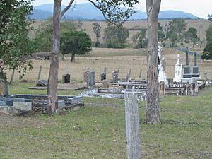
The church had a cemetery behind it. It was located on Wivenhoe Somerset Road, near Corcorans Road. The church building is no longer there, but the cemetery still remains.
Bryden Hall: A Community Place
The original Bryden Hall sadly burned down on December 18, 1927. But the community quickly built a new one!
The new Bryden Hall officially opened on September 1, 1928. It was a place for everyone to gather. In 1980, the hall was moved to the Esk Showgrounds, where it still stands today.
Who Lives in Bryden?
In 2011, Bryden's population was counted along with a nearby area called Crossdale. Together, they had 190 people.
Later, in 2016, Bryden had 33 people living there. By 2021, the population was 22 people.
Special Places: Heritage Listings
Bryden has some special places that are protected because of their history. One of these is Castleholme Homestead, located along Bryden-Crossdale Road.
Learning and Education
There are no schools directly in Bryden. Students usually travel to nearby towns for their education.
- For primary school, kids might go to Fernvale State School in Fernvale or Toogoolawah State School in Toogoolawah.
- For high school, students can attend Lowood State High School in Lowood or Toogoolawah State High School in Toogoolawah.
Local Facilities
Bryden has a Catholic cemetery. It is located at 2479 Wivenhoe Somerset Road, right next to where the old Catholic Church used to be. It's also very close to the Castleholme Homestead.
 | Isaac Myers |
 | D. Hamilton Jackson |
 | A. Philip Randolph |


