Burlington Heights (Ontario) facts for kids
Quick facts for kids Burlington Heights |
|
|---|---|

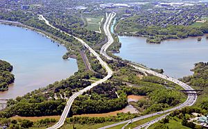
View of Burlington Heights from Burlington.
|
|
| Location | Hamilton, Ontario., Ontario, Canada |
| Elevation | 100 metres (330 ft) |
| Governing body | City of Hamilton |
| Owner | City of Hamilton |
| Lua error in Module:Location_map at line 420: attempt to index field 'wikibase' (a nil value). | |
Burlington Heights is a high piece of land in Hamilton, Ontario. It sits about 100 metres (330 ft) above the west end of Hamilton Harbour. This land continues north towards the city of Burlington, Ontario. It separates a marsh called Cootes Paradise from the harbour.
Burlington Heights was formed naturally from sand and gravel. It was created by an ancient lake called Glacial Lake Iroquois. This land is part of a longer bar that stretches south into Hamilton.
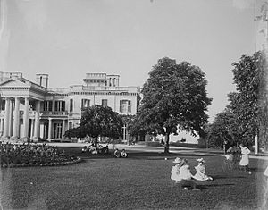
York Boulevard crosses Burlington Heights. On the south side, you'll find large park areas. Dundurn Castle is on the east side of the road. The big Hamilton Cemetery is on the west side. North of Dundurn Castle, there's a city park named after Sir John Harvey.
The southern part of Burlington Heights became a National Historic Site of Canada in 1929. This was because it was very important for the British military during the War of 1812. Later, Dundurn Castle also became a National Historic Site in 1984. The Royal Botanical Gardens is another National Historic Site right next to Burlington Heights. The Royal Botanical Gardens manages the land on the Burlington Heights peninsula north of the Desjardins Canal.
Contents
History of Burlington Heights
In the late 1700s, the Anishinaabe people used Burlington Heights a lot. These people, known as the Mississaugas, traveled along the northern shore of Lake Ontario. They moved throughout the year to find different resources.
The Reverend Peter Jones (Kahkewāquonāby) was born on Burlington Heights in 1802. He was an Anishinaabe farmer, missionary, and writer. His mother was Tuhbenahneequay, and his father was Augustus Jones, a United Empire Loyalist who surveyed land. These people are now known as the Mississaugas of the Credit First Nation.
The 1800s: A Time of Change
Burlington Heights and the War of 1812

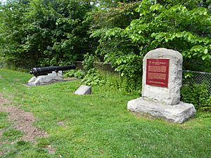
During the War of 1812, Burlington Heights was a key military post for the British Army. The British army set up their post in May 1813 on land they took from Richard Beasley.
They built defenses like batteries (for cannons), a place to store gunpowder, and earthworks. Soldiers from the 8th (The King's) and 49th (Princess Charlotte of Wales's) (Hertfordshire) Regiments were stationed here. They had to retreat to the Heights after American troops moved into the Niagara Peninsula.
From this post, British forces launched a successful surprise attack. This happened early on June 6, 1813, at Stoney Creek. The British, led by General John Vincent and Sir John Harvey, defeated a much larger American force.
On July 29, 1813, American ships arrived near Burlington Heights. They wanted to force the British out and help their own troops at Fort George. About 500 American soldiers landed at Burlington Beach. Their commander, Colonel Winfield Scott, saw that the British were too well-defended on the Heights. So, the American force left the area. Instead, they decided to raid the settlement of York (which is now Toronto).
Because of its importance in the War of 1812, the southern part of Burlington Heights was named a National Historic Site of Canada in 1929.
After the War of 1812
After the War of 1812, old British army buildings on the northern part of the peninsula were used as a hospital. This hospital helped immigrants who had contagious diseases. It was especially busy during a serious outbreak of cholera between 1832 and 1833.
In 1832, Richard Beasley sold his land on the Heights to Sir Allan Napier MacNab. Sir Allan then built the large 72-room Dundurn Castle on the same spot where Beasley's house once stood.

Before 1852, the Heights separated Cootes Paradise Marsh from Hamilton Harbour. That year, the Desjardins Canal was straightened. This canal had opened in 1836, allowing ships to travel from Hamilton Harbour to Dundas. The straightening involved digging through Burlington Heights.
On March 12, 1857, a terrible event happened known as the Desjardins Canal disaster. A Great Western Railway bridge over the Desjardins Canal collapsed. This happened because a train derailed due to a broken axle. Fifty-nine people lost their lives. This remains one of Canada's worst railway accidents.
The 1900s: Parks and Gardens
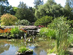
In 1926, the City of Hamilton bought most of Burlington Heights north of the Desjardins Canal. They planned a city improvement project and a new bridge over the canal. This project was called the "Northwestern Entrance to Hamilton" and took place from 1927 to 1932. The beautiful gardens created were later included in the Royal Botanical Gardens in 1932.

The southern part of Burlington Heights was named a National Historic Site of Canada in 1929. This was due to its important military role for the British during the War of 1812. Other places on the Heights also became National Historic Sites. Dundurn Castle, for example, was recognized in 1984 for its amazing architecture and how well its original design has been kept.
The northern part of Burlington Heights became part of the Royal Botanical Gardens National Historic Site of Canada in 1993. This area includes important gardens that started in the 1930s as part of the City Beautiful movement. These gardens were influenced by the work of Thomas Baker McQuesten.
 | James Van Der Zee |
 | Alma Thomas |
 | Ellis Wilson |
 | Margaret Taylor-Burroughs |

