Cache River (Illinois) facts for kids
Quick facts for kids Cache River |
|
|---|---|
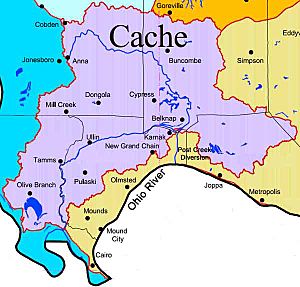
Cache River Watershed Map
|
|
| Country | United States |
| State | Illinois |
| Physical characteristics | |
| Main source | Anna, Union County, Illinois 37°27′00″N 89°14′44″W / 37.45000°N 89.24556°W |
| River mouth | Ohio River South of Mound City, Alexander County, Illinois 37°04′01″N 89°10′22″W / 37.06694°N 89.17278°W |
| Length | 92 mi (148 km) |
| Basin features | |
| Protection status | |
| Official name: Cache River and Cypress Creek Wetlands | |
| Designated: | 1 November 1994 |
| Reference #: | 711 |
| Designated: | 1972 (Heron Pond); 1980 (Lower Cache) |
The Cache River is a 92-mile-long (148 km) waterway in southern Illinois. This area is sometimes called Little Egypt. The river's basin covers 737 square miles (1,909 km²) across six counties. These are Alexander, Johnson, Massac, Pope, Pulaski, and Union.
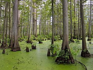
The Cache River is part of the largest group of wetlands in Illinois. These wetlands are America's northernmost cypress/tupelo swamp. They are home to 91 percent of Illinois' best swamp and wetland areas. More than 100 species of plants and animals that are threatened or endangered in Illinois live here. In 1996, the Cache River was named a Wetland of International Importance. This was done by the Ramsar Convention, an international agreement.
A large part of the Cache River Wetlands is protected. The U.S. Fish and Wildlife Service and the Illinois Department of Natural Resources help protect it. The Cypress Creek National Wildlife Refuge was started in 1990. It covers 15,000 acres (61 km²) of water and riverbank habitats. It is planned to grow to 35,500 acres (144 km²). The Cache River State Natural Area protects another 14,489 acres (58.63 km²). Local landowners also protect 13,500 acres (55 km²) of restored wetlands. They do this through the Wetlands Reserve Program. This program works with the Natural Resources Conservation Service (NRCS). Many landowners also use other conservation methods. These include special farming and planting trees. In total, over 45,000 acres (180 km²) of private land in the Cache River Watershed use NRCS conservation programs.
The Lower Cache River is a habitat that includes many of these protected lands. It has been named a U.S. National Natural Landmark. The Heron Pond – Little Black Slough Nature Preserve is another National Natural Landmark. It is located in the upper part of the Cache River.
History of the Cache River Area
The Cache River area was an important trading spot for Native Americans. There are several old archeological sites here. One is the Cypress Citadel site, south of Cypress, Illinois.
French explorers called the river Cache. This means "secret" or "hidden place." American settlers arrived in 1803. They found the land too wet for farming. The swamps also had many mosquitoes and snakes. Many early settlers got sick with malaria. The Cache River was great for hunting and fishing. It also had lots of timber.
From about 1810 to 1890, cutting timber became a big business. Cypress wood was popular because it was light and resisted water. Small towns near the swamp grew during this time. Sawmills and small factories opened to process timber. They made lumber, railroad ties, and charcoal.
How the River Was Changed
After most of the trees were cut, people started farming. They began to drain and change the river. The landscape changed a lot. This was mainly because a new channel was dug. It connected the Cache River to the nearby Ohio River. This channel, called the Post Creek Cutoff, was built from 1912 to 1915.
The Post Creek Cutoff split the Cache River into two parts. The Upper Cache now flows into the Ohio River. The Lower Cache still flows to its original outlet on the Mississippi River. In 1952, the Karnak levee was built. This made the split between the two rivers even stronger.
In 1950, another channel was made. It connected the Cache and Mississippi rivers. This was about 11 miles (18 km) north of the Cache's natural mouth at the Ohio River. The last 11 miles (18 km) of the Cache still flow into the Ohio River.
In 2002, the levee between the Post Creek Cutoff and the Lower Cache broke. This happened during a spring flood. The broken levee caused water levels in the Lower Cache to drop. Sometimes, when the water is high, the Lower Cache flows backward. It flows east to the diversion channel. When the water level drops, it flows west to the Mississippi. The broken levee also means this part of the Cache is more likely to flood.
The future of the levee is not clear. The U.S. Army Corps of Engineers no longer helps with it. This means it cannot get money from the government. A group called the Cache River Wetlands Joint Venture Partnership is thinking about fixing the levee. This group includes Ducks Unlimited, Illinois Department of Natural Resources, Natural Resources Conservation Service, The Nature Conservancy, and U.S. Fish and Wildlife Service. They want to restore the river's natural flow.
Protecting the Cache River
Since the mid-1980s, people have worked to restore the Cache River. They want it to be more like it was in the past. A group of local people, called the Citizens Committee to Save the Cache River, started this effort. They got help from state and federal agencies. They also worked with non-profit groups like The Nature Conservancy. Together, they formed the Cache River Wetlands Joint Venture Partnership.
For the past fifteen years, they have worked to:
- Control erosion (when soil washes away).
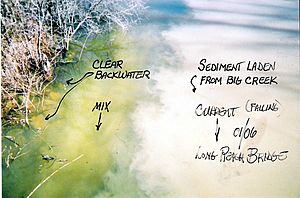
- Reduce siltation (when mud and dirt build up).
- Keep water levels stable.
- Restore habitats for game animals.
- Provide fun activities for the public.
One main goal is to reconnect the Upper and Lower Cache rivers.
During this restoration work, there have been some disagreements. Some local farmers worried that restoring the wetlands would cause flooding. They also feared losing their farmland. Some local hunters and fishers worried their favorite spots would be closed. State and Federal agencies have tried to work with everyone. But some disagreements still remain.
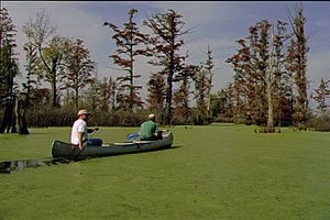
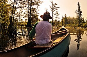
The Cache River offers many fun things to do. You can go canoeing, hiking, or bird watching. Fishing and hunting are also popular. The Henry N. Barkhausen Cache River Wetlands Center teaches about the river's history and nature. This center is also the start of the 47.5-mile (76.4 km) Tunnel Hill State Trail. This trail is great for biking. It follows an old railroad line. You can see swamps and forests along the way. The wetland center also has information about places to hike, canoe, fish, hunt, or watch birds.
The Friends of the Cache River Watershed is an organization that helps protect the river. They focus on teaching people about the environment. They also work on protecting natural resources. This group helps different people come together. These include farmers, teachers, tourists, and government agencies. All of them care about the environment and protecting nature.
 | Valerie Thomas |
 | Frederick McKinley Jones |
 | George Edward Alcorn Jr. |
 | Thomas Mensah |


