
Cadet Peak facts for kids
Quick facts for kids Cadet Peak |
|
|---|---|
.jpg)
Cadet Peak seen from Goat Lake
|
|
| Highest point | |
| Elevation | 7,186 ft (2,190 m) |
| Prominence | 706 ft (215 m) |
| Isolation | 1.59 mi (2.56 km) |
| Parent peak | Kyes Peak |
| Geography | |

Cadet Peak
Location in Washington (state)

Cadet Peak
Location in the United States
|
|
| Location | Snohomish County, Washington, U.S. |
| Parent range | Cascade Range |
| Topo map | USGS Blanca Lake |
| Type of rock | Breccia |
| Climbing | |
| Easiest route | Scrambling |
Cadet Peak is a mountain in Washington state. It stands 7,186 feet (2,190 meters) tall. The peak is found in Snohomish County, near the western edge of the North Cascades.
It's located southeast of Barlow Pass along the Mountain Loop Highway. The historic Monte Cristo area is just two miles east. Cadet Peak is part of the Henry M. Jackson Wilderness. It is managed by the Mount Baker-Snoqualmie National Forest.
The mountain was first called Foggy Peak. This was because of the Foggy Mine claim on its north side. But in 1896, its name changed to Cadet Peak. The name Foggy Peak then moved to a different mountain nearby. In the old mining days, the long mountain range from Cadet Peak to Sheep Mountain was known as Pride of the Mountains Range. Kyes Peak is Cadet's closest taller neighbor, about 1.59 miles (2.56 km) to the south-southeast. Rain and melting snow from the mountain flow into streams that join the Sauk River.
Mountain Weather
Cadet Peak is in a "marine west coast" climate zone. This means it gets a lot of moisture from the nearby Pacific Ocean. Most weather systems start over the Pacific Ocean. They then move northeast towards the Cascade Mountains.
When these weather systems hit the tall Cascade Mountains, they are forced to rise. As they rise, they cool down and drop their moisture. This causes a lot of rain or snow to fall on the mountains. This process is called orographic lift.
The west side of the North Cascades gets a lot of precipitation. This is especially true in winter, when most of it falls as snow. Because of the ocean's influence, the snow is often wet and heavy. This can lead to a high risk of avalanches.
During winter, the weather is usually cloudy. But in summer, high pressure systems over the Pacific Ocean often bring clear skies. Due to its mild climate and closeness to the ocean, temperatures rarely go below 0°F (-18°C) or above 80°F (27°C). The best time to visit or climb Cadet Peak is from July through September. This is when the weather is usually most pleasant.
How the Mountains Formed
The North Cascades have very rugged land. You can see jagged peaks, long ridges, and deep valleys carved by glaciers. These amazing shapes were created by geological events millions of years ago. These events caused big changes in elevation. This led to different climates and types of plants in the area.

The Cascade Mountains began forming millions of years ago. This was during the late Eocene Epoch. The North American Plate was slowly moving over the Pacific Plate. This caused many volcanic eruptions. Also, small pieces of the Earth's crust, called terranes, came together. This helped create the North Cascades about 50 million years ago.
During the Pleistocene period, over two million years ago, glaciers moved across the land many times. As they moved, they scraped away rock and left behind debris. The "U"-shaped valleys you see today were formed by these glaciers. The main forces that created the tall peaks and deep valleys of the North Cascades are uplift (when land rises) and faulting (when cracks form in the Earth's crust), along with glaciation.
Images for kids
-
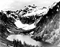
Goat Lake, Cadet Peak, ca 1920
-
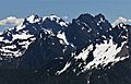
Cadet Peak (left) and Gemini Peaks (right) seen from Dickerman Mountain
.jpeg)

