
Cairo, Illinois facts for kids
Quick facts for kids
Cairo
|
||
|---|---|---|

Washington Avenue in Cairo, Illinois
|
||
|
||
| Etymology: Cairo, Egypt | ||
 |
||
.svg)
Location of Illinois in the United States
|
||
| Country | United States | |
| State | Illinois | |
| County | Alexander | |
| Area | ||
| • Total | 9.11 sq mi (23.59 km2) | |
| • Land | 6.99 sq mi (18.10 km2) | |
| • Water | 2.12 sq mi (5.49 km2) | |
| Elevation | 315 ft (96 m) | |
| Population
(2020)
|
||
| • Total | 1,733 | |
| • Density | 248.03/sq mi (95.77/km2) | |
| Time zone | UTC−6 (CST) | |
| • Summer (DST) | UTC−5 (CDT) | |
| ZIP Code |
62914
|
|
| Area code(s) | 618 | |
| FIPS code | 17-10383 | |
| GNIS feature ID | 2393491 | |
| Wikimedia Commons | Cairo, Illinois | |

Cairo (pronounced KAIR-oh) is a city located at the very southern tip of Illinois. It is the main city of Alexander County. Cairo is special because it sits where two huge rivers, the Ohio and Mississippi, meet. It's also the lowest point in Illinois and is completely surrounded by giant walls called levees to protect it from floods.
The city is named after Egypt's capital on the Nile River. This is why the area of Southern Illinois where Cairo is located is often called "Little Egypt."
Cairo became important in the 1830s and grew with busy river boat traffic. During the Civil War in 1862, Union General Ulysses S. Grant used Cairo as a key base. This helped him control the rivers and launch successful military campaigns.
Over time, transportation changed, and Cairo became less important as a river port. Its population, which was over 15,000 in 1920, has since dropped to 1,733 by 2020. Even with these changes, several historic buildings in Cairo are listed on the National Register of Historic Places.
In 2011, the entire city had to be evacuated because of major floods on the Mississippi River. The water levels were even higher than during the big flood of 1937. To save Cairo, engineers had to break levees in another area to lower the water.
Contents
History of Cairo: A River City's Journey
Early Days and Challenges
The first plans for Cairo as a city and a bank were made in 1818. However, no one actually settled there at that time. A serious attempt to build the town happened in 1836-37. A large levee was built around the area to protect it. But this plan failed by 1840, and only a few settlers stayed.
In 1842, a famous writer named Charles Dickens visited Cairo. He was not impressed and later used the city as an example of a terrible place in his book Martin Chuzzlewit.
Things changed in 1846 when a group of investors bought land in Cairo. They wanted it to be the end point for the new Illinois Central Railroad. The railroad finally arrived in 1855. A new city plan was created in 1857, and Cairo began to grow quickly. By 1860, more than 2,000 people lived there.
Cairo During the Civil War
In January 1862, during the Civil War, General Ulysses S. Grant took control of Cairo. He and Admiral Andrew Hull Foote made the city their main base. Cairo became a very important place for supplying troops and training soldiers for the rest of the war.
Because of the military's presence, much of Cairo's trade moved to Chicago. Cairo never fully got this trade back after the war. Instead, farming, logging, and sawmills became the main parts of the economy.
Growth After the War
Cairo's important location during the Civil War helped it become successful afterward. Several banks started during the war, and banking and steamboat traffic kept growing. Cairo was already a key steamboat port, and in 1854, it was officially named a "port of delivery" by the government.
Important Buildings and Flood Protection
In 1869, construction began on the United States Custom House and Post Office. This building was finished in 1872. It served as a place for customs, a post office, and a court. Today, it has been turned into a museum and is listed on the National Register of Historic Places.
After the Civil War, Cairo also became a major center for shipping goods by train. By 1900, many railroad lines connected through Cairo. The city also had a big ferry business, moving trains and cars across the rivers. This created many jobs.
Wealthy business owners built beautiful homes in Cairo during this time. These include the Magnolia Manor and the Riverlore Mansion. The Cairo Public Library, built in 1883, was also a gift to the city from Anna E. Safford. These buildings are also listed on the National Register.
Because Cairo is so low, it is completely surrounded by levees and flood walls to protect it from floods. In 1914, a huge flood gate called the "Big Subway Gate" was built. This gate weighs 80 tons and can seal off the city from floodwaters.
After the Great Mississippi Flood of 1927, the levee system around Cairo was made even stronger. In 1937, the Ohio River reached a record high level. To protect Cairo, engineers opened a levee in another area to relieve pressure on Cairo's flood wall. The concrete flood wall was then made even taller.
Economic Challenges and Changes
Cairo's economy started to slow down in the early 1900s. In 1889, the Illinois Central Railroad bridge was built over the Ohio River. This meant fewer ferries were needed. Then, in 1905, a second bridge was built across the Mississippi River at Thebes, Illinois. This bridge further reduced train traffic through Cairo. As steamboats were replaced by barges, river traffic also stopped less often in Cairo.
In 1929, the Cairo Mississippi River Bridge was finished, connecting Missouri and Illinois south of Cairo. The Cairo Ohio River Bridge was completed in 1937. With these two bridges, ferries were no longer needed. Also, both bridges allowed drivers to bypass Cairo completely. Even though the city was protected from the 1937 flood, its economic decline continued.
Racial Tensions and Further Decline
As river and rail traffic decreased, many jobs in Cairo disappeared. From the 1930s to the 1960s, Cairo's population stayed about the same. However, job opportunities were shrinking. The city had a history of racial problems, and tensions grew again in the late 1960s during the Civil Rights Movement. This made the city's economic problems even worse.
In July 1967, protests started in Cairo's Black community. Stores and a warehouse were burned, and windows were broken. The National Guard was called in. Black community leaders demanded new jobs, recreation programs, and an end to police unfairness.
In response, a group of white citizens formed the "White Hats" to help keep order. However, accusations of bullying by the White Hats against the Black community grew. In 1969, civil rights activists formed the Cairo United Front. This group brought together local organizations to stand up to the White Hats. They demanded changes like a Black police chief and equal job opportunities in the city.
Racial tensions peaked in summer 1969. Protests led to violence, and the Illinois Governor had to send in the National Guard. The Cairo United Front also started a long-term boycott of white-owned businesses. Violence continued, with businesses being burned and shootings occurring. The police chief resigned, saying the city couldn't handle the "guerrilla warfare tactics."
In 1978, Cairo's economy suffered another blow when the Interstate 57 bridge opened across the Mississippi River. This interstate bypassed the city, hurting the remaining hotels and restaurants. Cairo's hospital also closed in 1986 due to debt and fewer patients.
Cairo Today
With the decline in river trade and other changes, Cairo has seen a big drop in its economy and population. Its highest population was over 15,000 in 1920, but by 2010, it had only 2,831 residents. The community is now working to save its historic buildings and attract visitors who are interested in its history and its connection to the Mississippi and Ohio Rivers.
The city still faces challenges like poverty, crime, and unemployment. A local clinic provides medical and dental care, as well as mental health services.
Geography of Cairo

Cairo is located where the Mississippi and Ohio rivers meet. It is near Mounds, Illinois. The city's elevation is 315 feet (96 meters) above sea level. The lowest point in the state of Illinois is actually on the Mississippi River in Cairo.
Cairo covers about 9.086 square miles (23.59 square kilometers). Most of this area, about 6.97 square miles (18.10 square kilometers), is land. The rest, about 2.116 square miles (5.49 square kilometers), is water.
Cairo's Climate
Cairo has a humid subtropical climate. This means it has hot and humid summers. In July, the average daily temperature is about 78.9°F (26.1°C). Temperatures often reach 90°F (32°C) or higher. Winters are generally cool but can have mild periods. The average temperature in January is about 34.0°F (1.1°C).
Cairo gets a good amount of rain throughout the year. Because it's low and near the big rivers, strong cold temperatures are rare in winter. However, in summer, the same features keep heat and humidity trapped, making it feel very muggy.
| Climate data for Cairo, Illinois | |||||||||||||
|---|---|---|---|---|---|---|---|---|---|---|---|---|---|
| Month | Jan | Feb | Mar | Apr | May | Jun | Jul | Aug | Sep | Oct | Nov | Dec | Year |
| Record high °F (°C) | 75 (24) |
77 (25) |
85 (29) |
94 (34) |
98 (37) |
106 (41) |
108 (42) |
103 (39) |
103 (39) |
92 (33) |
82 (28) |
79 (26) |
108 (42) |
| Mean daily maximum °F (°C) | 42.7 (5.9) |
47.9 (8.8) |
58.5 (14.7) |
69.6 (20.9) |
78.1 (25.6) |
86.2 (30.1) |
89.0 (31.7) |
88.1 (31.2) |
81.3 (27.4) |
70.3 (21.3) |
57.9 (14.4) |
45.6 (7.6) |
67.9 (19.9) |
| Mean daily minimum °F (°C) | 25.2 (−3.8) |
29.1 (−1.6) |
36.9 (2.7) |
46.4 (8.0) |
56.9 (13.8) |
65.1 (18.4) |
68.8 (20.4) |
67.0 (19.4) |
58.6 (14.8) |
47.2 (8.4) |
38.3 (3.5) |
28.9 (−1.7) |
47.4 (8.6) |
| Record low °F (°C) | −12 (−24) |
−5 (−21) |
6 (−14) |
25 (−4) |
36 (2) |
45 (7) |
56 (13) |
50 (10) |
39 (4) |
27 (−3) |
5 (−15) |
−9 (−23) |
−12 (−24) |
| Average precipitation inches (mm) | 3.69 (94) |
3.77 (96) |
4.05 (103) |
4.63 (118) |
5.27 (134) |
3.91 (99) |
4.14 (105) |
3.01 (76) |
3.19 (81) |
4.05 (103) |
4.46 (113) |
4.47 (114) |
48.64 (1,236) |
| Average snowfall inches (cm) | 3.1 (7.9) |
2.4 (6.1) |
1.6 (4.1) |
0 (0) |
0 (0) |
0 (0) |
0 (0) |
0 (0) |
0 (0) |
0 (0) |
0.3 (0.76) |
1.1 (2.8) |
8.6 (22) |
| Average precipitation days (≥ 0.01 in) | 8.3 | 9.5 | 9.8 | 10.8 | 10.6 | 9.1 | 7.9 | 6.9 | 6.4 | 7.9 | 9.1 | 10.1 | 106.4 |
| Mean monthly sunshine hours | 144.4 | 150.5 | 198.0 | 238.8 | 277.8 | 307.4 | 318.9 | 300.8 | 242.4 | 216.9 | 139.3 | 125.4 | 2,660.6 |
| Percent possible sunshine | 47 | 50 | 53 | 60 | 63 | 70 | 71 | 72 | 65 | 62 | 46 | 42 | 58 |
| Source 1: NOAA (1981–2010 temperature and precipitation normals, sun 1961–1987) | |||||||||||||
| Source 2: Western Regional Climate Center (snow normals 1948–2012), The Weather Channel (extremes) | |||||||||||||
Who Lives in Cairo? Demographics
| Historical population | |||
|---|---|---|---|
| Census | Pop. | %± | |
| 1850 | 242 | — | |
| 1860 | 2,188 | 804.1% | |
| 1870 | 6,267 | 186.4% | |
| 1880 | 9,011 | 43.8% | |
| 1890 | 10,324 | 14.6% | |
| 1900 | 12,566 | 21.7% | |
| 1910 | 14,548 | 15.8% | |
| 1920 | 15,203 | 4.5% | |
| 1930 | 13,532 | −11.0% | |
| 1940 | 14,407 | 6.5% | |
| 1950 | 12,123 | −15.9% | |
| 1960 | 9,348 | −22.9% | |
| 1970 | 6,277 | −32.9% | |
| 1980 | 5,931 | −5.5% | |
| 1990 | 4,846 | −18.3% | |
| 2000 | 3,632 | −25.1% | |
| 2010 | 2,831 | −22.1% | |
| 2020 | 1,733 | −38.8% | |
| Decennial US Census | |||
2020 Census Information
| Race | Number | Percentage |
|---|---|---|
| White (NH) | 434 | 25.04% |
| Black or African American (NH) | 1,193 | 68.84% |
| Native American or Alaska Native (NH) | 5 | 0.29% |
| Some Other Race (NH) | 5 | 0.29% |
| Mixed/Multi-Racial (NH) | 76 | 4.39% |
| Hispanic or Latino | 20 | 1.15% |
| Total | 1,733 |
In 2020, there were 1,733 people living in Cairo. There were 813 households and 434 families.
2010 Census Information
In 2010, Cairo had 2,831 people. About 69.6% were Black or African American, and 27.9% were White.
There were 1,268 households. About 26.7% of these had children under 18. The average household had 2.15 people. The average family had 3.00 people.
The median age in Cairo was 36.9 years old. The median income for a household was $16,682. About 44.2% of the population lived below the poverty line. This included 71.7% of those under 18.
Education in Cairo
Cairo is served by the Cairo Community Unit School District 1. This school district has a very high percentage of children living in poverty, about 60.6%. This is one of the highest rates in the United States.
The district has one elementary school, Emerson Elementary School. Students in middle and high school go to Cairo Junior/Senior High School. Another elementary school, Bennett Elementary School, closed in 2010.
A college called Shawnee Community College opened an extension center in Cairo in January 2019.
Getting Around Cairo: Transportation

The train service called Amtrak used to stop in Cairo. However, it stopped serving Cairo on October 25, 1987. Now, the closest stops are in Carbondale, Illinois, and Fulton, Kentucky.
Major Roads and Highways
Several important highways pass near Cairo:
 I-57
I-57 US 62
US 62 US 60
US 60 US 51
US 51 IL 3
IL 3
Because Cairo is on a narrow piece of land between the Mississippi and Ohio rivers, some highways like US 60 and 62 briefly cross through Illinois. This makes it easier to connect Missouri and Kentucky.
Air Travel
The Cairo Regional Airport offers services for small planes. For regular flights, the closest airports are Barkley Regional Airport and Cape Girardeau Regional Airport. They are about 23 to 26 miles away.
Cool Places to Visit in Cairo: Landmarks and Points of Interest

Magnolia Manor is a beautiful red brick house built in 1869. It has 14 rooms and special double walls to keep out the dampness. Inside, you can see many original furnishings from the 1800s. It is now a museum that shows what life was like in the Victorian era. Magnolia Manor has been listed on the National Register of Historic Places since 1969.

Other interesting places to see in Cairo include:
- Fort Defiance Park: A historic site from the Civil War.
- Gem Theatre: An old theater.
- The Hewer: A public sculpture from 1902.
- Cairo Custom House & Post Office: A historic building that is now a museum.
- The Riverlore: Another historic mansion.
- A. B. Safford Memorial Library: A beautiful old library.
Sports in Cairo
Cairo has a history with sports, especially baseball and basketball.
- Cairo used to have its own minor-league baseball team. They were known by different names like the Egyptians and Dodgers. They played in a league called the Kentucky–Illinois–Tennessee League in various years.
- The St. Louis Cardinals, a famous baseball team, held their spring training in Cairo from 1943 to 1945. This was because of travel rules during World War II.
- Cairo is also known for its love of basketball. In 2017, the Cairo Pilots high school basketball team had a great season. They almost won their first state championship, finishing with 23 wins and 6 losses. This was very impressive because the school only had 97 students that year!
Famous People from Cairo
To learn about famous people who came from Cairo, you can visit the main article: List of people from Cairo, Illinois.
Images for kids
-
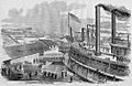
Embarkation of Union troops from Cairo on January 10, 1862
-
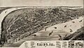
Cairo panoramic map, 1885.
-
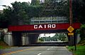
The Cairo Levee underpass
-
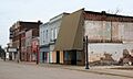
The mostly abandoned Historic Downtown Cairo.


See also
 In Spanish: Cairo (Illinois) para niños
