kids encyclopedia robot

Canton Viaduct facts for kids

Kids Encyclopedia Facts
Quick facts for kids
Canton Viaduct
Canton Viaduct.jpg
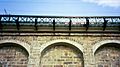
A west side view of the Canton Viaduct looking south with the former Paul Revere Copper Rolling Mill in the background, April 1977
Coordinates 42°09′32″N 71°09′14″W / 42.15889°N 71.15389°W / 42.15889; -71.15389
Carries 2 tracks (standard gauge) presently serving:
  • Amtrak's Northeast Corridor (intercity passenger)
  • MBTA's Providence/Stoughton Line (commuter)
  • CSX's Boston Subdivision (freight)
Crosses
  • Canton River (at Mill Pond)
  • Canton River Valley (Canton Dale)
  • Neponset Street
Locale Canton, Massachusetts
Other name(s)
  • The Great Wall of Canton
  • Canton's Great Wall
Maintained by Amtrak owned by the Massachusetts Bay Transportation Authority (MBTA)
Heritage status
Characteristics
Design Blind arcade cavity wall
Material
  • Walls - Granite
  • Deck - Reinforced concrete
Total length 615' (built on a one degree horizontal curve)
Width
  • 26'-28' foundations
  • 22'-24' walls; wider at the bottom than the top due to the 1":48" battre (sloped surface) on the exterior surface of walls
  • 30' deck; wider due to the cantilevered, precast, prestressed concrete deck
Height Varies due to valley contour, built with a stepped foundation.
  • 4' above ground level at southern end
  • 60' above river level
  • 70' maximum height (from foundation to coping)
Longest span 2 at 28' (granite/concrete deck arches over the granite roadway portal)
Number of spans 71 total:
  • 21 at 4' long (cavity ceiling slabs)
  • 6 at 6' long (river portals)
  • 1 at 18' long (concrete roadway portal added in 1953)
  • 1 at 22' long (granite roadway portal)
  • 40 at 24' long (granite/concrete deck arches)
  • 2 at 28' long (granite/concrete deck arches over the granite roadway portal)
Piers in water 7 (15 on land)
Load limit Unknown, currently carries Amtrak's 100-ton Acela Express up to 125 MPH
Clearance above Approximately 21' from top of rails to contact wires of the catenary system
Clearance below
  • 23' under the granite roadway portal
  • 18' under the concrete roadway portal
  • 6' under the six river portals
History
Designer William Gibbs McNeill, Chief Engineer for the Boston & Providence Railroad (B&P)
Construction begin April 20, 1834
Opened July 28, 1835
Statistics
Daily traffic
  • Trains passing over = 106 / day (November 2004) Freight traffic not included.
  • Motor vehicles passing under = 16,400 / day (2005 traffic study)
Canton Viaduct
Location Neponset and Walpole Sts., Canton, Massachusetts
Built 1834
NRHP reference No. 84002870
Added to NRHP September 20, 1984
Canton Viaduct map.svg
Canton River Valley at the intersection of Neponset St. and Walpole St.

Canton Viaduct is a blind arcade cavity wall railroad viaduct in Canton, Massachusetts, built in 1834–35 for the Boston and Providence Railroad (B&P).

At its completion, it was the longest (615 feet) and tallest (70 feet) railroad viaduct in the world; today, it is the last surviving viaduct of its kind. It has been in continuous service for 188 years; it now carries high-speed passenger and freight rail service.

The Canton Viaduct's walls are similar to the ancient curtain wall of Rhodes (built about 400 BCE) with rusticated stone. It supports a train deck about 60 feet (18 m) above the Canton River, the east branch (tributary) of the Neponset River. The stream pool passes through six semi-circular portals in the viaduct, flowing to a waterfall about 50 feet downstream.

The viaduct was the final link built for the B&P's then 41-mile mainline between Boston, Massachusetts; and Providence, Rhode Island. Today, the viaduct serves Amtrak's Northeast Corridor, as well as Massachusetts Bay Transportation Authority (MBTA) Providence/Stoughton Line commuter trains. It sits 0.3 miles (0.5 km) south of Canton Junction, at milepost 213.74, reckoned from Pennsylvania Station in New York City, and at the MBTA's milepost 15.35, reckoned from South Station in Boston.

Inception

Canton Viaduct Section
A partial isometric elevation of the Canton Viaduct with the deck removed; there are 21 cavities in the viaduct
Canton Viaduct Model-Deck Removed
Lego model of wall section with deck removed
Canton Viaduct Model-Deck and Dirt Removed
Lego model of wall section with deck removed and foundation exposed

The Canton Viaduct was erected in 1835 by the B&P, one of the first New England railroads, shortly after its 1831 founding. Thomas B. Wales, one of the original families of Boston, and owner of the T.B. Wales & Co. Shipping Company, was the first president of the B&P, The Taunton Branch Railroad, as well as the Western Railroad Corporation. Due to his friendship with prominent New England families, including the Revere family, they were able to bring the Canton Viaduct to fruition. The T.B. Wales & Co. clipper ships brought raw materials for manufacturing companies from its dock (Wales Wharf) and Counting House (Long Wharf) to various areas in New England. Without the influence of individuals such as Thomas B. Wales, Joseph Warren Revere, owner of the Revere Copper Company and major stockholders (most of whom were Board members), the Canton Viaduct would not have been built. There were better routes through other towns for the location of the railroad line from Boston to Providence. However, building the railroad through Canton placed the line close to Paul Revere's Copper Rolling Mill, where a half mile spur (using strap rails and horse power) connected the mill to Canton Junction and undoubtedly gave a boost to Revere's copper business. The other influencing factor that caused the Canton Viaduct to be built was a fatal accident in 1832 on the Granite Railroad, which used inclined planes to cross a valley. The original plans called for the use of inclined planes to cross the Canton River Valley (Canton Dale), but they were changed after the inclined plane accident, and a viaduct was built instead. This unique viaduct was designed by a U.S. Army Corps of Engineers Officer and West Point graduate - Captain William Gibbs McNeill. He was assisted by engineers, Major George Washington Whistler (McNeill's brother-in-law), Major General Isaac Ridgeway Trimble and General William Raymond Lee. McNeill and Whistler were the uncle and father of the artist James McNeill Whistler. The viaduct was built by the Dodd & Baldwin company from Pennsylvania; the firm was established by cousins Ira Dodd and Caleb Dodd Baldwin. Around this time, Russia was interested in building railroads. Tsar Nicholas I sent workmen to draw extensive diagrams of the Canton Viaduct. He later summoned Whistler to Russia as a consulting engineer to design the Moscow–Saint Petersburg Railway, on which two viaducts were modeled after the Canton Viaduct. A scale model viaduct of similar design is on display at the Oktyabrsky Railroad Museum in St. Petersburg.

Design and construction

Classification

This Canton Viaduct is the first and possibly only viaduct to use both a blind arcade and cavity wall structure. The structure is often referred to as a "multiple arch bridge", but it does not fit the classic definition of spanning a distance between two points. Although the deck arches appear to extend through to other side, they do not; each deck arch is only four feet deep. The deck arches support the spandrels, deck (beyond the walls), coping and parapets; they are not tied to the longitudinal walls. The only arches that extend through to the other side are six river portals and two roadway portals. The 'buttresses' are also unique in that they extend through to the other side, so they are actually transverse walls. Due to its use of double walls and lack of open arches, the Canton Viaduct is more accurately described as a blind arcade cavity wall. The Thomas Viaduct (Maryland, 1835) and Starrucca Viaduct (Pennsylvania, 1847) are classic examples of multiple arch viaducts, as their primary support system consists of open semi-circular arches spanning the distance between piers, without any walls.

Materials

The Canton Viaduct contained 14,483 cubic feet (15,800 perches) of granite, which weighs approximately 66,000,000 pounds (33,000 short tons) prior to its concrete redecking in 1993. Each stone has a Mason's mark to identify who cut the stone. Each course is 22" - 24" high and laid in a pattern closely resembling a Flemish bond. Exterior stone for the walls, wing wall abutments, portals, deck arches, coping, parapets and the foundation stone are riebeckite granite mined from Moyles quarry (a.k.a. Canton Viaduct Quarry) located on the westerly slope of Rattlesnake Hill in Sharon, Massachusetts; now part of Borderland State Park. This type of granite was chosen because it does not stain as it weathers, but retains its original color. Interior stone for the foundation, walls, wing wall abutments, binders, stiles, deck, Dedication Stone and capstone are of a different type of granite mined from Dunbar's quarry in Canton, Massachusetts.

Walls
  • Granite (two types from two local quarries)
  • Mortar (except interior of the wing wall abutments which were laid dry)
  • Reinforced concrete (roadway portal and deck arches)
Deck
  • Reinforced concrete (new deck and cross ties)
  • Waterproof cement (on coping)
  • Iron (fence/railing and rails)
  • Galvanized steel (walkway grating and catenary system)
  • Rubber (ballast mats under tracks for noise reduction)
  • Lean concrete (longitudinal troughs fill)
  • Crushed granite (track ballast)
  • Wood (original longitudinal sleepers, cross ties, fence/railing and curb)

Location

Canton Viaduct Foundation Plan and Elevation
Canton Viaduct foundation plan and west elevation

The majority of the viaduct is over land (71%), while 29% is over water. In addition to the six river portals, one roadway portal was originally provided. The distance between the transverse walls at this section is wider than all the other sections of the viaduct. The overall length is 615 feet (187 m) with a one degree horizontal curve that creates two concentric arcs. This makes the west wall slightly shorter than the east wall producing a slight keystone shape in the cavities. Originally unnamed, it was referred to as "the stone bridge" and "the viaduct at Canton" before it was eventually named after the town.

In 1840 the road under the viaduct was known as "the street leading from Neponset Bank by Elisha White's to near Joseph Downes." Sometime after, it was known as "Rail Road St.", and in 1881, it was finally named "Neponset St." after the river. It serves as a major artery in Canton connecting its main street (Washington St.) to Interstate 95.

Freemasons

The stone cutters and masons who worked on the viaduct were Scottish Freemasons from local area lodges. In addition to the workmen, the majority of the B&P's Board of Directors were Freemasons, including Thomas B. Wales and Joseph W. Revere.

The foundation stone was laid on Sunday, April 20, 1834 with a Masonic Builders' rites ceremony. Following to Masonic tradition, the foundation stone was located in the northeast corner of the structure.

Construction

Canton Viaduct Masons Marks
A random sample of Canton Viaduct Mason's marks; there are thousands of stones in the structure and each has a symbol to identify who cut the stone.

The Canton Viaduct cost $93,000 to build ($2,638,200 today ). Construction took 15 months, 8 days from laying of the foundation stone on April 20, 1834, to completion on July 28, 1835.

The first and last transverse walls (next to the wing wall abutments) are only 3 feet wide, all the other transverse walls are 5 feet, 6 inches wide. The wing wall abutments are 25 feet wide where they meet the viaduct; they are curved and stepped and were excavated by William Otis using his first steam shovel. From the top of the wing walls to midway down, the stones are of 2' wide; from midway down to the bottom of the wing walls the stones are 4' wide.

The coping is supported by 42 segmental deck arches (21 on each side) that span the tops of 22 transverse walls beyond the longitudinal walls. The longitudinal walls are five feet thick with a four-foot gap between them joined with occasional tie stones. More construction details are available in the original specifications. When the viaduct had a single set of tracks, the rails were placed directly over the longitudinal walls as the cavity's width is less than standard gauge. When the viaduct was double tracked in 1860, the inside rails were placed directly over the longitudinal walls and the outside rails were supported by the deck arches.

The viaduct was "substantially complete" in June 1835 from various accounts of horse-drawn cars passing over it during that time. The viaduct was built before the advent of construction safety equipment such as hard hats and fall arrest devices. Surprisingly, no deaths were recorded during the construction, but deaths have occurred at the viaduct since completion; mainly from people crossing it while trains passed in opposite directions. Charlie, the old white horse who had hauled the empty railcars back to Sharon, Massachusetts (4 miles), was placed upon the flat car and hauled across the viaduct by the workers, thus becoming the first "passenger" to cross the structure.

A June 6, 1835, article in the Providence Journal describes it. As reported by the Boston Advertiser and the Providence Journal, "Whistler" was the first engine to pass over the entire length of the road. The engine was built by Robert Stephenson in 1833 in England and named by William Gibbs McNeill in honor of his brother-in-law George Washington Whistler. The trip from Boston to Providence cost $2 one way.

There are examples of Fibonacci numbers and golden ratios in the Canton Viaduct:

  • The inscription on the back of the Dedication Stone is recessed into an elongated octagon.
  • The original roadway portal was built through the eighth cavity from the south end and the concrete roadway portal was built through the thirteenth cavity from the north end.
  • The rise of the original roadway portal is 8 rows and the rise of each deck arch is 3 rows.
  • There are 5 voussoirs in each arch row (depth) of the original roadway portal and river portals.
  • There are 21 deck arches on each side of the viaduct and 21 voussoirs in each deck arch.
  • There are 21 cavities in the viaduct.
  • There are 13 voussoirs in each river portal.
  • There are 3 rows of stones in the Canton Viaduct monument, the bottom and middle rows have 8 stones each.

Aside from seasonal vegetation control and occasional graffiti removal, the viaduct requires no regular maintenance other than periodic bridge inspections from Amtrak.

Dedication Stone

Canton Viaduct Dedication Stone
The Canton Viaduct Dedication Stone now rests in Canton Viaduct Park on a curved wall (see gallery) over a keystone removed during the 1993 deck replacement.
Canton Viaduct Dedication Stone Back
Canton Viaduct Dedication Stone
Canton Viaduct Cornerstone
The Canton Viaduct Dedication Stone was originally laid in the west parapet, south end.

The capstone was laid in the south end of the west parapet. This stone sat atop the Dedication Stone and it was the last stone to be laid in the viaduct.

The Dedication Stone is actually two stones now held together with two iron straps on each end. The overall dimensions are approximately 60" long × 36" high × 18" wide (golden ratio), and it weighs approximately 3,780 lbs. The Dedication Stone was originally topped with a 63" long × 8" high × 24" wide capstone with double beveled edges, creating an irregular hexagonal profile. Due to its breaking in 1860, the Dedication Stone is about 1" shorter today than its original height. The damage obscured two directors' names, W. W. Woolsey and P. T. Jackson. Woolsey was also a Director of the Boston & Providence Railroad & Transportation Co. (B&P RR&T Co.) in Rhode Island (incorporated May 10, 1834) which owned the Rhode Island portion of the Boston and Providence rail line. The B&P RR&T Co. merged with the B&P on June 1, 1853.

Railroad track

During the 1993 deck renovation, two 18-inch-deep troughs were discovered recessed into the granite deck stones running the entire length of the viaduct and spaced at standard gauge width (56+12 inches). The troughs contained longitudinal baulks and were part of the original construction. The baulks supported the rails without the need for transoms as the gauge was maintained by the longitudinal troughs. This is the only known instance of transomless baulks recessed in granite slabs; the original tracks before and after the viaduct used baulks making the B&P originally a baulk railroad. A 1910 photo taken atop the viaduct shows dirt between the cross ties and tracks, so this material may have been used before traditional gravel ballast.

Baulks were used to support strap rails or bridge rail. These early rails would have been replaced with flanged T-rails by 1840. These photos show baulks at Canton Junction in 1871. An 1829 report from the Massachusetts Board of Directors of Internal Improvements describes how the railroad from Boston to Providence was to be built. The report states, "It consists of one pair of tracks composed of long blocks of granite, about one foot square, resting upon a foundation wall extending to the depth of 2+12' below the surface of the ground, and 2' wide at the bottom". The report also calls for using horse-drawn wagons and carriages at 3 MPH on the rail line, not steam locomotives.

Construction sequence

The Canton Viaduct was constructed in the following sequence:

Planning
  • Design and specifications
Preconstruction
  • Site preparation, mobilization, surveying, excavation (using timber piling), river diversion (using cofferdams)
Construction
  • Wing wall abutments - foundations and walls (using scaffolding)
  • Temporary train platforms and embankment staircases at abutments
  • Walls:
    • Foundations - the Foundation Stone was the first stone to be laid on April 20, 1834 (northeast corner) with Masonic Builders' rites ceremony
    • Walls and portals (using falsework)
    • Deck arches (using falsework)
    • Spandrels
    • Cavity slabs
    • Deck slabs (with longitudinal troughs) and coping
    • Parapets - the capstone was the final stone to be laid at the southwest end with Masonic ceremony
Post Construction
  • Track installation - baulks, rail and ballast - the first "passenger" was Charlie, the workhorse
  • Site cleanup and demobilization
  • Opening ceremony - July 28, 1835. The first train, "Whistler" passed over the Canton Viaduct at approximately 5:00 PM local solar time.

Waterway

Canton Viaduct Waterfall
A west side view of the Canton Viaduct with its waterfall in the foreground.

Spillway Dam at Neponset St. - a.k.a. Canton Viaduct Falls impounds Mill Pond. It is a weir or low head dam that is owned by the MBTA. The 16' high by 90' long granite dam was built in 1900 and currently (2009) averages 78 cubic feet/second annual discharge. Water power was supplied to nearby businesses via water wheel from the canal starting at the waterfall's enclosed plunge pool and continuing about 200' under the Neponset St. bridge. There were also two channels located between the viaduct and the waterfall (one on each side) referred to as sluices, headraces and flumes in various maps. They were filled in sometime after 1937 (U.S. Army Corps of Engineers National Inventory of Dams No. MA03106).

Renovations and repairs

Canton Viaduct Repairs 1906
An east side view of the Canton Viaduct looking north shows some repairs in a 1906 postcard.
Canton Viaduct, Southern view, west side
A west side view looking south shows the viaduct's new cantilevered concrete deck and original iron fence from 1878 (restored).
Canton Viaduct Top
A south view from midway atop the Canton Viaduct. The new concrete deck can be seen with refurbished iron fence/rail, 4' walkways, catenary system, concrete ties, continuously welded rail and safety rails. A non-railroad electrical substation is shown in the background off to the right.
  • 1860 - 25 years after its construction, the increased traffic between Boston and Providence made the need for double tracking necessary. The roadbed was built wide enough to accommodate two sets of tracks, but only one set was originally installed. To accommodate the second track the granite parapets were removed. The parapets were 36" high × 12" wide topped with 8" high × 18" wide coping for a total height of 3'-8". The Dedication Stone was tossed off the viaduct and lay broken in a field for 18 years. The Dedication Stone is the only known remnant of the parapets. It is not known if any stones fell into the river during this renovation. These stones may have been used in railroad projects or as mile markers or building foundations and walls in Canton. The granite parapets were replaced with a heavy cantilevered wooden fence fastened to transverse wooden floor beams. A hard pine curb was bolted at the edges of the deck to retain the new ballast. The deck troughs and baulks were abandoned at this time, and the troughs were filled in with stone. The timber approach structures would have been removed at this time to accommodate the double tracking. Although the viaduct was able to accommodate two sets of tracks it was not the original design intent due to a single set of longitudinal troughs, the weak deck arches, and the narrow width of the deck - the outer rails of each set of tracks are above the deck's edge.
  • 1878 - The wooden fence was removed and replaced with a heavy cantilevered iron fence (of similar design) from the Edgemoor Iron Company for $12,000. The new fence also used transverse floor beams (but made from iron) and was built to carry an 18" cantilevered footwalk that was never installed. The ends of the fence were flared (over the abutments) to guide trains onto the viaduct if they derailed before reaching it. The Dedication Stone was repaired by squaring off the broken stones and connecting them with two iron straps on each side. It was then raised to the top of the viaduct at the opposite (north) end facing East.
  • 1887 - Safety tracks were placed on the viaduct on April 15 to prevent a derailed train from hitting a passing train and/or falling off the viaduct. The addition of the safety tracks was in response to the recent disasters at White River Bridge and Bussey Bridge. Many guard rail configurations have been used on the viaduct over the years.
  • 1897 - This photo shows the Mill Pond water level lowered to expose the viaduct foundations for workers to make repairs. Another photo shows missing foundation stones that were replaced. All joints were filled with waterproof cement.
  • 1906 - Heavy timbers support a work platform in this post card dated October 15. Deck arch 13E is being repaired and suggests the deck arches were not strong enough to handle the ever-increasing loads or were deteriorating. This is the same arch that would later be opened to allow a second roadway passage in 1953.
  • 1909 - A stone in deck arch 10E dropped out of place and the arch was badly cracked; stonemasons began repairing it on Sunday, December 19. An article titled, "More Trouble with the Viaduct at Canton Junction" in the December 24 edition of the Canton Journal describes this as the second arch to have given way within a month.
  • 1910 - Reinforced concrete arches (42 total, 21 on each side) were added under each deck arch. The repairs took almost 2 years to complete. A report from this year describes the first known interior inspection.
  • 1912 - An interior inspection at arch 7 occurred in late October. A large stone was removed to allow access and three platforms with ladders were erected inside to facilitate inspection of the walls and underside of the deck. There were no broken or cracked stones and all joints were still full of good hard mortar. A photo from the inspection shows the formation of stalactites under the deck indicating water penetration which may have caused the deck arch problems from freeze/thaw cycles resulting in frost disintegration.
  • 1914 - Four wooden "jump-out" platforms (approximately 6' long × 4' deep) were attached to the iron fence supports for people to seek refuge upon when trains passed. The platforms were staggered every 154' and cantilevered over the deck arches (mid-span) 5W, 9E, 13W and 17E. The jump-outs were installed after the death of Canton Junction section foreman, Wilbert H. Jerauld who was on the viaduct when two trains converged and was unable to escape.
  • 1939 - During World War II guard houses were built at each end of the Canton Viaduct to protect the viaduct from sabotage.
  • 1953 - 118 years after the Canton Viaduct's construction, a concrete roadway portal was cut adjacent to the original roadway portal in arch 13 to accommodate northbound traffic on Neponset Street. The $40,000 renovation took place in March and the cost was split by the town of Canton and the New York, New Haven and Hartford Railroad Co. This roadway portal is much smaller due to its segmental arch design and shorter width between transverse walls. The cavity at arch 13 and foundations would have been inspected at this time.
  • 1963 - After years of Canton River flooding, the Army Corps of Engineers built the Canton Local Protection Project. The project's main purpose was to protect businesses along the river and prevent scouring of the viaduct's foundations during flood season and hurricanes as seen here during the Long Island Express hurricane of 1938.
  • 1965 - A USCGS benchmark (F31) was placed on the west side of the concrete roadway portal.
  • 1973 - Mason's marks on the viaduct were cataloged and painted white by the Canton Historical Society in April. Painting of the Canton Viaduct's Mason's marks is known to have occurred one other time in the late 1800s.
  • 1995 - The MBTA and Amtrak rehabilitated the viaduct for high-speed Acela Express train service. The main objectives of this $10 Million dollar project were to widen (13' track centers), strengthen and lengthen the viaduct with a new cantilevered, precast, prestressed concrete deck, replace the concrete deck arches and institute electrification via catenary lines. Voltage for the 25 kV AC lines is provided by the electrical substation at the south end of the viaduct. The original iron fence was also removed, refurbished and attached to the new deck. The new deck was 8' wider, with 4' walkways on each side that eliminated the need for the jump-out platforms. The concrete roadway portal was refinished and the USCGS benchmark was replaced.

Project challenges

It was necessary to maintain the historic fabric of the structure so all work was consistent with the Secretary of the Interior's Standards for Treatment of Historic Structures. The viaduct is located within Massachusetts DCR's Fowl Meadow and Ponkapoag Bog ACEC(Map Tile #7g) so protecting endangered species in the nearby wildlife refuge presented a challenge. Working in and over the Canton River required extensive permitting and close monitoring by environmental groups. The project was also located in a designated National Environmental Study Area.

An excerpt from the September 1998 Railway Track & Structures article reads,

It was initially believed that the top of the viaduct was composed of solid granite blocks (originally carrying a single track). After the track and ballast were removed from the structure, troughs were discovered recessed into the granite capstones. The 18" deep troughs ran the entire length of the viaduct and were spaced approximately 56" apart (standard railroad gauge). In some locations, the trough contained a solid piece of oak, including some abandoned spikes. It is believed the troughs held wooden sleepers for the original single track railroad. These loose materials were removed from the deck, and lean concrete was placed to fill the voids. Archival photographs of the sleepers were taken and their remnants will be turned over to the local historical commission. At the approaches to the viaduct, a series of granite walls were uncovered running perpendicular to the tracks. These walls were approximately 7' on center, and it was thought that they might have carried a timber approach structure. The locations of the walls conflicted with new abutments for the PPC beams, and they made it difficult to install sheet piling for the contractor's support of excavation system. The walls were left in place undisturbed beneath the new track structure. HDR, Inc. redesigned the abutments to minimize their depths, eliminate the conflicts and reduce the loading of the temporary support of excavation system.

When the railroad was complete except for the viaduct, trains ran to the viaduct abutments where passengers would exit and descend the embankment. Passengers crossed the river on a hand-operated cable ferry, boarded horse-drawn carriages on a temporary wagonway to cross the valley, then ascended the embankment to board a waiting train at the opposite abutment. The approach walls are believed to have supported the temporary (covered) train platforms to which wooden staircases were attached. These wooden staircases led from the train platforms to stone abutment staircases (with railings) for passengers to descended to the valley floor. A photo from 1871 may have captured one of those walls (bottom left), at the north end, west side of the viaduct. The approach walls may have also served as foundations for the guard houses during World War II.

Many coping stones were discarded during the deck replacement project; they were placed in the field behind the viaduct. Some Canton residents recovered smaller stones from the massive pile before it was hauled off to an unknown destination. Portland Cement Association's Historic Canton Viaduct case study has more project details.

Three interior inspections were performed in the winter by two structural engineers using rock climbing equipment to scale the interior walls. The inspectors noticed small, insignificant cracks in the walls and larger cracks in the deck stones that eventually led to the deck being replaced. The stones of the viaduct were placed in such a way as to allow interior access at just three locations. Between the longitudinal walls occasional tie stones connect the walls together. Some tie stones have large, loose stones placed on them to support work planks. The local film crew noticed rock crystal formation taking place, associated with the moist air inside and a rotting wooden platform. They also noticed some thin wood or iron pieces connecting the walls. It is unknown if these iron pieces or the platforms were used during construction or inspection. Stone stiles protrude into the airspace but do not reach the opposite side. The stiles were used to support work planks instead of traditional scaffolding due to the narrow space between the walls.

Proposed renovations

  • 1941 - Canton's Planning Board proposed adding a matching roadway portal, two pedestrian portals with sidewalks and widening the roadway. The road was widened and a concrete roadway portal was eventually added in 1953. The New York, New Haven and Hartford Railroad Co. rejected the addition of pedestrian portals and sidewalks.
  • 1993 - The MBTA rejected a proposal to raise the height of the smaller roadway portal by replacing the segmental arch with a semi-circular arch and replacing the concrete with granite to match the original roadway portal. This proposal would have restored the historical integrity of the viaduct while preventing large trucks from colliding with the viaduct.
  • 2000 - The MBTA rejected a proposal by the town of Canton to provide a third opening in the viaduct for pedestrian passage.

Over the years the town of Canton has proposed the addition of pedestrian portals to provide safe passage under the viaduct but owners have consistently rejected these proposals.

Ownership

  • 1834–1888, Boston & Providence Railroad Corp.
  • 1888–1893, Old Colony Railroad Co.
  • 1893–1969, New York, New Haven and Hartford Railroad Co.
  • 1969–1973, Penn Central Transportation Company
  • 1973–present, Massachusetts Bay Transportation Authority

Critical infrastructure

  • World War I - A detachment of the 9th Regiment National Guard arrived in April 1917 to guard the viaduct from sabotage, via sentry duty.
  • World War II - Canton's Civil Defense Corps and railroad employees guarded the viaduct against sabotage since the train line is part of the direct link between Boston and New York City. The structure is a critical transportation link between the two cities and had extra protection as a result.
  • War on Terrorism - Shortly after the terrorist attacks of September 11, 2001 the Canton Viaduct was guarded by various security entities until the U.S. threat level decreased.

In a letter to Canton's Board of Selectmen on February 27, 2002, former Police Chief Peter Bright noted that Massachusetts Emergency Management Agency training for worst-case situations highlights the destruction of the Canton Viaduct for its disruption of the national railroad system; the Federal Government also considers the viaduct a high-risk target.

Public safety

Canton Viaduct Roadway Arches
An east side view of the viaduct's roadway portals. The safety shelf is located on the south end of the granite roadway portal. Damage to the smaller roadway portal from frequent vehicle strikes is clearly evident. This photo was taken before the 1993 renovations.
Canton Viaduct Roadway Arches West
A west side view of the viaduct's roadway portals. This is where Neponset St., Walpole St. and the electrical substation road converge. The USNGS survey marker is located at the west side of concrete roadway portal, south end. This photo was taken after the 1993 renovations.
Canton Viaduct Sidewalks
A map showing sidewalks near Canton Viaduct.

The Canton Viaduct is a congested, high volume traffic area with an average of 16,400 motor vehicles passing under the viaduct each day. There are many safety issues with the Canton Viaduct and surrounding area:

  • Sidewalks - Neponset St. is an arterial road in Canton and has 4' sidewalks except in the viaduct area. Pedestrian passage under the viaduct has always been a dangerous undertaking due to the confined space under the viaduct. The northbound lane has no sidewalk and the southbound lane has a narrow "safety shelf" (a.k.a. the runway) which is only 2'-6" wide and not intended for pedestrian use. This passage is not ADA compliant. For pedestrians to travel safely from the west side of the viaduct to the east side would require taking a circuitous route approximately 2.3 miles long, that would take the average person about 45 minutes to walk. The direct route under the viaduct is a matter of only 14 feet.
  • Crosswalks - A northbound pedestrian must cross Neponset St. to access the safety shelf in the southbound lane; once through the viaduct the pedestrian must cross the electrical substation road, Walpole St. and Neponset St. A southbound pedestrian must cross Walpole St. and the electrical substation road to reach the safety shelf. Many northbound pedestrians increase their risks by jumping into the road and running under the viaduct rather than crossing Neponset St. to reach the safety shelf in the southbound lane. There are no crosswalks in the Canton Viaduct area to facilitate safe pedestrian road crossing.
  • Lighting - Neponset St. has sharp (90 degree) curves before and after the viaduct, causing poor forward visibility especially at night due to inadequate street lighting and lack of any viaduct lighting.
  • Signage - There are no traffic signs in the area to warn drivers of the sharp curves before and after the viaduct, to slow down when approaching the viaduct, or to watch for pedestrians. The only speed limit sign (30 MPH) in the area is located between Canton Viaduct monument and the waterfall on the northbound lane of Neponset St., where drivers are traveling away from the viaduct. There are also no structure gauge signs to warn drivers with large vehicles of potential collisions with the viaduct.
  • Roadway - The speed limit is 30 MPH in this area and the road lanes narrow under the viaduct, leaving little margin for error, especially when slippery road conditions exist. Four roads converge at the Canton Viaduct: Neponset St., Walpole St., Neponset Place and the electrical substation road. There is also a residential driveway adjacent to the viaduct on the east side at the concrete roadway portal and the main entrance to a condominium complex is located on the west side just north of the Neponset St. and Walpole St. convergence (directly across from Canton Viaduct monument), making this area the most complex intersection in town.
  • Clearance - The concrete roadway portal was designed for straight-through passage of semi-trailer trucks, but the sharp curves before and after the viaduct require serpentine turning to navigate the portal resulting in truck/viaduct collisions. Over the past 57 years the viaduct has been struck thousands of times causing damage to vehicles and the viaduct at its most vulnerable point. Unsuspecting truck drivers easily pass through the larger portal but on their return trip are faced with tighter turns and a smaller portal. Northbound truck drivers who do not heed the height limitation often get stuck in the smaller portal due to their vehicles' large wall-to-wall turning circle, resulting in major traffic delays while rescue crews extract the wedged vehicle. When trucks get stuck under the viaduct they also block access to Neponset Place, a residential driveway and a business. Some truck drivers avoid the northbound passage by waiting until there is no traffic in the southbound lane, then hastily driving the wrong way through the larger portal, creating a potential hazard to oncoming traffic.
  • Resources - Between 1953 and 1999 at least three trucks per day were stuck in the viaduct; after the Neponset St. improvements in 1999 the frequency was reduced to one truck every other day. Over the years these incidents have cost the town millions of dollars for emergency response and caused reduced public safety availability.

The lack of sidewalks, crosswalks, signage and lighting, plus the narrow roadway, limited lines of sight and low clearance makes the Canton Viaduct a dangerous crossing for pedestrians and vehicles.

Additional safety issues

  • Parking and visiting - Land east of the Canton Viaduct is owned by residents and a private business, land south of the waterfall (Canton Viaduct Park) is owned by the MBTA and land north of the waterfall is owned by a private business. Canton Viaduct Park is open to the public all year but it is only accessible by foot with no sidewalk, guardrails or public parking. There are no parking spaces provided on the nearby streets and parking at businesses to visit the park is prohibited.
  • Passing over - Although the new deck provides much needed safety improvements, with 4' walkways on each side, only railroad and public safety personnel are allowed to walk across the viaduct.
  • Utility bridge - The concrete utility bridge crosses the Canton River about 100 yards east of the viaduct; it is only 12" wide, with no railings. Known as the "catwalk", it is a popular location for taking pictures of the viaduct. However, only utility and public safety personnel are allowed on it.
  • Vandalism - The Canton Viaduct has been spray painted by vandals many times over the years. The most recent graffiti attack took place in April 2009.
  • Watercraft - No boats of any kind are allowed in the area due to the narrow and low clearance of the river portals, the close proximity of the waterfall and the potential for acts of terrorism.
  • Fishing - A fish consumption advisory is in effect for this section of the Canton River due to heavy metal (lead and copper) and high PCB levels.
  • Swimming - The section of the Canton River between the viaduct and the dam is fenced off; no swimming is allowed due to the close proximity to the waterfall and poor water quality.

Recognition

BPRR Stock 1835
This B&P stock certificate was issued two months after the viaduct was completed, signed by B&P President William W. Woolsey. Canton Viaduct was depicted in the vertical vignette (east side) on all B&P stock certificates for 115 years (from 1835 to 1950). The viaduct is shown with a fence/rail instead of stone parapets for an unobstructed view of the train. The center vignette shows a paddle steamer (side wheeler) with a 24 star American flag. The B&P also owned shipping lines as part of their transportation business.
Canton Viaduct Park
Canton Viaduct Park monument prior to the placement of the commemorative plaque, south of the Dedication Stone.
Canton Viaduct Commemorative Plaque
The Canton Viaduct commemorative plaque.
  • The Canton Viaduct was depicted in the vertical vignette on all B&P stock certificates for 115 years (from 1835 to 1950).
  • The B&P named locomotives in honor of the people and places that contributed to the railroad's success, such as Canton, Lee, McNeill (No.35), Neponset, Revere (No.29), Stevenson (No.28), Viaduct (No.45) Wales (No. 3) and Whistler.
  • The Canton Viaduct was listed on the National Register of Historic Places in 1984.
  • The viaduct has been designated a National Historic Civil Engineering Landmark in 1998 by the American Society of Civil Engineers. (ASCE nomination form) It is "one of the two oldest surviving multiple arch stone railroad bridges still in active mainline use in the United States". The Thomas Viaduct is older (completed two weeks prior) but the viaducts are not comparable since their main support systems are different. The Thomas Viaduct's main support system is open arches and the Canton Viaduct's main support system is solid walls.
  • In 1999 Canton Viaduct Park was created, it is located south of the waterfall over the old channel on land taken via eminent domain by the MBTA in 1997. A monument was built with discarded coping from the 1993 deck renovation project. The curved wall was built in the shape of a segmental arch - the same shape as the viaducts deck arches including a symbolic keystone. Atop the monument sit a commemorative plaque stone and the Dedication Stone - serving as the last stop in the Dedication Stone's journey. A brick walk with a granite bench (also made from discarded coping), leads to the monument. The monument was designed in consultation with the Canton Historical Commission and McGinley Hart & Associates as part of the landscape after the deck renovation was completed. Without public parking, sidewalks or crosswalks in the area, park access is difficult, and many people can only view the park as they drive by.
  • A scale model of the viaduct was built by a former Canton resident (Ed Costanza) using Legos; the model is on display in the Canton Public Library's Reference room.
  • For the town of Canton's 175th anniversary (1972) commemorative silver and copper medals were created with the Canton Viaduct engraved.
  • For the Boston Society of Civil Engineers' 150th Anniversary a commemorative pen and ink limited edition print was commissioned featuring 13 significant design and construction achievements in Massachusetts between 1804 and 2002. The Canton Viaduct is shown at the bottom right corner of the print.
  • The Canton Police Department honors the Canton Viaduct on their uniform patch.
  • The viaduct is the most photographed landmark in Canton, and many local businesses have used the Canton Viaduct's image and name throughout the years. Most recognizable was an image of the viaduct used in the Canton Journal's masthead for many years.
  • The viaduct is featured in many civil engineering, bridge and railroad magazines and books; it has also been the subject of many artists' paintings and postcards.
  • The Viaduct has been the subject of documentary films such as:
    • A Look Back At Canton 1939–1940 by Amateur Services Productions narrated by Ed Bolster
    • Viaduct by George T. Comeau, 1987
    • Inside The Viaduct by Canton's Cable 8, 1995
    • ASCE National Historic Civil Engineering Landdmark Dedication of the Canton Viaduct by Canton's Cable 8, 1999

Current status

In June 2004 the town of Canton developed a Master Plan that identifies what should be preserved and enhanced to meet evolving needs and improve the quality of life. Items from the Master Plan related to Canton Viaduct include:

  • Create the Viaduct Revitalization District.
  • Incorporate elements of Canton's history into school curriculum such as the viaduct to be documented and studied.
  • Existing cultural and historic resources and activities should be more heavily promoted and more events should be considered.
  • Develop the Canton Riverfront Trail for pedestrians and bicycles adjacent to the viaduct and increase river access. This trail could connect with the Warner Trail.
  • The former Plymouth Rubber site would be redeveloped and in doing so preserve scenic views of the viaduct.
  • Due to the "stuck truck in the viaduct" problem, add signs on approaches to the viaduct directing truck traffic to/from the town center to use Chapman St. as a by-pass route.
  • Explore an additional connection through the viaduct to the town center via Revere St. large enough to accommodate truck traffic to/from the town center.
  • Include the viaduct in Canton's Historic Resources Inventory, Historic Preservation Plan and a Historic District.
  • Develop wayside exhibits and other educational materials and methods to explain the history of the viaduct.
  • Build a museum of Paul Revere's Copper Rolling Mill and surrounding area.

Some of these items have been implemented and others are in the planning stages.

The Canton Viaduct celebrated its 175th anniversary (demisemiseptcentennial or quartoseptcentennial) on Wednesday, July 28, 2010. A committee was established in 2009 with members of the Canton Historical Commission and Canton Public Library Trustees to plan the anniversary celebration.

Gallery

kids search engine
Canton Viaduct Facts for Kids. Kiddle Encyclopedia.