Cerro Tuzgle facts for kids
Quick facts for kids Cerro Tuzgle |
|
|---|---|

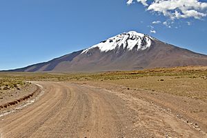
View of Cerro Tuzgle from the southeast
|
|
| Highest point | |
| Elevation | 5,486 m (17,999 ft) |
| Geography | |
Cerro Tuzgle is a sleeping volcano in northwestern Argentina. It is located in the Jujuy Province. This volcano is a tall, cone-shaped mountain made of layers of lava and ash. It stands out in the Andes mountain range.
Cerro Tuzgle's top is about 5,486 meters (18,000 feet) above sea level. It grew over a long time from different eruptions. Some large lava flows came from its top crater. Scientists have also found signs of parts of the volcano collapsing.
The first volcanic activity at Tuzgle happened about 650,000 years ago. This created a rock layer called the Tuzgle Ignimbrite. Later, lava domes and many lava flows erupted. The most recent lava flows are about 300,000 years old. It's possible that volcanic activity continued even more recently. There are several hot springs near the volcano. People have studied these springs to see if they can be used to make geothermal energy. In the past, people used to mine sulfur on the mountain.
Contents
Where is Cerro Tuzgle?
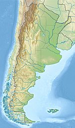
Cerro Tuzgle is a volcano located near the eastern edge of the Puna region in Argentina. It is part of the Jujuy Province. The town of San Antonio de Los Cobres is about 45 kilometers (28 miles) away. The town of Susques is about 75 kilometers (47 miles) away.
The name "Tuzgle" comes from the Kunza language. It means "knoll," which is a small hill. This name describes the volcano's shape.
How does Cerro Tuzgle look?
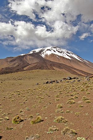
Cerro Tuzgle is a simple, cone-shaped volcano. It is the largest volcano in this part of the Andes. It rises about 1.2 kilometers (0.75 miles) from the land around it. The top of the volcano is 5,486 meters (18,000 feet) high.
Sometimes, the mountain is covered in snow. The cold weather has created interesting patterns on the ground. In 1926, people reported that there was a lake in the crater at the top.
Lava flows and collapses
There are three cracks, called fissure vents, near the top of the volcano. These cracks are the source of dark lava flows. These flows moved south and southwest. The volcanic cone is made up of many lava flows. They are blocky and full of crystals.
Many young-looking lava flows go down the sides of Cerro Tuzgle. One well-preserved lava flow can be seen on its southern side. Older flows traveled up to 9 kilometers (5.6 miles) away from the volcano. A steep slope on the northwestern side of Cerro Tuzgle shows where part of the volcano might have collapsed. A dip on the southern side also suggests a collapse there.
There are old sulfur mines on Cerro Tuzgle. You can see them from the south-southwestern side. One of these mines was called Mina Betty. In 1939, seven sulfur spots were found there. A road was built to reach the top area for mining.
How Cerro Tuzgle Formed
The Andes mountains, where Cerro Tuzgle is, were formed by huge pieces of the Earth's crust, called tectonic plates, moving. The Nazca Plate is sliding underneath the South American Plate. This movement causes volcanoes to form in the Andes.
The Andes have four main volcanic areas. Cerro Tuzgle is in the Central Volcanic Zone. This area has a high flat land called the Altiplano-Puna. Volcanoes here are often found along cracks in the Earth's crust.
Local Volcanoes
Cerro Tuzgle is part of the "back-arc" region of the Andes. This means it's behind the main line of volcanoes. It is about 275 kilometers (170 miles) east of the main volcanic line. It is the largest young volcano in this area.
Other volcanoes nearby include San Jerónimo and Negro de Chorrillos. These volcanoes erupted a long time ago. There's also a large crack in the Earth's crust called the Calama-Olacapato-El Toro lineament. It goes across the Andes near Cerro Tuzgle. This crack might affect how magma moves under the volcano.
What is under the volcano?
Scientists have used special tools to look deep under Cerro Tuzgle. They found a partially melted area of rock, called a magma chamber, between 8 and 22 kilometers (5 to 14 miles) deep. This chamber also contains salty liquids. This is where the hot, melted rock (magma) collects before an eruption.
What is Cerro Tuzgle made of?
The rocks from Cerro Tuzgle are mostly andesite and dacite. These are types of volcanic rock. They are rich in crystals and potassium. The rocks contain large crystals of feldspar and quartz. They also have smaller crystals of other minerals.
Scientists believe the magma for Cerro Tuzgle came from deep inside the Earth. It mixed with parts of the Earth's crust as it rose. This mixing and cooling process created the different types of rocks found at the volcano.
Climate and Nature
The climate at Cerro Tuzgle is cold because it is very high up. Strong winds blow mostly from the west. In winter, there is a lot of sunshine, but not many clouds or rain. People reported in 1939 that thunderstorms and snow are common.
The region is very dry. It gets less than 100 millimeters (4 inches) of rain each year. This is because the Eastern Cordillera mountains block moisture-carrying winds. Most of the little rain that falls comes during the summer.
Plants and Animals
The plants are spread out and include tola, Vachellia caven, and yareta.
Many animals live in the area, such as:
- Chinchillas
- Condors
- Coots
- Darwin's rheas (a type of bird)
- Ducks
- Eagles
- Galea species (small rodents)
- Guanacos (like llamas)
- Llamas
- Suris (a type of alpaca)
- Vicuñas (like small llamas)
Fish called Trichomycterus have been found in the creeks around the volcano.
Eruption History
Cerro Tuzgle was active during the Pleistocene epoch, a long time ago. Its most recent eruption might have happened after a quiet period. Most of its old lava flows are partly covered by wind-blown sand.
The volcano erupted in several stages:
- First, a type of rock called rhyodacitic ignimbrite erupted. This was about 650,000 years ago. It formed a thick, yellow-white plateau. This eruption likely came from a small crater now buried under the volcano.
- Next, lava domes made of dacitic rock formed. These were placed around the edge of the old crater. This happened about 300,000 years ago. These domes are reddish-brown to light grey.
Scientists have two main ideas about what happened next:
- Idea 1:
* Lava flows called the "Pre-platform unit" partly covered the lava domes. These are about 300,000 years old. * Then, a different type of lava filled the old crater, forming the "Platform unit." * Later, new lava flows erupted along cracks in the volcano. These are called the "Postplatform" and "Young Flow" units. Some of these flows are thought to be from the Holocene epoch, which is our current geological time period.
- Idea 2 (from Gianluca Norini and others in 2014):
* Six large lava flows formed the San Antonio Synthem. These are dark grey to reddish-brown. They are found on the southern and northwestern sides of the volcano. A large collapse of the volcano happened at this stage. It created a steep slope on the northwestern side. * After some erosion, the Azufre Synthem formed near the top. These lava flows are also dark grey to reddish-brown. The sulfur deposits on the volcano are linked to this stage. * Finally, 13 lava flows formed the Tuzgle Synthem. These are the last volcanic activity at Cerro Tuzgle. After the eruptions, hot gases and steam continued to come out, depositing more sulfur.
Today, Cerro Tuzgle is not active. Argentina's geological service considers it one of the more dangerous volcanoes in the country. Even though few people live nearby, a future collapse could affect mining and geothermal projects.
Hot Springs and Geothermal Energy
Hot springs are found near Cerro Tuzgle. Agua Caliente de Tuzgle is about 6 kilometers (3.7 miles) northwest of the top. Mina Betty also has a spring about 6 kilometers (3.7 miles) south-southeast. These springs release warm water. Agua Caliente de Tuzgle also releases gases and has created mineral deposits.
The heat for these springs comes from deep underground. Temperatures deep below the surface can be over 200°C (392°F).
Visiting Cerro Tuzgle
Hot springs like Pompeya and Tocomar could be used for tourism. They are close to main roads. The volcano is also a good place for mountaineering. It's not too hard for trained climbers to reach the top.
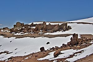
Inca ceremonial sites have been found on the summit. These include a raised platform and structures made of piled rocks. From the top, you can see other volcanoes and mountains.
Sulfur was first found here in 1924. Mining began in 1933 at Mina Betty. The sulfur was taken by mules or trucks to a processing site. Bad weather sometimes stopped mining activities.
In the 1970s and 1980s, companies looked into using the volcano's heat to make geothermal power. They found two hot areas underground. One is closer to the surface, and another is deeper. A major power line runs through the area. Local mines and towns could use this geothermal power. Experts believe it could produce 28–34 megawatts of electricity. However, as of 2020, no power has been generated. The hot springs could also be used for spas or to get minerals. Some people worry that human activity could harm the delicate natural environment.
See also
 In Spanish: Volcán Tuzgle para niños
- List of volcanoes in Argentina


