Chandler's Ford facts for kids
Quick facts for kids Chandler's Ford |
|
|---|---|
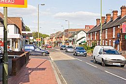
 Junction of Winchester Road and Brownhill Road, Chandler's Ford |
|
| Population | 21,436 |
| OS grid reference | SU435212 |
| Civil parish |
|
| District |
|
| Shire county | |
| Region | |
| Country | England |
| Sovereign state | United Kingdom |
| Post town | EASTLEIGH |
| Postcode district | SO53 |
| Dialling code | 023 |
| Police | Hampshire |
| Fire | Hampshire |
| Ambulance | South Central |
| EU Parliament | South East England |
| UK Parliament |
|
Chandler's Ford is a mostly residential area in Hampshire, England. It's part of the Borough of Eastleigh. In 2011, about 21,436 people lived here.
The name 'Ford' likely refers to a place where people could cross Monks Brook. This crossing was on the old road between Winchester and Southampton. The word "Chandler's" was probably added later, around the late 1500s. No one is completely sure why this part was added.
Many well-known companies have their main offices in Chandler's Ford. These include Draper Tools, B&Q, Utilita Energy, Selwood, and Ahmad Tea.
Contents
History of Chandler's Ford
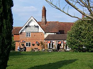
Hiltonbury Farm, which is now a pub, appeared on a map from 1588. It might have first belonged to the Hursley Park Estate. The farm stopped working in the late 1970s when more homes were built around it. Before the 1800s, Chandler's Ford had very few people living there.
In the mid-1800s, Bell's brickfields in the area were very big. They made 35 million bricks! These bricks were used to build the Royal Courts of Justice in London.
In 1889, a church made of iron and some schools were built. The area officially became a civil parish called Chandlersford in 1897. This new parish was made from parts of other nearby areas.
In 1929, a famous architect named Herbert Collins designed the Congregational Church. This building is now the United Reformed Church. It has been made bigger over time, but its original style is still there.
Chandler's Ford used to be mainly housing areas. Now, there are also many shops and schools. Building started in the 1920s in areas like King's Court and Hiltingbury. More homes were built later in other parts of the town. The 'new town' of Valley Park also added to the housing mix.
There isn't one clear 'town centre' in Chandler's Ford. The main shopping area is Fryern Arcade, built in 1967. Other smaller shopping spots are around the Central Precinct and St Boniface Church.
Even though it's mostly a place where people live, Chandler's Ford has a big industrial area. This area has many different businesses. These include light engineering, manufacturing, and distribution. Peter Green Furnishers, a furniture store, was once one of the biggest in Hampshire. Selwoods, another company, has been here since 1946.
A public library was built between 1981 and 1983. In 2018, an Aldi supermarket opened, creating new jobs.
Chandler's Ford has a cricket team called Compton and Chandler's Ford Cricket Club. It was formed in 1995.
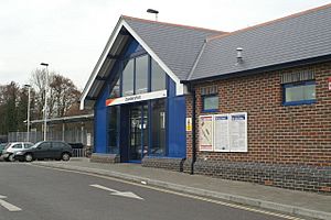
The Chandler's Ford railway station reopened in May 2003. It had been closed since 1969. Now, trains run hourly from Romsey to Salisbury, stopping at Chandler's Ford.
How Chandler's Ford is Governed
Chandler's Ford is a civil parish. This means it has a local council called the Chandler's Ford Parish Council. This council has 18 members who help with local matters.
The area also has representatives on the Eastleigh Borough Council. Most of Chandler's Ford is covered by two wards, Chandler's Ford and Hiltingbury. Each ward elects three councillors.
For Hampshire County Council, most of Chandler's Ford is in one division. This division elects one councillor.
Chandler's Ford is part of the Eastleigh area for national elections. This means people here vote for a Member of Parliament (MP) to represent them in the UK Parliament.
Local elections in Chandler's Ford are usually between the Conservatives and Liberal Democrats. Currently, the Liberal Democrats control the Parish and Borough councils. The County council is controlled by the Conservatives.
People in Chandler's Ford
In April 2011, the Chandler's Ford and Hiltingbury areas had 21,436 people living in 8,896 homes. Most of the people were white. There were also people from mixed race, Asian, Black, and other ethnic groups.
In 2001, most people were Christians. Many people said they had no religion. There were also people who were Buddhists, Hindus, Jews, Muslims, and Sikhs.
Healthcare
Nuffield Health Wessex Hospital in Chandler's Ford provides private and NHS health services.
Transport in Chandler's Ford
Trains
Chandler's Ford has its own train station, which reopened in 2003. You can catch trains to places like Romsey, Salisbury, and Southampton.
Buses
Bluestar's route 1 connects Chandler's Ford with Southampton and Winchester. Xelabus also runs bus services in the area.
Roads
The M3 motorway runs along the eastern side of Chandler's Ford. You can get onto the M3 from junctions 12 and 13.
Education in Chandler's Ford
Chandler's Ford has many schools and nurseries.
Day Nurseries
- Kingsmead Day Nursery
- Sherborne House School
- Bright Horizons Day Nursery and Preschool
Infant and Primary Schools
- Chandler's Ford Infant School
- Fryern Infant School
- Hiltingbury Infant School
- Knightwood Primary School
- Scantabout Primary School
- Sherborne House School
- St Francis Church of England Primary School
- St. Swithun Wells R.C. Primary School
Junior Schools
- Fryern Junior School
- Hiltingbury Junior School
- Merdon Junior School
Secondary Schools
- Lakeside School (a special school)
- Thornden Secondary School
- Toynbee Secondary School
Independent Schools
- Sherborne House School
Community Life
- Valley Park Community Association
- Chandler's Ford Community Association Community Centre
- Hiltingbury Recreation Ground
- Romsey, Chandler's Ford & District Round Table
 | DeHart Hubbard |
 | Wilma Rudolph |
 | Jesse Owens |
 | Jackie Joyner-Kersee |
 | Major Taylor |


