Charlotte River (Michigan) facts for kids
Quick facts for kids Charlotte River |
|
|---|---|

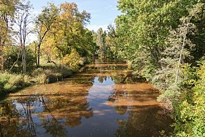
The Charlotte River in Bruce Township
|
|

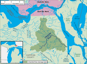
A map of the Charlotte River and its watershed.
|
|
| Country | United States |
| State | Michigan |
| County | Chippewa |
| Townships | Dafter, Bruce |
| Physical characteristics | |
| Main source | Dafter Township 680 ft (210 m) 46°18′52″N 84°24′10″W / 46.314464°N 84.4028184°W |
| River mouth | West Neebish Channel, St. Marys River, Dafter Township 581 ft (177 m) 46°19′07″N 84°13′14″W / 46.3186299°N 84.2205869°W |
| Length | 17.1 miles (27.5 km) |
| Basin features | |
| Progression | St. Marys—Lake Huron—St. Clair—Lake St. Clair—Detroit—Lake Erie—Niagara—Lake Ontario—St. Lawrence—Atlantic Ocean |
| Basin size | 58.4 sq mi (151 km2) |
| Population | 3,451 (2010 estimate) |
| Tributaries |
|
| Hydrologic Unit Codes | 040700010203, 040700010204 (USGS) |
The Charlotte River is a stream in Michigan, United States. It flows into the St. Marys River. The Charlotte River is about 17.1 miles (27.5 km) long. It helps drain an area of about 58.4 square miles (151 km2) in the eastern part of Michigan's Upper Peninsula.
The water from the Charlotte River eventually travels through the Great Lakes system. This includes Lake Huron, the St. Clair River, Lake St. Clair, the Detroit River, Lake Erie, the Niagara River, and Lake Ontario. Finally, it joins the St. Lawrence River and flows into the Atlantic Ocean.
Where Does the Charlotte River Flow?
The entire Charlotte River and the land it drains are located in eastern Chippewa County. The river starts in southeastern Dafter Township. This is about 3.4 miles (5.5 km) south-southeast of the small community of Dafter.
For most of its journey, the river flows through Bruce Township. It first heads northeast, then turns southeast near a place called Rosedale. The Charlotte River then flows into the West Neebish Channel of the St. Marys River. This spot is across from the northern end of Neebish Island. It is also about 13.5 miles (21.7 km) southeast of Sault Ste. Marie, Michigan.
Some maps show a part of the river upstream of Rosedale as the "South Branch Charlotte River." This is a smaller stream that joins the main Charlotte River. The river also has one named smaller stream, called Spring Creek, which is about 3.6 miles (5.8 km) long.
Near where it meets the St. Marys River, the Charlotte River flows through a special area. This area is Michigan State University's Dunbar Forest Experiment Station. It's a place where scientists study how to manage forests.
What is the Land Around the River Like?
The area around the Charlotte River is mostly rural, meaning it's not a big city. Much of this land has been changed for farming, cutting down trees (logging), and building. The soil in this region is mostly clay. It often doesn't drain water very well.
On average, the area gets about 32 inches (81 cm) of rain and snow each year. In winter, there is usually a lot of snow. Water from underground springs, called artesian wells, can make the streams in this area look cloudy.
In 2010, about 3,451 people lived in the Charlotte River area. Most homes in the area use their own septic systems to handle wastewater.
How is the Land Used?
The land around the Charlotte River is used for different things. Here's a look at how the land was used:
- Forests: About 27% of the land is covered by forests.
- Wetlands: About 25% of the land is wetlands, which are areas where the land is covered by water, like swamps or marshes.
- Cropland: About 24% of the land is used for growing crops.
- Pasture: About 18% of the land is pasture, used for grazing animals.
- Developed Areas: About 3% of the land has low-intensity development, like scattered homes or open spaces. Another 0.4% has more developed areas.
- Grassland: About 3% of the land is grassland.
- Bare Land: A very small part, about 0.4%, is bare land.
- Open Water: An even smaller part, about 0.08%, is open water like ponds or small lakes.
 | William L. Dawson |
 | W. E. B. Du Bois |
 | Harry Belafonte |

