Chautauqua, New York facts for kids
Quick facts for kids
Chautauqua, New York
|
|
|---|---|

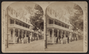
View of Simpson Avenue
|
|

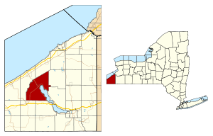
Location of Chautauqua in Chautauqua County, New York and New York
|
|
| Country | United States |
| State | New York |
| County | Chautauqua |
| Government | |
| • Type | Town council |
| Area | |
| • Total | 67.49 sq mi (174.80 km2) |
| • Land | 67.40 sq mi (174.56 km2) |
| • Water | .09 sq mi (.24 km2) |
| Elevation | 1,342 ft (409 m) |
| Population
(2020)
|
|
| • Total | 4,009 |
| • Estimate
(2022)
|
4,014 |
| • Density | 59.48/sq mi (22.97/km2) |
| Time zone | UTC-5 (Eastern (EST)) |
| • Summer (DST) | UTC-4 (EDT) |
| ZIP code |
14722
|
| Area code(s) | 716 |
| FIPS code | 36-013-14069 |
| GNIS feature ID | 0978815 |
Chautauqua (pronounced shə-TAW-kwə) is a town and a popular lake resort community. It is located in Chautauqua County, New York. In 2020, about 4,009 people lived here.
The town is named after Chautauqua Lake. It is also famous for being the home of the Chautauqua Institution. This institution is where the Chautauqua movement began. The movement focused on adult education and social gatherings.
Contents
Chautauqua's Early History
How Chautauqua Town Began
The town of Chautauqua was officially created on April 11, 1805. It was formed from a larger area called Batavia. The very first settler arrived in the area a year before, near where the village of Mayville is today.
When Chautauqua County was formed in 1808, the town of Chautauqua grew even bigger. It became so large that it covered the entire new county. Because of this, Chautauqua is known as the "mother of towns" in the county. All other towns in Chautauqua County were once part of it. Even today, it remains one of the largest towns in the county.
What Does "Chautauqua" Mean?
The exact meaning of the name "Chautauqua" is still a mystery. People have wondered about it for a long time. Two common ideas are "bag tied in the middle" or "place where fish are taken out." The idea about fish might be true because similar words are found in other Native American languages from the Iroquois people.
Chautauqua in the 20th Century
Traveling to Chautauqua
In the early 1900s, when the Chautauqua Institution was very popular, trains were the main way people traveled to the town. Until 1926, a special train called the Chautauqua Traction interurban ran daily. It connected Chautauqua to Mayville and then to Westfield. In the other direction, it went to Lakewood and Jamestown.
Later, in the 1940s, the Pennsylvania Railroad offered train service nearby in Mayville. This route connected Pittsburgh and Buffalo. Before and during the time of these interurban trains, steamboats were also very popular. They helped people travel to different parts of Chautauqua Lake from Mayville and Jamestown.
Important Historic Places
Several places in Chautauqua are recognized for their history. The Lewis Miller Cottage at the Chautauqua Institution is one of them. It was listed as a National Historic Landmark in 1966. This means it's a very important historic site in the United States.
The entire Chautauqua Institution Historic District was also listed in 1974. This shows that the whole area has a special historical value.
Chautauqua's Geography
Chautauqua is a large town. It covers about 174 square kilometers (67.49 square miles). Most of this area is land, with only a small part being water.
Neighboring Towns Around Chautauqua
Chautauqua is surrounded by several other towns. Here they are, listed like points on a compass:
- Portland is to the north.
- Stockton and Ellery are to the east.
- North Harmony and Sherman are to the south.
- Westfield is to the west.
Population of Chautauqua
| Historical population | |||
|---|---|---|---|
| Census | Pop. | %± | |
| 1820 | 2,518 | — | |
| 1830 | 2,432 | −3.4% | |
| 1840 | 2,980 | 22.5% | |
| 1850 | 2,622 | −12.0% | |
| 1860 | 2,837 | 8.2% | |
| 1870 | 3,064 | 8.0% | |
| 1880 | 3,570 | 16.5% | |
| 1890 | 3,259 | −8.7% | |
| 1900 | 3,590 | 10.2% | |
| 1910 | 3,515 | −2.1% | |
| 1920 | 3,533 | 0.5% | |
| 1930 | 3,802 | 7.6% | |
| 1940 | 3,819 | 0.4% | |
| 1950 | 4,222 | 10.6% | |
| 1960 | 4,376 | 3.6% | |
| 1970 | 4,341 | −0.8% | |
| 1980 | 4,728 | 8.9% | |
| 1990 | 4,554 | −3.7% | |
| 2000 | 4,666 | 2.5% | |
| 2010 | 4,464 | −4.3% | |
| 2020 | 4,009 | −10.2% | |
| 2022 (est.) | 4,014 | −10.1% | |
| U.S. Decennial Census | |||
The population of Chautauqua has changed over the years. In 2000, there were 4,666 people living in the town. These people lived in 1,881 households. About 1,269 of these households were families.
Most people in Chautauqua are White (96.3%). A smaller number are African American (1.6%), Native American (0.2%), or Asian (0.4%). Some people are also from two or more races (1.3%). About 1.1% of the population is Hispanic or Latino.
In 2000, about 27.1% of households had children under 18 living with them. The average age of people in the town was 41 years old.
Getting Around Chautauqua
The two main roads in Chautauqua are New York State Route 394 and New York State Route 430. These roads meet in the village of Mayville.
Route 394 travels from Jamestown along the western side of Chautauqua Lake. It then continues on to Westfield. Route 430 also comes from Jamestown, but it travels along the eastern side of the lake. From Mayville, it goes southwest towards the state border. There, it becomes Pennsylvania Route 430.
Places to See in Chautauqua
- Chautauqua – This is a small community (called a hamlet) on the west shore of Chautauqua Lake. It's where the famous Chautauqua Institution is located.
- Chautauqua Creek – A stream that forms part of the town's border with Westfield.
- Chautauqua Institution – A special place for education and a summer resort. It's on Route 394.
- Chautauqua post office – The local post office, found inside the gates of the Chautauqua Institution.
- Cottage Park – A small community by the lake, south of Mayville on Route 394.
- Dart Airfield (D79) – A small airport with a grass runway, located east of Mayville.
- Dean – A community in the northeast part of the town.
- Dewittville – A community by the lake on the east side of Chautauqua Lake.
- Dewittville Bay – A bay near Point Chautauqua.
- Hartfield – A community in the northeast part of the town.
- Hartfield Bay – A bay at the northern end of Chautauqua Lake.
- Irwins Bay – A small bay between Lighthouse Point and Wahmeda.
- Lakeside Park – A small community by the lake, south of Mayville.
- Lighthouse Point – A community on a piece of land sticking into the lake, south of Mayville.
- Magnolia – A community by the lake in the southeast part of the town.
- Mayville – This village is the main town (county seat) for Chautauqua County. It's at the north end of Chautauqua Lake.
- Orchard Terrace – A community by the lake, south of Chautauqua.
- Pleasantville – A community near the eastern town line.
- Point Chautauqua – A community on a peninsula (land surrounded by water on three sides) on the eastern side of the lake.
- Point Pleasant – A piece of land sticking into Chautauqua Lake, south of Mayville.
- Prendergast Point – Another piece of land sticking into Chautauqua Lake, in the southeast part of the town.
- Shorelands – A community on the east side of Chautauqua Lake, east of Mayville.
- Summerdale – A community in the western part of the town.
- Wahmeda – A community by the lake, north of Chautauqua.
- Wooglin – A community by the lake on the east side of the lake.
Famous People from Chautauqua
- Arthur Bestor – A historian and critic of public education.
- John Jachym – A businessman, generous giver, and sportsman.
- Michael John LaChiusa – A composer who writes music for theater.
- Hiram Lawton Richmond – A former U.S. Congressman from Pennsylvania.
- Gar Samuelson – The original drummer for the band Megadeth.
- Glenni William Scofield – A U.S. Congressman from Pennsylvania.
- Garnet Sixsmith – One of the first professional ice hockey players.
- Heidi VanDerveer – A women's basketball coach.
See also
 In Spanish: Chautauqua (Nueva York) para niños


