Chehalis Gap facts for kids
Quick facts for kids Chehalis Gap |
|
|---|---|

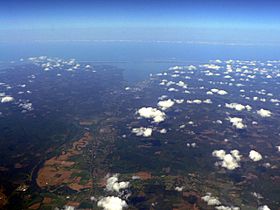
Looking west through Chehalis Gap; Chehalis River (left of center) leading to Grays Harbor (middle distance) and Pacific Ocean (far distance)
|
|
| Elevation | 463 ft (141 m) |
| Traversed by | U.S. Route 12, fmr. U.S. Route 410, Puget Sound and Pacific Railroad |
| Location | Washington, United States |
| Range | Coast Range |
| Coordinates | 47°0′N 123°5′W / 47.000°N 123.083°W |
The Chehalis Gap is a special valley in Washington state. It's like a big opening in the Coast Mountains. It sits between the lower parts of the Olympic Mountains (called the Satsop Hills) and the Willapa Hills.
This gap is a very important natural feature in the northwestern United States. Inside the gap, you'll find the Chehalis River, Grays Harbor (a large bay), and the Grays Harbor National Wildlife Refuge. A major road, U.S. Route 12, goes through the gap from Elma to Aberdeen.
Contents
How the Chehalis Gap Was Formed
Imagine a huge river! The Chehalis Gap is a very wide valley, much wider than the Chehalis River that flows through it today. Scientists believe this valley became so big during the Pleistocene ice age.
During that time, giant glaciers, some as tall as a mile, covered what is now the Puget Sound region. As these glaciers melted, massive amounts of water rushed through this area. This powerful meltwater carved out the wide valley we see today, making the Chehalis Gap much larger than it would be with just the Chehalis River.
Weather and Climate Effects
The Chehalis Gap plays a big role in the weather and climate of the Puget Sound region. It helps create several interesting weather patterns.
How the Gap Affects Rain
The gap allows moist air from the Pacific Ocean to move inland. This is why areas near the gap, like Olympia, get a lot more rain than cities farther away, such as Seattle. Without the Chehalis Gap, the climate in the Puget Sound area would be much drier, similar to the semi-arid conditions in Eastern Washington.
Air Quality and Ocean Breezes
The gap also helps keep the air fresh in the Puget Sound region. It allows fresh Pacific air to flow in, which helps to clear out air pollution from cities and factories. This is important because without this fresh air, pollution could get trapped and make the air unhealthy.
The Low-Level Jet Stream
Sometimes, a special kind of wind called a low-level jet forms near the Chehalis Gap. This is like a fast-moving river of air close to the ground. It can influence how weather systems move through the area.
Water Supply for Cities
The amount of rain that falls in the Puget Sound area is very important for the water supply of its cities. The Chehalis Gap helps bring in the moisture needed for this rain.
Cities like Seattle, Everett, and Bremerton all rely on reservoirs in the hills around them for their drinking water. These reservoirs collect water from rain and storms, especially during the winter. The unique shape of the land and the presence of the Chehalis Gap mean that moist air from the Pacific Ocean often drops a lot of rain in these elevated areas, helping to fill the reservoirs.

