
City of San Marino facts for kids
Quick facts for kids
City of San Marino
Città di San Marino
|
|||
|---|---|---|---|
|
Capital city and castello
|
|||
|
Clockwise from top: view of Monte Titano, the aerial cable car, San Marino Cathedral, Via Basilicus, panorama from the top, De La Fratta Tower, Guaita Tower, Palazzo Pubblico
|
|||
|
|||
.svg)
San Marino's location in San Marino
|
|||

City of San Marino
Location in San Marino

City of San Marino
Location in Europe
|
|||
| Country | |||
| Foundation | 3 September 301 (traditional date) | ||
| Curazie |
List
Cà Berlone, Canepa, Casole, Castellaro, Montalbo, Murata, Santa Mustiola
|
||
| Area | |||
| • Total | 7.09 km2 (2.74 sq mi) | ||
| Elevation | 749 m (2,457 ft) | ||
| Population
(January 2022)
|
|||
| • Total | 4,061 | ||
| • Density | 582.23/km2 (1,508.0/sq mi) | ||
| Time zone | UTC+1 (CET) | ||
| • Summer (DST) | UTC+2 (CEST) | ||
| Postal code |
RSM-47890
|
||
| Climate | Cfb | ||


| UNESCO World Heritage Site | |
|---|---|

Monte Titano and three fortresses on top of it can be seen from many kilometers away
|
|
| Criteria | Cultural: iii |
| Inscription | 2008 (32nd Session) |
| Area | 55 ha |
| Buffer zone | 167 ha |
The City of San Marino is the capital city of the small country of San Marino. People also call it just San Marino or Città (which means 'City' in Italian). It's one of the nine main areas, called castelli, in the country. About 4,061 people live here. The city sits on the western side of Monte Titano, which is the highest mountain in San Marino. It's also one of the smallest capital cities in the world by population!
Contents
Exploring San Marino's Geography
The City of San Marino shares its borders with other castelli (towns) in San Marino. These include Acquaviva, Borgo Maggiore, Fiorentino, and Chiesanuova. It also borders an Italian town called San Leo.
The City of San Marino is made up of seven smaller areas called curazie. These are Cà Berlone, Canepa, Casole, Castellaro, Montalbo, Murata, and Santa Mustiola.
A Look at San Marino's History
People believe that Saint Marinus founded the city in the year 301. He was a Christian refugee running away from Roman persecution.
The city's main area was protected by three strong towers. The first tower, Guaita, was built in the 11th century. It was known for being so strong that it often stopped enemies from attacking.
As tensions grew with nearby areas, a second tower, Cesta, was built in the 13th century. The defense system was finished with the third tower, Montale, built in the 14th century. This was the smallest tower and stood on the last peak of Monte Titano.
As more people moved to the city, San Marino's land grew. The country didn't invade or fight wars to get new land. Instead, it bought land or made agreements. This is how San Marino gained the other eight castelli that make up the country today.
San Marino's Economy and What People Do
The City of San Marino's economy has always been linked to the country's economy. In the past, people mainly worked by digging up and carving stone.
Today, the economy is more varied. It includes tourism, shopping, and selling special postage stamps. There's also a small farming industry, but it's becoming less common.
Popular Places to Visit

More than three million people visit the city each year. It has become a very popular place for tourists. About 85% of these visitors are from Italy. You can also find over a thousand shops selling many different products.
Main Sights to See
- Basilica di San Marino
- Palazzo dei Capitani
- Palazzo Pubblico (the City Hall)
- Teatro Titano (a theater)
- The Three Towers of San Marino
- Piazza del Titano (a main square)
- Piazza Garibaldi (another square)
- Monastery of Santa Clara
- Grand Hotel San Marino
Getting Around San Marino
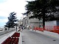
The city is famous for its long, winding streets made of cobblestones. Because it's so high up and steep, cars can't reach much of the city center. A series of lifts helps people get from the lower part of the city to the upper part.
The City of San Marino is the top station for the Funivia di San Marino. This is an aerial cable car system that connects the city to Borgo Maggiore. The cable car runs every fifteen minutes. The ride takes only two minutes and offers amazing views of San Marino, the nearby Province of Rimini, and the Adriatic Sea. The cable car station in the City of San Marino is near the historic city center. It's also close to the Basilica of San Marino and the Piazza della Libertà.
The City of San Marino is the starting point for most of San Marino's bus lines. These buses connect the city to other towns in the country. You can also catch a regular bus from the central bus stop to Rimini in Italy.
Between 1932 and 1944, a special electric railway ran between Rimini and the City of San Marino. It was about 31.5 kilometers long. During World War II, the railway was bombed and closed. Its tunnels were used to shelter people during battles. After the war, the railway was replaced by a highway.
In 2012, a small part of the railway, about 800 meters long, was reopened. It's now a heritage railway in the City of San Marino. This section includes the original railway's final curve through the Montale tunnel.
Sports in the City
The City of San Marino has three football (soccer) teams. They are the S.S. Murata, the S.P. Tre Penne, and the San Marino Academy. The city was also part of the journey for the Olympic Flame before the 2006 Winter Olympics.
International Connections
The City of San Marino has special partnerships, called "sister cities," with other cities around the world:
 Rab, Croatia (since 1968)
 San Leo, Italy (since 1995)
 Nanjing, China (since 2021)
Images for kids
-
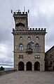
Palazzo Pubblico,
the City Hall -
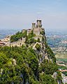
Guaita tower
-
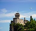
Cesta tower
-
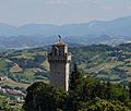
Montale tower
-
Via Paul III
-
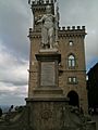
Statue of Liberty in the square of the City Hall
-
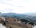
Panoramic view from Murata
.jpg)


See also
 In Spanish: Ciudad de San Marino para niños
