Claremore, Oklahoma facts for kids
Quick facts for kids
Claremore, Oklahoma
|
|
|---|---|

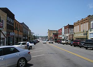
Downtown Claremore
|
|
| Motto(s):
"New Vision. Clear Opportunities."
|
|

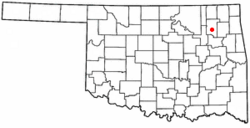
Location in the state of Oklahoma
|
|
| Country | United States |
| State | Oklahoma |
| County | Rogers |
| Incorporated | 1883 |
| Area | |
| • Total | 15.26 sq mi (39.53 km2) |
| • Land | 15.01 sq mi (38.87 km2) |
| • Water | 0.25 sq mi (0.66 km2) |
| Elevation | 610 ft (190 m) |
| Population
(2020)
|
|
| • Total | 19,580 |
| • Density | 1,304.64/sq mi (503.71/km2) |
| Time zone | UTC-6 (CST) |
| • Summer (DST) | UTC-5 (CDT) |
| ZIP codes |
74017, 74018, 74019
|
| Area code(s) | 539/918 |
| FIPS code | 40-14700 |
| GNIS feature ID | 2409466 |
| Website | www.claremorecity.com |
Claremore is a city in northeastern Oklahoma, United States. It is the main city of Rogers County. In 2020, about 19,580 people lived there. This was a small increase from 2010. Claremore is located near the Ozark Mountains. It is also home to Rogers State University. The city is part of the larger Tulsa area.
Long ago, this land belonged to the Osage people. Later, it became part of the Cherokee Nation's territory. The Cherokee had moved here from the southeastern United States. This area was known as the Cherokees' Cooweescoowee District.
Contents
History of Claremore
Around 1802, groups of Osage Indians settled in this part of Oklahoma. A chief named Clermont (also called Claremore) lived with his group in a village called Pasuga. This name meant "Big Cedar." The village was built on an old earth mound.
In June 1817, Cherokee warriors attacked and destroyed the Osage village of Pasuga. This event is known as the Battle of Claremore Mound. Most of the Osage men were away hunting bison. The Cherokee killed the men in the village. They also captured over 100 women and children. These captives were then sold to other Cherokee groups.
After 1830, this area became part of Indian Territory. Much of it was given to the Cherokee Nation. Claremore and the mound were in the Cooweescoowee District of the Cherokee Nation.
The Rogers family was among the first European-American settlers. Clem Rogers, the father of famous entertainer Will Rogers, moved here in 1856. He owned a large ranch called Dog Iron Ranch. Clem Rogers helped Oklahoma become a state. He was the oldest person at the state's Constitutional Convention in 1907. His home is still a historical site near Oologah.
A post office opened in Claremore on June 25, 1874. The town grew quickly when railroads came through. Two major train lines met in the center of town. The town's name changed from Clermont to Claremore on September 19, 1882. A clerk made a spelling mistake, and the new spelling stuck. Claremore officially became a town in the Cherokee Nation on May 2, 1903. The local newspaper, the Claremore Daily Progress, started in 1893. It is the oldest business in Rogers County.
In the early 1900s, people thought that bathing in sulphur springs had health benefits. In 1903, a man named George Eaton found an underground pool of water that smelled like sulfur. A local doctor tested it and called it "Radium Water." It didn't have radium, but it had sulfur compounds. People believed these were good for health. Eaton built a bath house and called the area Radium Town. Many bath houses were built, attracting visitors.
Claremore has many old homes and buildings. The downtown area was updated between 2002 and 2007. On May 25, 2024, a strong tornado hit Claremore. It caused a lot of damage to the city and nearby areas.
Geography of Claremore
Claremore covers about 12.3 square miles. Most of this is land, with a small amount of water.
The city is in a region called Green Country. This part of Oklahoma is known for its green plants, hills, and lakes. Claremore is near the Verdigris River. The city gets its water from Claremore and Oologah lakes. Both lakes are part of the Verdigris River system.
Climate in Claremore
Claremore has a humid subtropical climate. This means it has cold winters and hot summers.
| Climate data for Claremore, Oklahoma | |||||||||||||
|---|---|---|---|---|---|---|---|---|---|---|---|---|---|
| Month | Jan | Feb | Mar | Apr | May | Jun | Jul | Aug | Sep | Oct | Nov | Dec | Year |
| Mean daily maximum °F (°C) | 44.8 (7.1) |
50.3 (10.2) |
60.2 (15.7) |
71.2 (21.8) |
78.3 (25.7) |
86.3 (30.2) |
92.8 (33.8) |
92.0 (33.3) |
83.6 (28.7) |
73.6 (23.1) |
60.5 (15.8) |
48.8 (9.3) |
70.2 (21.2) |
| Mean daily minimum °F (°C) | 21.2 (−6.0) |
26.1 (−3.3) |
35.7 (2.1) |
46.8 (8.2) |
55.7 (13.2) |
64.9 (18.3) |
69.5 (20.8) |
67.3 (19.6) |
60.4 (15.8) |
47.2 (8.4) |
36.5 (2.5) |
26.0 (−3.3) |
46.4 (8.0) |
| Average precipitation inches (mm) | 1.6 (41) |
2.0 (51) |
3.6 (91) |
3.6 (91) |
4.6 (120) |
4.6 (120) |
3.0 (76) |
3.1 (79) |
4.5 (110) |
3.6 (91) |
3.2 (81) |
2.2 (56) |
39.4 (1,000) |
| Source 1: weather.com | |||||||||||||
| Source 2: Weatherbase.com | |||||||||||||
Getting Around Claremore
Claremore is a place where several important highways meet. Interstate 44 passes through the southeast part of town. Historic Route 66 (now State Highway 66) is one of the main roads. State Highway 88 and State Highway 20 also cross paths in Claremore.
Two major railroad lines also meet in Claremore. These are the Kansas and Arkansas Valley Railway line (now Union Pacific) and the "Frisco" line (now BNSF).
The Claremore Regional Airport is about 7 miles east of the city. For bigger flights, Tulsa International Airport is about 22 miles southwest.
People in Claremore
| Historical population | |||
|---|---|---|---|
| Census | Pop. | %± | |
| 1900 | 855 | — | |
| 1910 | 2,866 | 235.2% | |
| 1920 | 3,435 | 19.9% | |
| 1930 | 3,720 | 8.3% | |
| 1940 | 4,134 | 11.1% | |
| 1950 | 5,494 | 32.9% | |
| 1960 | 6,639 | 20.8% | |
| 1970 | 9,084 | 36.8% | |
| 1980 | 12,085 | 33.0% | |
| 1990 | 13,280 | 9.9% | |
| 2000 | 15,873 | 19.5% | |
| 2010 | 18,581 | 17.1% | |
| 2020 | 19,580 | 5.4% | |
| Sources: | |||
In 2000, Claremore had about 15,873 people. Most residents were White, with a good number of Native American people. There were also smaller groups of African American and Asian residents. About 3% of the population was Hispanic or Latino.
About one-fourth of the people were under 18 years old. The average age in Claremore was 36 years old.
Education in Claremore
Claremore is home to the main campus of Rogers State University. This university offers different college degrees. It serves over 4,300 students. It is the only public four-year university in the Tulsa Metropolitan Area.
There is also a campus of Northeast Tech in Claremore. This school offers job training classes. It helps over 200 students learn skills for different careers.
The public schools in Claremore are part of the Claremore Independent School District. This includes Claremore High School, Will Rogers Junior High, and several elementary schools.
The first school in the Claremore area opened in 1870. A large high school was built in 1919. It was the most expensive public school building in Oklahoma at that time. It was used as a school for almost 80 years.
Claremore's Economy
Claremore has a varied economy. Baker Hughes, a company that works with oil fields, has a big office here. Several other large companies are in the Claremore Industrial Park. This park is close to the Tulsa Port of Catoosa. This port is on the Verdigris and Arkansas rivers. Coal mining is also an important business in the area.
Claremore Media
Claremore has a website called moreClaremore.com. This site shares positive news about the community. It started in 2013. It focuses on local events, businesses, people, and schools. It also has a community calendar.
The local newspaper is the Claremore Daily Progress. It started in 1892 as a weekly paper. It became a daily paper in 1893. It is one of the oldest businesses in Rogers County. As of 2020, it prints two times a week.
Historic Places in Claremore
The National Register of Historic Places lists several sites in Claremore. These places are important for their history. They are kept safe for future generations.
| Name on the Register | Image | Date listed | Location | City or town | Description | |
|---|---|---|---|---|---|---|
| 1 | The Belvidere |
(#82003696) |
109 N. Chickasaw Ave. 36°18′39″N 95°36′37″W / 36.310833°N 95.610278°W |
Claremore | ||
| 2 | Claremore Auto Dealership |
(#95000042) |
625 W. Will Rogers Boulevard 36°18′46″N 95°37′02″W / 36.312778°N 95.617222°W |
Claremore | This building was listed for its special architecture. It was built between 1925 and 1949. | |
| 3 | Downtown Claremore Historic District |
(#16000623) |
W. Will Rogers Blvd. bounded by Rt. 66, Muskogee Ave., 4th St. & alley between W. Will Rogers Blvd. & 2nd St. 36°18′43″N 95°36′53″W / 36.312013°N 95.614759°W |
Claremore | ||
| 4 | Eastern University Preparatory School |
(#82003697) |
College Hill 36°19′12″N 95°38′07″W / 36.32°N 95.635278°W |
Claremore | ||
| 5 | Mendenhall's Bath House |
(#83002127) |
601 E. 7th St. 36°18′39″N 95°36′02″W / 36.310833°N 95.600556°W |
Claremore | ||
| 6 | Maurice Meyer Barracks |
(#82003698) |
College Hill 36°19′08″N 95°38′07″W / 36.318889°N 95.635278°W |
Claremore | ||
| 7 | Will Rogers Hotel |
(#94001508) |
524 W. Will Rogers Boulevard 36°18′45″N 95°36′55″W / 36.3125°N 95.615278°W |
Claremore |
Other Fun Places to Visit
- J. M. Davis Arms and Historical Museum
- Will Rogers Memorial Museum
- Will Rogers Downs
- Oklahoma Military Academy Museum
Famous People From Claremore
- Levy Adcock, football player
- Brad Carson, former U.S. Congressman
- Rotnei Clarke, basketball player
- Carrie Barefoot Dickerson, activist
- Frankie Hargis (1965–2021), Cherokee Nation Registrar and Tribal Councilor
- Mercedes Lackey, author
- Patti Page, singer and entertainer
- Carl Radle, bassist
- Dave Rader, baseball player
- Lynn Riggs, playwright
- Will Rogers, famous entertainer, comedian, and actor
- Stuart Roosa, astronaut
- Barbara Starr Scott (1939–2020), Cherokee Nation tribal councilor
- Kywin Supernaw, NFL player
- Janees Taylor, Cherokee Nation Treasurer and Tribal Councilor
- Kimberly Teehee, delegate for the Cherokee Nation to the U.S. House of Representatives
- Helen Walton, philanthropist and wife of Walmart founder Sam Walton
- Madison Whitekiller, 2017–18 Miss Cherokee
- Tito Jackson, member of the Jackson 5
Sister Cities
Images for kids
-
The Will Rogers Memorial overlooks Claremore.
See also
 In Spanish: Claremore (Oklahoma) para niños
 | James Van Der Zee |
 | Alma Thomas |
 | Ellis Wilson |
 | Margaret Taylor-Burroughs |


