Clay County, South Dakota facts for kids
Quick facts for kids
Clay County
|
|
|---|---|

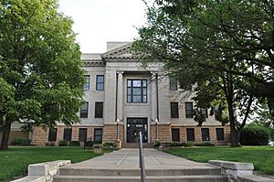
Clay County Courthouse
|
|

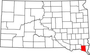
Location within the U.S. state of South Dakota
|
|
 South Dakota's location within the U.S. |
|
| Country | |
| State | |
| Founded | 1862 |
| Named for | Henry Clay |
| Seat | Vermillion |
| Largest city | Vermillion |
| Area | |
| • Total | 417 sq mi (1,080 km2) |
| • Land | 412 sq mi (1,070 km2) |
| • Water | 5.1 sq mi (13 km2) 1.2% |
| Population
(2020)
|
|
| • Total | 14,967 |
| • Estimate
(2023)
|
15,431 |
| • Density | 35.89/sq mi (13.858/km2) |
| Time zone | UTC−6 (Central) |
| • Summer (DST) | UTC−5 (CDT) |
| Congressional district | At-large |
Clay County is a county located in the state of South Dakota in the United States. In 2020, about 14,967 people lived here. The main city and county seat is Vermillion. This city is also home to the University of South Dakota.
The county is named after Henry Clay. He was an important American statesman and a Senator from Kentucky. He also served as United States Secretary of State in the 1800s. Clay County is part of the Vermillion, SD Micropolitan Statistical Area.
Contents
History of Clay County
The area that is now Clay County was first opened for people to legally settle in 1859. In the fall of 1859, a man named Ahira A. Partridge crossed the Missouri River. He was the first white person to settle there. He chose 160 acres of land where the city of Vermillion now stands.
In 1862, Clay County was officially set up as a county. The Clay County Courthouse, an important building for the county government, was built in 1912. It's interesting to know that there are 17 other counties in the United States named Clay County. Most of them are also named after Henry Clay.
Geography of Clay County
Clay County is located in the southern part of South Dakota. Its southern border is next to the state of Nebraska, across the Missouri River. The Missouri River flows along this southern border.
The land in Clay County is mostly used for farming. Water from the county flows into the Missouri River through small streams and drainages. The county has a total area of about 417 square miles. Most of this (412 square miles) is land, and a small part (5.1 square miles) is water. It is the smallest county in South Dakota by land area.
Neighboring Counties
- Turner County - to the north
- Lincoln County - to the northeast
- Union County - to the east
- Dixon County, Nebraska - to the southeast
- Cedar County, Nebraska - to the southwest
- Yankton County - to the west
Main Roads
Protected Natural Areas
- Missouri National Recreational River (a part of it is in Clay County)
- Spirit Mound State Historic Prairie
People of Clay County (Demographics)
| Historical population | |||
|---|---|---|---|
| Census | Pop. | %± | |
| 1870 | 2,621 | — | |
| 1880 | 5,001 | 90.8% | |
| 1890 | 7,509 | 50.1% | |
| 1900 | 9,316 | 24.1% | |
| 1910 | 8,711 | −6.5% | |
| 1920 | 9,654 | 10.8% | |
| 1930 | 10,088 | 4.5% | |
| 1940 | 9,592 | −4.9% | |
| 1950 | 10,993 | 14.6% | |
| 1960 | 10,810 | −1.7% | |
| 1970 | 12,923 | 19.5% | |
| 1980 | 13,689 | 5.9% | |
| 1990 | 13,186 | −3.7% | |
| 2000 | 13,537 | 2.7% | |
| 2010 | 13,864 | 2.4% | |
| 2020 | 14,967 | 8.0% | |
| 2023 (est.) | 15,431 | 11.3% | |
| U.S. Decennial Census 1790-1960 1900-1990 1990-2000 2010-2020 |
|||
2020 Census Information
According to the 2020 census, there were 14,967 people living in Clay County. There were 5,564 households and 2,795 families. The population density was about 36 people per square mile.
2010 Census Information
In the 2010 census, there were 13,864 people. About 91.1% of the people were White. Other groups included American Indian (3.1%), Asian (1.7%), and Black or African American (1.3%). About 2.0% of the population was of Hispanic or Latino origin.
Many people in Clay County have German (43.9%), Norwegian (16.4%), or Irish (15.8%) backgrounds. The average age of people in the county was 25.0 years old.
Education in Clay County
The University of South Dakota is an important part of Clay County. In 1862, the government decided to build the State University in Vermillion. Work on the campus began in 1882 when Clay County provided $10,000 to help build a new building.
Communities in Clay County
Cities
- Irene (part of this city is in Clay County)
- Vermillion (This is the county seat, meaning it's where the county government is located.)
Town
Census-Designated Places
These are areas that are like towns but are not officially incorporated as cities or towns.
Unincorporated Communities
These are small communities that do not have their own local government.
- Alsen (part of this community is in Clay County)
- Dalesburg
- Greenfield
- Hub City
- Westreville
Townships
Townships are smaller areas within a county, often used for local administration.
- Bethel
- Fairview
- Garfield
- Glenwood
- Meckling
- Norway
- Pleasant Valley
- Prairie Center
- Riverside
- Spirit Mound
- Star
- Vermillion
See also
 In Spanish: Condado de Clay (Dakota del Sur) para niños

